Download presentation
Presentation is loading. Please wait.

1
Northeastern and Upper Midwestern Terrestrial Habitat Classification System Getting started in the Midwest…

2
Objectives NAASF is looking to upgrade the state wildlife plans across the region to be more in sync with each other. – updating existing maps and classifications to the USNVC and ecological systems – implementation of the SWAPs within each state and across the MW region will be greatly enhanced through the development of current, consistent habitat GIS datasets.

3
Benefits Final classification and map will reflect a balance between the state needs and consistency across the region which will aid SWAPs and other partners in working on conservation goals across a 21 state region of the MW and NE

4
Area of Study

5
Final Products from NE Project Terrestrial regional habitat classification system Detailed terrestrial habitat GIS dataset for the region (underway) Standardized GIS dataset of currently secured lands (i.e., protected or conserved areas) throughout the region Standing NE regional habitat mapping coordinating committee
 Standardized GIS dataset of currently secured lands (i.e., protected or conserved areas) throughout the region Standing NE regional habitat mapping coordinating committee")
6
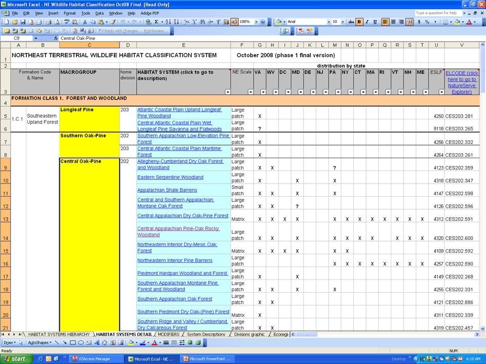
Example from the NE

7
Steps for the Midwest Develop consistent classification Map classification over 8-state region Link to NE Map to help create a 21-state regional map

8
Terrestrial Habitat Classification Based on Ecological Systems Added classes for altered habitats and land-use types Systems component is hierarchical with upper levels of Formation and Macrogroup Compatible with Landfire approaches in region.

9
ECOLOGICAL SYSTEMS OF THE UNITED STATES A WORKING CLASSIFICATION OF U.S. TERRESTRIAL SYSTEMS 2003 Comer, P., D. Faber-Langendoen, R. Evans, S. Gawler, C. Josse, G. Kittel, S. Menard, M. Pyne, M. Reid, K. Schulz, K.Snow, and J. Teague.

10
Ecological Systems: groups of biological communities (associations or types) that co-occur on the landscape share similar physical environments influenced by similar dynamic ecological processes practical, mid-scale units that inform resource management decisions – mappable & identifiable – intermediate geographic scales (10 1 - 10 3 ha) – temporally persistent (>50 yrs)
 that co-occur on the landscape share similar physical environments influenced by similar dynamic ecological processes practical, mid-scale units that inform resource management decisions – mappable & identifiable – intermediate geographic scales ( ha) – temporally persistent (>50 yrs)")
11
Examples of Ecological Systems in the Midwest

12
Boreal Jack Pine-Black Spruce Forest Great Lakes Dune South-Central Interior Mesophytic Forest Laurentian-Acadian Alkaline Fen

13
Terrestrial Habitat Classification Based on Ecological Systems Added classes for altered habitats and land-use types Systems component is hierarchical with upper levels of Formation and Macrogroup Compatible with Landfire approaches in region.

14
Examples of altered habitats and land-use types from Northeast Project

15
Ruderal Forest - Northern and Central Hardwood and Conifer Ruderal Upland - Old Field

16
Residential - Rural / Sparse

17
Terrestrial Habitat Classification Based on Ecological Systems Added classes for altered habitats and land-use types Systems component is hierarchical with upper levels of Formation and Macrogroup Compatible with Landfire approaches in region.

18
systems can be aggregated into higher-level units where these are useful: Formation*Macrogroup*Habitat System Lowland & Montane Boreal Forest Eastern & Central North American Boreal Conifer & Hardwood Forest Boreal Jack Pine- Black Spruce Forest * From the FGDC-standard levels of the National Vegetation Classification.

19
Terrestrial Habitat Classification Based on Ecological Systems Added classes for altered habitats and land-use types Systems component is hierarchical with upper levels of Formation and Macrogroup Compatible with Landfire approaches in region.

20
LANDFIRE Mapped ecological systems Focused on upland habitats Developed field keys to systems Developed automated classification tools MW Map downloaded August 2010 See: www.landfire.gov

21
Terrestrial Habitat Classification 1.Based on Ecological Systems 2.Added classes for altered habitats and land- use types 3.Systems component is hierarchical with upper levels of Formation and Group 4.Compatible with GAP and Landfire approaches in northeast. 5.Modular structure with Ecological Systems plus Structural Modifiers

22
Structural Information in MW Review and update vegetation structural data layer produced through the inter-agency LandFire effort, aiming to depict desired vegetation structural classes for wildlife habitat characterization.

23
Result: flexibility (Example from NE) Habitat types: Formation, Macrogroup, System Structural Modifiers: Cover, height, etc. HABITAT UNITS Hab. Unit A habitat Unit C Hab. Unit B Central Appalachian Pine-Oak Rocky Woodland habitat (system) Oak-Pine habitat (macrogroup) Upland shrubland habitat Pine warbler habitat: Laurentian- Acadian Northern Pine-(Oak) Forest [stage: >= mature]
 Oak-Pine habitat (macrogroup) Upland shrubland habitat Pine warbler habitat: Laurentian- Acadian Northern Pine-(Oak) Forest [stage: >= mature].")
24
But how about the habitat classes already used? Habitat System units crosswalked to habitat classes in each state’s State Wildlife Action Plan in NE and will be in MW And to NLCD classes Being crosswalked to types used by state Heritage Programs as much as possible

25
Examples of SWAP crosswalks: NJ Tidal salt marsh Northern Atlantic Coastal Plain Tidal Salt Marsh Upland forests - deciduous Northeastern Interior Dry-Mesic Oak Forest Upland forests - deciduous Introduced Upland Vegetation - Tree Upland forests - deciduous Northern Atlantic Coastal Plain Calcareous Ravine Upland forests - deciduous Central Appalachian Dry Oak-Pine Forest Upland forests - deciduous Northern Atlantic Coastal Plain Hardwood Forest Upland forests - deciduous Ruderal Forest - Northern and Central Hardwood and Conifer Upland forests - hemlock ravine Laurentian-Acadian Pine-Hemlock- Hardwood Forest Upland forests - pitch pine-oak Northern Atlantic Coastal Plain Pitch Pine Barrens

27
Project stages 1.Develop classification 2.Map classification over 8-state region

28
General Mapping Process LandFire Map data provide base information Review and revise map Ancillary data brought in: soils, geology, DEM, etc Use Heritage data, field checks, etc.

29
Example of Final Product

30
Beginning of the MW Project… Contract signed this summer… Currently developing list of stakeholders, partners, and participants Collecting SWAP information from 8 MW states – Crosswalking among classifications will commence soon.

31
Questions, Suggestions, Comments

Similar presentations


 Resource review Landcover data Watershed data FIA data.>")


>")


