Download presentation
Presentation is loading. Please wait.

1
Structure and Composition of the Earth Figure 1.7 1.0 mile = 1.6 km 0.6 miles = 1.0 km This means that 1000 km is about 600 miles

2
a.Continental Crust - Sedimentary rocks atop metamorphic and plutonic rocks 1. The Crust

3
Sedimentary rocks of the Grand Canyon

4
The Crust Continental crust is composed primarily of 8 elements (elements are listed in the periodic table of elements):elements are listed in the periodic table of elements Silicon (Si)* Oxygen (O)* Aluminum (Al)* Iron (Fe) Magnesium (Mg) Calcium (Ca) Potassium (K) Sodium (Na) * - most abundant elements in continental crust
:elements are listed in the periodic table of elements Silicon (Si)* Oxygen (O)* Aluminum (Al)* Iron (Fe) Magnesium (Mg) Calcium (Ca) Potassium (K) Sodium (Na) * - most abundant elements in continental crust")
5
Continental crust is the least dense layer of the earth (compared to ocean crust, the mantle, and the core). This is why continental crust is the uppermost layer and the other, more-dense layers are below it. Density of continental crust = 2.7 g/cm 3

6
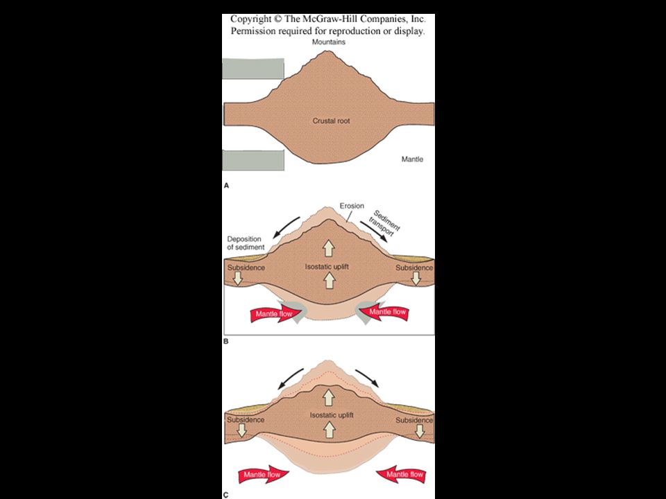
Continental crust has a thick “root”: it is thicker under mountains and thinner under lowlands (like an iceberg). This is due to isostasy (flotational balance). Continental crust is about 30-70 km thick (18 to 42 miles).
. Continental crust is about km thick (18 to 42 miles)..")
11
Figure 2.6, page 33 b. Ocean crust -Thinner than continental crust - About 5 to 10 km thick (3-6 miles)
.")
15
The ocean crust is mainly composed of pillow basalts from submarine eruptions at mid-ocean ridges (M.O.Rs.) with gabbro at depth. The ocean crust is overlain by a thin layer of sediment.

16
http://www.pmel.noaa.gov/vents/marianas/movies/rof2006/480 x360_Quicktime/NWRota_brimstone12_480.mov Pillow basalts

17
Note that Iceland sits atop the mid-Atlantic Ridge, which results in extensive volcanic eruptions of basaltic lava which cools to form the igneous rock basalt.

18
Iceland eruption, 1973

19
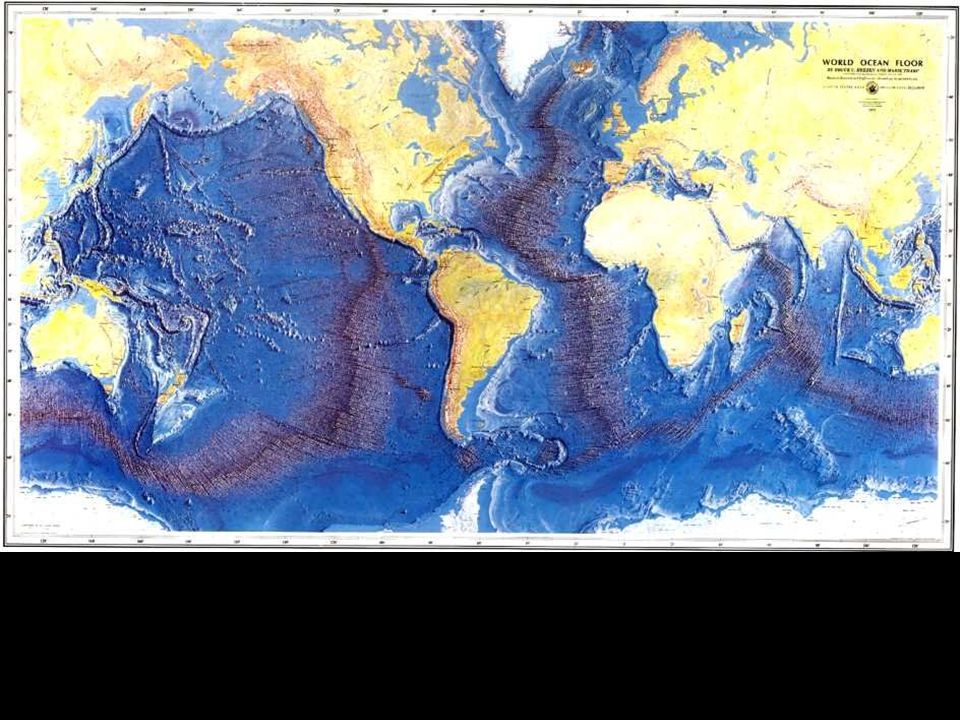
Age of the seafloor Note that the age gets older away from the mid-ocean ridges and is youngest at the ridge

21
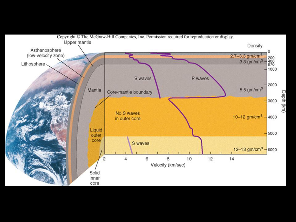
2. The Mantle - the layer below the crust - divided into 2 parts: the upper mantle and the lower mantle

22
a.The Upper Mantle - from the base of the crust to about 700 km depth - less Si, O, Al than above layers - more Fe and Mg than above layers - density = 3.3 to 5.5 g/cm 3 b. The Lower Mantle - from the base of the upper mantle to about 2900 km depth - less Si, O, Al than above layers - more Fe and Mg than above layers - density = 5.5 to 8.0 g/cm 3

23
3. The Core - rich in iron (Fe) - most dense layer of earth (10-13 g/cm 3 ) - divided into 2 parts, the outer core and inner core
 - most dense layer of earth (10-13 g/cm 3 ) - divided into 2 parts, the outer core and inner core.")
24
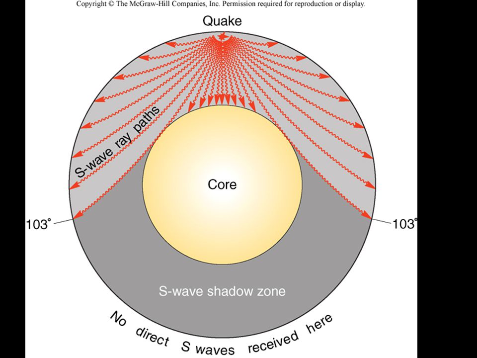
a.The Outer Core - from 2900 km to 5100 km depth - S-waves do not travel through the outer core - S-waves do not travel through liquids - therefore, the outer core is molten and behaves like a liquid - it is believed that flow of the molten outer core generates the earth’s magnetic field Fig 2.8

26
a.The Inner Core - the inner core is a solid (it’s hotter than the outer core, but the high pressure makes it solid - from 5100 km depth to: ≈ 6354 km at the poles ≈ 6378 km at the equator * spin of the earth results in an equitorial bulge Fig 2.9

28
Evidence from Seismic Waves Seismic waves or vibrations from a large earthquake (or underground nuclear test) will pass through the entire Earth Seismic reflection - the return of some waves to the surface after bouncing off a rock layer boundary –Sharp boundary between two materials of different densities will reflect seismic waves Seismic refraction - bending of seismic waves as they pass from one material to another having different seismic wave velocities
 will pass through the entire Earth Seismic reflection - the return of some waves to the surface after bouncing off a rock layer boundary –Sharp boundary between two materials of different densities will reflect seismic waves Seismic refraction - bending of seismic waves as they pass from one material to another having different seismic wave velocities")
30
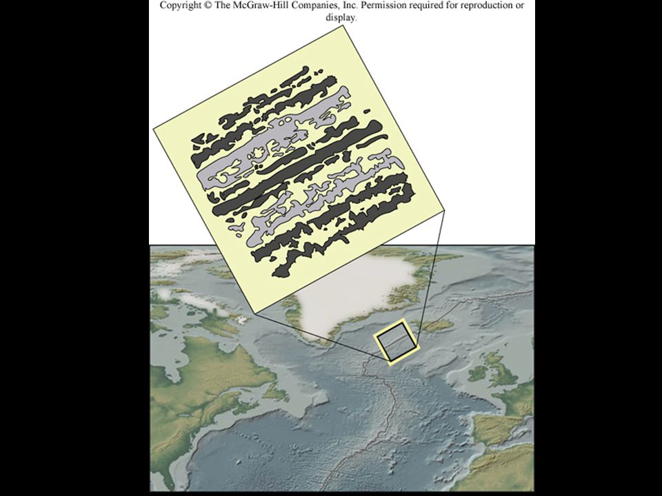
Earth’s Magnetic Field A magnetic field (region of magnetic force) surrounds the Earth –Field has north and south magnetic poles –Earth’s magnetic field is what a compass detects –Recorded by magnetic minerals (e.g., magnetite) in igneous rocks as they cool below their Curie Point Magnetic reversals - times when the poles of Earth’s magnetic field switch –Recorded in magnetic minerals –Occurred many times; timing appears chaotic –After next reversal, a compass needle will point toward the south magnetic pole Paleomagnetism - the study of ancient magnetic fields in rocks –allows reconstruction of plate motions over time
 surrounds the Earth –Field has north and south magnetic poles –Earth’s magnetic field is what a compass detects –Recorded by magnetic minerals (e.g., magnetite) in igneous rocks as they cool below their Curie Point Magnetic reversals - times when the poles of Earth’s magnetic field switch –Recorded in magnetic minerals –Occurred many times; timing appears chaotic –After next reversal, a compass needle will point toward the south magnetic pole Paleomagnetism - the study of ancient magnetic fields in rocks –allows reconstruction of plate motions over time")
Similar presentations


 *Mantle.>")