Download presentation
Presentation is loading. Please wait.

1
Mark Maddox

2
As part of its mandate to regulate the drilling and production of the oil and gas industry in Texas, the RRC maintains maps showing historical, current, and proposed well locations. In the past, manually drawn maps were used. The hardcopy maps became worn and overcrowded with handwritten data. In most cases, copies could not be made for the public because the base maps were copyrighted. 1984 - The RRC began building its computerized well location mapping system. 1994 - The base map and original Texas land survey data layers were completed. 1995 - The well data layer was completed. 1999 - The computerized mapping database was converted to ESRI Arc/Info GIS software. July 2002, the well data layer contained 1,081,409 wells and/or permitted locations with 680,634 API numbers linked to well locations in the well data layer. GIS Mapping History

3
Public GIS Map Viewer for Oil, Gas, and Pipeline Data Welcome to the RRC’s GIS MAP VIEWER. This geographic information system combines detailed information and location coordinates for oil wells, gas wells, and pipelines from the Commission's files with base map data captured from U.S. Geological Survey 7.5 minute quadrangle maps. These interactive maps were developed using Environmental Systems Research Institute, Inc. (ESRI) ArcIMS software, and interface with the Commission's Production Data Query and drilling Permit Query applications. Table of Contents: Starting on the home page. (steps 1&2) Entering GIS MAP VIEWER Click on Legend Click on Help (Check Tabs: Contents, Glossary, FAQs, County/District and Data Sources) Search by County (495 Winkler) Search by Wellbore API (495-329330) Search by Lease (Oil Lease ID # 37231, Gas ID # 224962 ) Search by Survey/Abstract (1341) Search by Places…(Lowe Windmill) Search by Pipelines (T4 Permit 04680) Search by Coordinates (Long. –102.80391 Lat. 31.9886876) Screen Pan tool Highlight Well tool Map Tools *Identify Wells: GIS Wellbore Attributes Operator/Wellbore Oil/Gas imaged Record for API & Production Data Query START UP AND STARTING UP THE GIS START UP AND SEARCH TOOLS START UP AND NAVAGATIONAL TOOLS & LAYER SEARCH
 ArcIMS software, and interface with the Commission s Production Data Query and drilling Permit Query applications. Table of Contents: Starting on the home page. (steps 1&2) Entering GIS MAP VIEWER Click on Legend Click on Help (Check Tabs: Contents, Glossary, FAQs, County/District and Data Sources) Search by County (495 Winkler) Search by Wellbore API ( ) Search by Lease (Oil Lease ID # 37231, Gas ID # ) Search by Survey/Abstract (1341) Search by Places…(Lowe Windmill) Search by Pipelines (T4 Permit 04680) Search by Coordinates (Long. – Lat ) Screen Pan tool Highlight Well tool Map Tools *Identify Wells: GIS Wellbore Attributes Operator/Wellbore Oil/Gas imaged Record for API & Production Data Query START UP AND STARTING UP THE GIS START UP AND SEARCH TOOLS START UP AND NAVAGATIONAL TOOLS & LAYER SEARCH.")
4
Logon to Commission Web site www.rrc.state.tx.us On the home page under the Commissions Info. Select Maps – Public GIS Viewer From the Public GIS Viewers (Maps) page Scroll down to the Legacy Public GIS Viewer Click Launch Legacy Public GIS Map Viewer
 page Scroll down to the Legacy Public GIS Viewer Click Launch Legacy Public GIS Map Viewer.")
5
This system provides interactive search capabilities and map views of pipeline, survey, and well location data. RRC pipeline and well location data changes daily, and the data found on this site is updated nightly. Due to the dynamic nature of this data, the pipeline and well information found on this site is not necessarily current at all times. Note: The GIS Map Viewer utilizes popup windows. Users should disable popup blocking software while using this viewer. Click on help for instructions on turning off popup blocker.

6
Click on Legend

7
Click Help Screens Click on the TAB to open window for information needed. Contents, Glossary,FAQs, County/District Table and Data. To exit click go to File and Exit.

8
SEARCH BY: County/Offshore Area/Bay On the right side of screen is where the Navigation tools are located. We will start by navigating by County. From the Go to County/Offshore Area/Bay Left click on the arrow and go down to the county needed. (Winkler) Right click on the County name.
 Right click on the County name..")
9
You will see Loading come up on the screen and then the county will appear. The county boundary is displayed as a bold Tan line, quad lines and quad names in purple, roads, cities, water, railroads and pipeline (transmission) can be seen from this distance. Note:The system will always center the selected area. County Line
 can be seen from this distance. Note:The system will always center the selected area. County Line.")
10
10 SEARCH BY: Wellbore API Number 1.In the first box enter the county FIPS.(495) (FEDERAL INFORMATION PROCESSING STANDARDS) Definition: A five digit code used by the Federal Information Processing System that uniquely identifies a state or county. 2. In the next box enter the API (32933) (American Petroleum Institute) 3. Click on arrow. Search By: Wellbore API Number 495 32933 The well will be located In the center of the map.
 (American Petroleum Institute) 3. Click on arrow. Search By: Wellbore API Number The well will be located In the center of the map..")
11
Search By: Lease/ID Click on the lease/ld box(The lease search window will popup.) Search By: Lease/ID 37231 In the Lease ID box enter the ID number 37231. (Oil is a 5-digit, Gas- 6 digit) In the District (optional) box click on the arrow and select the district number. Click the Search button.
 In the District (optional) box click on the arrow and select the district number. Click the Search button..")
12
Each well on the Oil lease will be listed. Find the well API or Well number needed (API 495-32933) Click on the “Map” box to navigate to the selected well. The well will be in the located in center of the map.
 Click on the Map box to navigate to the selected well. The well will be in the located in center of the map..")
13
From the GIS Map Viewer Click on the Lease/Id box Enter the 6 digit RRC Gas ID Number (District number is not need for Gas wells) Click Search and you will get a “Pop-Up” Click “Map” to view the Well Information. 224962 Searching by Gas Well ID

14
Searching by: Survey/Abstract 1341 1.) Click the Survey/Abstract button 2.) Click on the arrow and select the county 3.) Select the box you would like to use and enter the information (In the Abstract box type 1341) Click the Search button. 4.) Click on Map
 Click on Map.")
15
The system will navigate to the select survey (centered on the map). The survey lines are (light purple lines) with the abstract number in the lower left corner of the survey. Survey name is located in the center with section number in the upper right corner. Scale is located at the bottom of the map. SURVEY LINE ABSTRACT #
 with the abstract number in the lower left corner of the survey. Survey name is located in the center with section number in the upper right corner. Scale is located at the bottom of the map. SURVEY LINE ABSTRACT #.")
16
Searching by: Places…. Lowe Windmill 1.) Click Places You will get a “Pop-Up” 2.) Click on the arrow and select the COUNTY 3.) Select the box CATEGORY OR PLACE/NAME (and navigate to the area selected) In the Place Name box type Lowe Windmill and click Search 4.) Click on Map button
 Click Places You will get a Pop-Up 2.) Click on the arrow and select the COUNTY 3.) Select the box CATEGORY OR PLACE/NAME (and navigate to the area selected) In the Place Name box type Lowe Windmill and click Search 4.) Click on Map button.")
17
Lowe Windmill

18
Searching by: Pipelines 1.) Click Pipeline the Pipeline Data search window will “Pop-Up” 2.) Click on the county box arrow and select a County. 3.) Select the box you would like to use and enter the information (In the T4 PERMIT box enter 04680) 4.) Click the Query button. (The permit information will appear below) 5.) Click on Map The Result. 04680
 Select the box you would like to use and enter the information (In the T4 PERMIT box enter 04680) 4.) Click the Query button. (The permit information will appear below) 5.) Click on Map The Result")
20
Searching by: Coordinates 1.) Insert Lat. And Long. (Decimal Degrees Form only) 2.) Click on the arrow Note: Coordinates in the “Long:” and “Lat:” boxes will display the coordinates of the location of the cursor on the map as you move it. Long.-102.80391 Lat. 31.9886876 -102.80391 31.9886876 Searching by: Coordinates
 2.) Click on the arrow Note: Coordinates in the Long: and Lat: boxes will display the coordinates of the location of the cursor on the map as you move it. Long Lat Searching by: Coordinates.")
21
SCREEN PAN TOOLS The arrow keys may be used to move the screen in all directions. Zoom In and Zoom Out tools can be used to increase or decrease the map area without changing the center of the map area. Click “Entire State” to return to the original display.

22
Highlighting Wells 1.) Navigate to your area. Place cursor on Highlight and click on Well logs. (All of the wells that have logs will be highlighted in yellow.) Note: *Well Logs designations - yellow *High Cost Tight Sands designations - pink *High Cost Tight Sands greater than 15,000ft designations - blue *Active Commercial Disposals - orange
 Note: *Well Logs designations - yellow *High Cost Tight Sands designations - pink *High Cost Tight Sands greater than 15,000ft designations - blue *Active Commercial Disposals - orange.")
23
Orphan Wells Identify well NEW! Highlighting Wells 1.) Navigate to your area. Place cursor on Highlight and click on Orphan Wells. (All of the orphan wells will be highlighted in red.)
.")
24
NEW! Operator Cleanup Program site locations are now available! Select “Identify Operator Cleanup Site” under Map Tools, and click on a green or black triangle. You should see a pop-up box with Site identification number, name, status and location. Designations will as follows: Active Operator Cleanup Program sites – green triangle Closed Operator Cleanup Program sites – black triangle Please contact Heidi Bojes (512-475-3089) for questions regarding Operator Cleanup Program sites.Heidi Bojes Active Operator Cleanup Close Operator Cleanup
 for questions regarding Operator Cleanup Program sites.Heidi Bojes Active Operator Cleanup Close Operator Cleanup.")
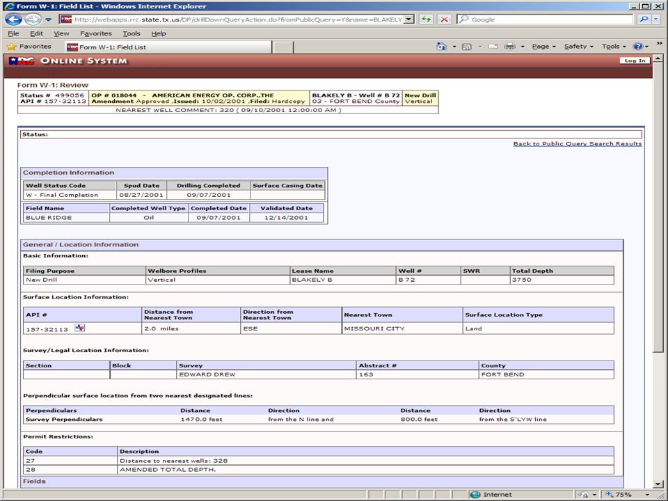
25
MAP TOOLS 1.) Navigate to your area (type in API number 157-32113) 2.) Click on the arrow 3.) Click on the Select Map Tool arrow and click on Identify wells. 4.) Place the cursor on the well spot and click. * The GIS Wellbore Attributes window will popup.
 Place the cursor on the well spot and click. * The GIS Wellbore Attributes window will popup..")
26
Click “Operator/Wellbore/PDQ”

27
From this screen you are able to access, Oil/Gas Imaged Records or Production Data Query (PDQ)
")
28
Oil/Gas Imaged Records Note: Click “POTENTIAL” to view the scanned images of well records filed for this lease.

30
Note: The Date Range can be changed to view different time periods of production. Production Data Query (PDQ)
.")
31
Note: Only wells highlighted Yellow in the GIS Map Viewer have Well Log Images attached. “Well Logs”

32
Drilling Permits

Similar presentations


.>")


