Download presentation
Presentation is loading. Please wait.

1
Census Geographies from Small to Large

2
What are the “census geographies? How are they defined? What are their characteristics? How do they relate to one another? What data is available for Census geographies? For what periods is data available? What kinds of data are available? How have census geographies changed and why do those geographies change? What resources exist for tracking down geographies, relationships and data?

3
Basic Census Geography

4
Legal/Administrative Entities

5
Statistical Entities

6
Groupings of states and the District of Columbia that subdivide the United States. There are four census regions—Northeast, Midwest, South, and West. Before 1984, the Midwest region was named the North Central region. From 1910 (when census regions were established) through the 1940s, there were three census regions—North, South, and West. Data for Regions available for Decennial Census, Economic Census, Agriculture Census Nested Geographies: Regions
 through the 1940s, there were three census regions—North, South, and West. Data for Regions available for Decennial Census, Economic Census, Agriculture Census Nested Geographies: Regions.")
7
Each of the four census regions is divided into two or more census divisions. There are nine census divisions, which the U.S. Census Bureau established in 1910. Data for Divisions available for Decennial Census, Economic Census, Agriculture Census. Nested Geographies: Divisions

8
States are the primary governmental divisions of the United States. The District of Columbia is treated as a statistical equivalent of a state for data presentation purposes. (As were American Samoa, the Commonwealth of the Northern Mariana Islands, Guam, Puerto Rico, and the Virgin Islands of the United States – in the 2000 tabulations.) Data for States available for Decennial Census, Economic Census, Agriculture Census. Nested Geographies: States
 Data for States available for Decennial Census, Economic Census, Agriculture Census. Nested Geographies: States.")
9
Census Regions and Divisions of the United States

10
The primary legal divisions of most states are termed ‘‘counties.’’ Counties in 48 States Independent Cities in 4 States Parishes in Louisiana Cities and Boroughs in Alaska Smallest consistently defined legal/administrative geography with national coverage. Data for counties available for Decennial Census, Economic Census, Agriculture Census, City/County databooks, County Business Patterns, Census of Governments, Human Area Resource Files, Criminal Justice data, Federal Outlays Nested Geographies: Counties

12
Census tracts are small, relatively permanent statistical subdivisions of a county or statistically equivalent entity. The primary purpose of census tracts is to provide a stable set of geographic units for the presentation of decennial census data. They are typically delineated by a committee of local data users. Generally, census tracts have between 2,500 and 8,000 residents and boundaries that follow visible features. When first established, census tracts are to be as homogeneous as possible with respect to population characteristics, economic status, and living conditions. The 2000 census was the first census for which the entire county was tracted. In earlier years, Block Numbering Areas (BNAs) provided sub-county geography for untracted areas. Nested Geographies: Census Tracts
 provided sub-county geography for untracted areas. Nested Geographies: Census Tracts.")
13
A census block group (BG) is a cluster of census blocks having the same first digit of their four-digit identifying numbers within a census tract. BGs generally contain between 600 and 3,000 people, with an optimum size of 1,500 people. Nested Geographies: Block Groups

14
A block is the smallest geographic unit for which the Census Bureau tabulates data. Many blocks correspond to individual city blocks bounded by streets, but blocks – especially in rural areas – may include many square miles and may have some boundaries that are not streets. A census block is an area normally bounded by visible features, such as streets, streams, and railroads, and by nonvisible features, such as the boundary of an incorporated place, county (borough or census area), or other Census 2000 tabulation entity. Census blocks typically contain around 100 persons. Tabulation blocks do not cross the boundaries of any entity for which the U.S. Census Bureau tabulated data. Nested Geographies: Blocks
, or other Census 2000 tabulation entity. Census blocks typically contain around 100 persons. Tabulation blocks do not cross the boundaries of any entity for which the U.S. Census Bureau tabulated data. Nested Geographies: Blocks.")
16
Basic Census Geography

17
Places, for the reporting of decennial census data, include census designated places (CDPs), and incorporated places. Places nest within states, but their boundaries can cross other sub-state geographies, including census tracts and BGs. Incorporated places recognized in decennial census data products are those reported to the U.S. Census Bureau as legally in existence on January 1, 2000, under the laws of their respective states, as cities, boroughs, city and boroughs, municipalities, towns, and villages. (See the GARM for a summary of state requirements for incorporated places as of 1990). No minimum or maximum size except by statute. The size of places (both in population and land area) varies dramatically: the smallest place in 1990 had population less than 10, while the largest had population greater than 7 million. Boundary changes identified from the BAS (Boundary and annexation Survey), conducted annually since 1972. Non-Nested Geographies - Place
. No minimum or maximum size except by statute. The size of places (both in population and land area) varies dramatically: the smallest place in 1990 had population less than 10, while the largest had population greater than 7 million. Boundary changes identified from the BAS (Boundary and annexation Survey), conducted annually since Non-Nested Geographies - Place.")
18
Census designated places (CDPs) are delineated for each decennial census as the statistical counterparts of incorporated places. CDPs are delineated to provide census data for concentrations of population, housing, and commercial structures that are identifiable by name but are not within an incorporated place. CDPs exist in all states. Census designated places (CDPs) are closely settled, named, unincorporated communities that generally contain a mixture of residential, commercial, and retail areas similar to those found in incorporated places of similar sizes. These communities do not have legally defined municipal boundaries or corporate powers. The Census Bureau works with local participants to delineate boundaries for CDPs. CDPs can’t be contained, in whole or part, within an incorporated place (or another CDP). Prior to 2000, CDPs had a minimum population threshold of 1000; no current minimum. Non-Nested Geographies - CDPs
 are closely settled, named, unincorporated communities that generally contain a mixture of residential, commercial, and retail areas similar to those found in incorporated places of similar sizes. These communities do not have legally defined municipal boundaries or corporate powers. The Census Bureau works with local participants to delineate boundaries for CDPs. CDPs can’t be contained, in whole or part, within an incorporated place (or another CDP). Prior to 2000, CDPs had a minimum population threshold of 1000; no current minimum. Non-Nested Geographies - CDPs.")
19
Basic Census Geography

20
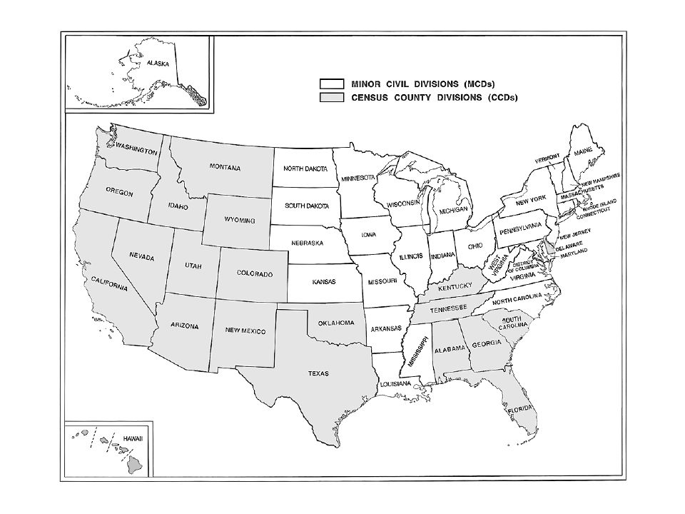
These are the primary geographic units recognized by the Census Bureau which are just below the county level. The primary distinction drawn between these subdivisions is between Minor Civil Divisions (MCDs) and Census County Divisions (CCDs). Most states have Minor Civil Divisions (MCD's) which are legally recognized governmental or administrative units. MCD's are defined in 28 states and in D.C. The specific types of MCD's vary by state. The most common type of MCD is the township, but also include towns or incorporated places, assessment districts,election districts, plantations, magisterial districts, etc. Boundary changes identified from the BAS (Boundary and annexation Survey), conducted annually since 1972. In the remaining states the Census Bureau has defined Census County Divisions (CCD's). (The types of county subdivisions by state are identified in the GARM, Table 8-2.) Non-Nested Geographies – County Subdivisions
 and Census County Divisions (CCDs). Most states have Minor Civil Divisions (MCD s) which are legally recognized governmental or administrative units. MCD s are defined in 28 states and in D.C. The specific types of MCD s vary by state. The most common type of MCD is the township, but also include towns or incorporated places, assessment districts,election districts, plantations, magisterial districts, etc. Boundary changes identified from the BAS (Boundary and annexation Survey), conducted annually since In the remaining states the Census Bureau has defined Census County Divisions (CCD s). (The types of county subdivisions by state are identified in the GARM, Table 8-2.) Non-Nested Geographies – County Subdivisions.")
21
The primary goal of delineating CCDs is to establish and maintain a set of subcounty units that have stable boundaries and recognizable names. A CCD usually represents one or more communities, trading centers or, in some instances, major land uses. It usually consists of a single geographic piece that is relatively compact in shape. The geographic "building blocks" of CCDs are census tracts, and many CCDs are groupings of several contiguous census tracts. (Although in some rural counties, two or more CCDs may next within a tract). New CCDs should have a minimum population of 1,500 persons. Some existing CCDs may have smaller populations. There is no maximum population size limit for a CCD. Each state has either all MCD's or all CCD's - there is never a split. In the geographic hierarchy these divisions provide a complete coverage of all counties in the county. There were more than 36,000 such geographic areas in the U.S. at the time of the 2000 census. Non-Nested Geographies – County Subdivisions
. New CCDs should have a minimum population of 1,500 persons. Some existing CCDs may have smaller populations. There is no maximum population size limit for a CCD. Each state has either all MCD s or all CCD s - there is never a split. In the geographic hierarchy these divisions provide a complete coverage of all counties in the county. There were more than 36,000 such geographic areas in the U.S. at the time of the 2000 census. Non-Nested Geographies – County Subdivisions.")
23
Basic Census Geography

24
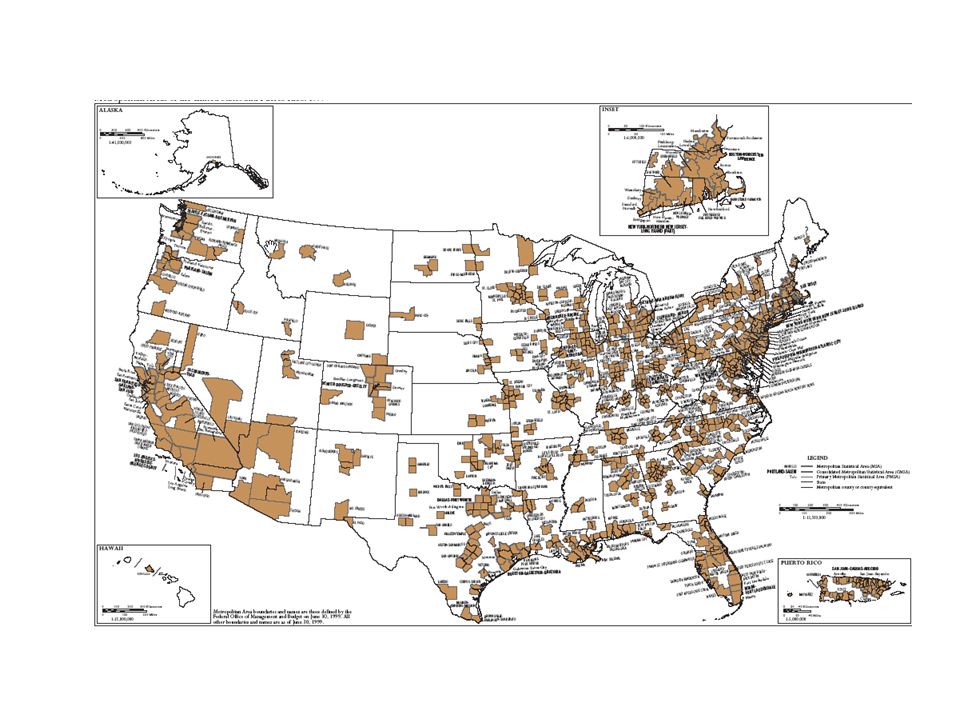
Metropolitan Areas are intended to be composed of a “core area containing a large population nucleus, together with adjacent communities that have a high degree of economic and social integration with that core”. Metropolitan Areas Metropolitan areas (as their first incarnations as SMAs) were first defined for the 1950 census, but were preceded by metropolitan districts in 1910 through 1940. These predecessors to metropolitan areas were principally defined on the the basis of population density, and were composed of aggregates of sub- county geographic units. The MAs defined in 1950 were (except in New England) composed of whole counties, and a corresponding unit – the urbanized area – was defined on the basis of population density to provide a greater distinction based on densely built up areas around the core cities. Non-Nested Geographies – Metropolitan Areas
 were first defined for the 1950 census, but were preceded by metropolitan districts in 1910 through These predecessors to metropolitan areas were principally defined on the the basis of population density, and were composed of aggregates of sub- county geographic units. The MAs defined in 1950 were (except in New England) composed of whole counties, and a corresponding unit – the urbanized area – was defined on the basis of population density to provide a greater distinction based on densely built up areas around the core cities. Non-Nested Geographies – Metropolitan Areas.")
25
The proportion of the population living in MA’s has grown substantially since they were first reported in 1950. This growth has more to do with the creation of new MA’s than with movement into existing MA’s. Percent of US Population Living in:19601970198019901998 MAs as defined in 195059.360.156.956.254.9 MAs as defined in 196063.064.462.162.461.6 MAs as defined in 197066.768.666.967.567.1 MAs as defined in 198073.275.674.875.976.0 MAs as defined in 199074.376.876.277.577.7 MAs as defined in 199880.1

26
If an area that qualifies as a metropolitan area (MA) has 1 million people or more, two or more primary metropolitan statistical areas (PMSAs) may be defined within it. Each PMSA consists of a large urbanized county or cluster of counties (cities and towns in New England) that demonstrate very strong internal economic and social links, in addition to close ties to other portions of the larger area. When PMSAs are established, the larger MA of which they are component parts is designated a consolidated Metropolitan statistical area (CMSA). CMSAs and PMSAs are established only where local governments favor such designations for a large MA. An accompanying statistical area -the micropolitan area – was implemented in 2003. A micro area contains an urban core of at least 10,000 (but less than 50,000) population. Each micro area consists of one or more counties and includes the counties containing the core urban area, as well as any adjacent counties that have a high degree of social and economic integration (as measured by commuting to work) with the urban core. The bureau has identified 578 such areas in the nation. Non-Nested Geographies – Metropolitan Areas
 that demonstrate very strong internal economic and social links, in addition to close ties to other portions of the larger area. When PMSAs are established, the larger MA of which they are component parts is designated a consolidated Metropolitan statistical area (CMSA). CMSAs and PMSAs are established only where local governments favor such designations for a large MA. An accompanying statistical area -the micropolitan area – was implemented in A micro area contains an urban core of at least 10,000 (but less than 50,000) population. Each micro area consists of one or more counties and includes the counties containing the core urban area, as well as any adjacent counties that have a high degree of social and economic integration (as measured by commuting to work) with the urban core. The bureau has identified 578 such areas in the nation. Non-Nested Geographies – Metropolitan Areas.")
29
Basic Census Geography

30
A ZIP Code tabulation area (ZCTA) is a statistical geographic entity that approximates the delivery area for a U.S. Postal Service five-digit or three-digit ZIP Code. ZCTAs are aggregations of census blocks that have the same predominant ZIP Code associated with the residential mailing addresses in the U.S. Census Bureau’s Master Address File. Three-digit ZCTA codes are applied to large contiguous areas for which the U.S. Census Bureau does not have five-digit ZIP Code information in its Master Address File. ZCTAs do not precisely depict ZIP Code delivery areas, and do not include all ZIP Codes used for mail delivery. Non-Nested Geographies – ZCTAs

31
Average ZCTA size is about 9000 in the 2000 census Data for ZIP code include Decennial Census, Economic Census, ZIP Business Patterns (http://www.census.gov/epcd/www/zipstats.html)http://www.census.gov/epcd/www/zipstats.html

32
A public use microdata area (PUMA) is a decennial census area for which the U.S. Census Bureau provides specially selected extracts of raw data from a small sample of long-form census records that are screened to protect confidentiality. These extracts are referred to as ‘‘public use microdata sample (PUMS)’’ files. For Census 2000, two two types of PUMAs were delineated within states. PUMAs of one type comprise areas that contain at least 100,000 people. The PUMS files for these PUMAs contain a 5-percent sample of the long-form records. The other type of PUMAs, super-PUMAs, comprise areas of at least 400,000 people. The sample size is 1 percent for the PUMS files for super-PUMAs. PUMAs cannot be in more than one state or statistically quivalent entity. The larger 1-percent PUMAs are aggregations of the smaller 5- percent PUMAs. PUMAs of both types, wherever the population size criteria permit, comprise areas that are entirely within or outside metropolitan areas or the central cities of metropolitan areas. Non-Nested Geographies – PUMAs
’’ files. For Census 2000, two two types of PUMAs were delineated within states. PUMAs of one type comprise areas that contain at least 100,000 people. The PUMS files for these PUMAs contain a 5-percent sample of the long-form records. The other type of PUMAs, super-PUMAs, comprise areas of at least 400,000 people. The sample size is 1 percent for the PUMS files for super-PUMAs. PUMAs cannot be in more than one state or statistically quivalent entity. The larger 1-percent PUMAs are aggregations of the smaller 5- percent PUMAs. PUMAs of both types, wherever the population size criteria permit, comprise areas that are entirely within or outside metropolitan areas or the central cities of metropolitan areas. Non-Nested Geographies – PUMAs.")
33
The geographies associated with Public Use Microdata Samples (PUMS) differ from census to census and, within census, by the type of sample. Examples: 1970: 6 samples, State, Metro (250K), Neighborhood 1980: State, Metro (100K) samples 1990: State, Metro (100K) samples Non-Nested Geographies – PUMAs
, Neighborhood 1980: State, Metro (100K) samples 1990: State, Metro (100K) samples Non-Nested Geographies – PUMAs.")
35
Some Key Points to Remember Census Geographies include nested and non-nested geographies Some geographies defined politically, others for statistical and reporting purposes Geographies range in size from a block to the nation as a whole, but different sorts of data available depending on type of geography

36
Generalized extracts of TIGER data for use in Geographic Information Systems For most levels of tabulation geography File Formats: –ArcView shapefiles (*.shp) –ARC/INFO Export (*.e00) –ARC/INFO Ungenerate (ASCII) Available Now on the Internet: www.census.gov/geo/www/cob/index.html Boundary Files
 –ARC/INFO Export (*.e00) –ARC/INFO Ungenerate (ASCII) Available Now on the Internet: Boundary Files")
37
Boundary files available at the Census Bureau Alaska Native Regional Corporations: 2000 American Indian Areas/Alaska Native Areas/Hawaiian Home Lands: 2000 | 1990 American Indian Tribal Subdivisions: 2000 Census Block Groups: 2000 | 1990 Census Divisions: 2000 Census Regions: 2000 Census Tracts: 2000 | 1990 Congressional Districts: 109th | 108th | 107th | 106th | 105th | 104th | 103rd Consolidated Cities: 2000 County and County Equivalent Areas: 2000 | 1990 County Subdivisions: 2000 | 1990 Incorporated Places/Census Designated Places: 2000 | 1998 | 1990 Metropolitan Areas: 1999 | 1998 | 1996 | 1990 New England County Metropolitan Areas: 20002000 19902000 19902000 1990109th108th107th106th105th104th103rd2000 19902000199020001998199019991998199619902000

38
Boundary files available at the Census Bureau Oregon Urban Growth Areas: 2000 Public Use Microdata Areas - 1 Percent: 2000 Public Use Microdata Areas - 5 Percent: 2000 School Districts - Elementary: 2000 School Districts - Secondary: 2000 School Districts - Unified: 2000 State and State Equivalent Areas: 2000 | 1990 State Legislative Districts - Lower/House: 2000 State Legislative Districts - Upper/Senate: 2000 Subbarrios (Puerto Rico Only): 2000 Traffic Analysis Zones: 2000 Tribal Block Groups: 2000 Tribal Census Tracts: 2000 Urban Areas: 2000 | 1990 Voting Districts: 2000 3-Digit ZIP Code Tabulation Areas (ZCTAs): 2000 5-Digit ZIP Code Tabulation Areas (ZCTAs): 20002000 19902000 19902000
: 2000 Traffic Analysis Zones: 2000 Tribal Block Groups: 2000 Tribal Census Tracts: 2000 Urban Areas: 2000 | 1990 Voting Districts: Digit ZIP Code Tabulation Areas (ZCTAs): Digit ZIP Code Tabulation Areas (ZCTAs):")
39
Geospatial Data – TIGER Built for the 1990 Census Improvements for 2010: MTAIP (MAF/TIGER Accuracy Improvement Project) -Scope Focused on improving horizontal positional accuracy for streets in TIGER to 7.6 m or better Enables the use of GPS technology to record structure locations in the field, which in turn improves accuracy and efficiency in tabulating 2010 Census responses
 -Scope Focused on improving horizontal positional accuracy for streets in TIGER to 7.6 m or better Enables the use of GPS technology to record structure locations in the field, which in turn improves accuracy and efficiency in tabulating 2010 Census responses")
Similar presentations


 Files American Community Survey (ACS) Microdata Files Metropolitan.>")


 U.S. Census Bureau Geography Division & National Processing Center.>")


 2005 Data Release.>")


