Download presentation
Presentation is loading. Please wait.

1
NAM Rime Factor and Ice Accumulation Rate Faye Barthold — HMT Meteorologist Mike Bodner — DTB November 4, 2009

2
What is rime factor? Defined as the total growth of ice by vapor deposition and accretion divided by the growth of ice by vapor deposition alone –Indicates the amount of riming present on an individual ice particle Derived directly from the model’s microphysics scheme –Currently available in the NAM (Ferrier microphysics) only
 only.")
3
Rime Factor 1.0 >1 to ~2 ~2 to ~4 ~4 to ~8 ~8 to ~40 >40 Hydrometeor Type Unrimed snow Lightly rimed snow Moderately rimed snow Heavily rimed snow GraupelSleet Snowflake images from: http://www.its.caltech.edu/~atomic/snowcrystals/

4
Ice Accumulation Rate Can derive an “ice accumulation rate” in inches per hour using rime factor value in the lowest layer of the model –Median point between the surface and the interface with the next layer Combines snow and precipitation ice Does not give information about freezing rain rates

5
Ice Accumulation Rate Algorithm depends on an assumption of a maximum possible snow to liquid ratio Where: IAR = ice accumulation rate PRATE = precipitation rate POFP = percent of frozen precipitation DR = density ratio FRIME = rime factor

6
Ice Accumulation Rate Assuming a 30:1 maximum snow to liquid ratio Assuming a 20:1 maximum snow to liquid ratio Assuming a 10:1 maximum snow to liquid ratio

7
Limitations Doesn’t take ground temperature or surface heat flux into account Accumulation rates will always increase as the assigned snow to liquid ratio increases –Model doesn’t make any decision about whether a given snow to liquid ratio is realistic Instantaneous value only—doesn’t capture what happens at intermediate time steps Based on NAM QPF, temperature profile, etc. –If NAM sounding and temperature forecasts are questionable, rime factor and ice accumulation rate forecasts will also be questionable

8
Cases Used CoCoRaHS new snow reports to determine usefulness of ice accumulation rate output –October 2008—northern Rockies snowstorm –December 2008—eastern U.S. mixed precipitation event –January 2009—southern plains to northeast US winter storm

9
October 2008 Early season mountain snow event Snowfall totals (maximum observed) State Snow (in) Montana49 Wyoming33 North Dakota 11 South Dakota 12 Idaho15 Utah11
 State Snow (in) Montana49 Wyoming33 North Dakota 11 South Dakota 12 Idaho15 Utah11")
11
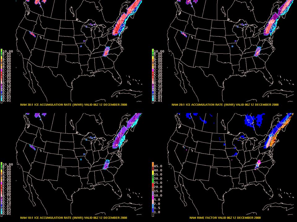
30:120:110:1

14
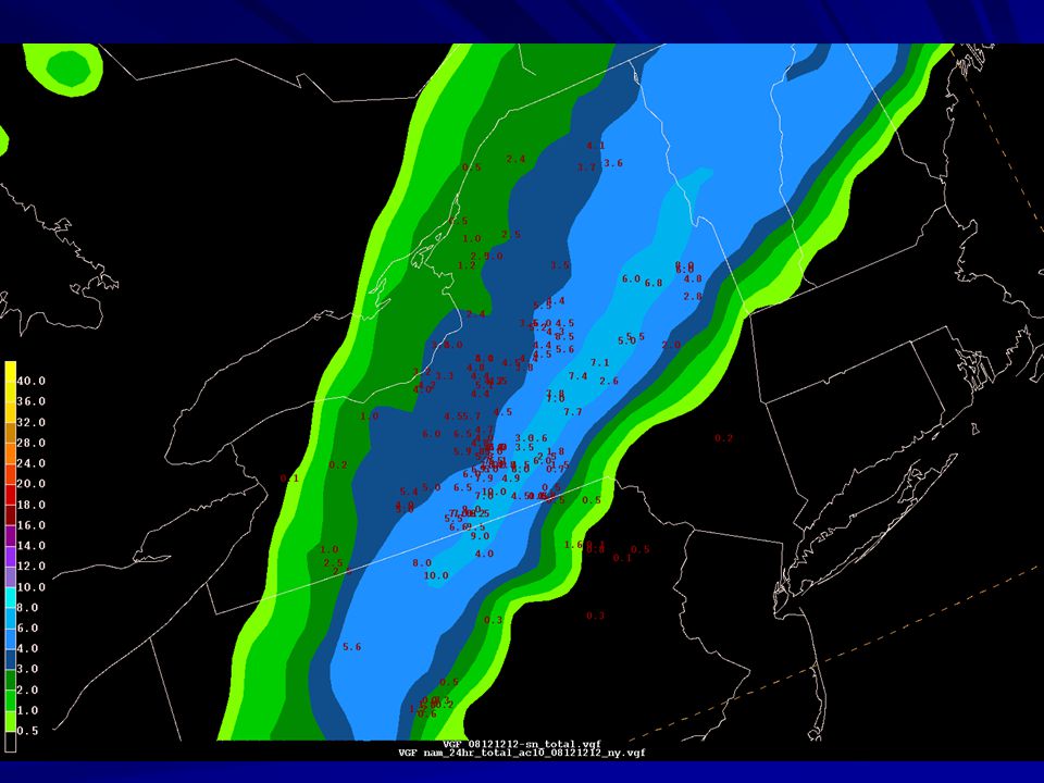
December 2008 East coast mixed precipitation event Snowfall totals (maximum observed) State Snow (in) Texas5 Louisiana8 Mississippi8 Kentucky6.5 Pennsylvania10 New York 9 Vermont9 Maine2
 State Snow (in) Texas5 Louisiana8 Mississippi8 Kentucky6.5 Pennsylvania10 New York 9 Vermont9 Maine2")
16
30:120:110:1

20
30:120:110:1

24
How can this tool improve forecasts? More objective way to estimate snowfall accumulations –Uses cloud physics parameters, surface and vertical temperature data –No QPF conversion required Accumulation rates can be used to indicate intensity Better indication of event duration, thus providing better guidance for advisory/warning issuance

Similar presentations


 Great Lakes Operational Meteorological Workshop Dan Petersen, Wallace.>")

>")


 Hydrometeorlogical Prediction Center (HPC) Forecast Operations Branch Winter Weather Desk Dan Petersen.>")


