Download presentation
Presentation is loading. Please wait.

1
Legal Descriptions and Site Plan Requirements
Chapter 14 Legal Descriptions and Site Plan Requirements

2
Introduction Virtually every piece of property in the U.S. is described for legal purposes Legal descriptions Every one is unique and cannot be confused with any other property Filed in local jurisdictions, generally county or parish courthouses Public records and can be reviewed at any time

3
Introduction (cont’d.)
Site (i.e., plot or lot) Area of land generally one plot or lot in size Plat Map of part of a city or township showing some specific area
 Area of land generally one plot or lot in size. Plat. Map of part of a city or township showing some specific area.")
4
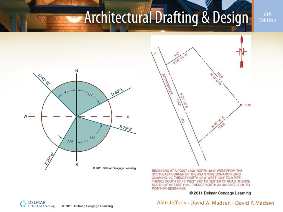
Metes and Bounds Systems
Metes and bounds identify property perimeters Metes are measurements Bounds are boundaries Also established through bearings (e.g., directions with reference to 1 quadrant of the compass) Metes and bounds land survey begins with the point of beginning (POB)
 Metes and bounds land survey begins with the point of beginning (POB)")
6
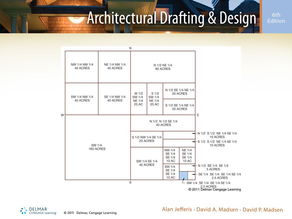
Rectangular Survey System
Great land survey Lines of latitude (i.e., parallels, baselines) Imaginary parallel lines running east and west Lines of longitude (i.e., meridians, principle meridians) Imaginary lines running north and south
 Imaginary parallel lines running east and west. Lines of longitude (i.e., meridians, principle meridians) Imaginary lines running north and south.")
7
Rectangular Survey System (cont’d.)
Great land survey (cont’d.) Townships Numbered by tiers running north–south Six miles square Sections Divided areas into units One mile square
 Townships. Numbered by tiers running north–south. Six miles square. Sections. Divided areas into units. One mile square.")
12
Lot and Block System Legal description system
Results from metes and bounds or rectangular system

13
Site Plan Requirements
Site plan (e.g., plot or lot plan) Map of a piece of land that can be used for any number of purposes Proposed construction Topography with contour lines Grading plans
 Map of a piece of land that can be used for any number of purposes. Proposed construction. Topography with contour lines. Grading plans.")
14
Site Plan Requirements (cont’d.)
Site plan functions: Legal property description based on a survey Property line bearings and directions North arrow Roads and easements Utilities Elevations Map scale

15
Topography Physical description of land surface
Shows variation in elevation, known as relief, and locating other features

16
Drawing Site Plans Typically include: Site plan scale
Legal description of the property Property line bearings and dimensions North arrow Existing and proposed roads and structures Driveways, patios, walks, and parking areas Public or private water supply

17
Drawing Site Plans (cont’d.)
Typically include (cont’d.): Public or private sewage disposal Location of utilities Rain and footing drains and storm sewers or drainage Topography and setbacks Items on adjacent properties Existing and proposed trees
: Public or private sewage disposal. Location of utilities. Rain and footing drains and storm sewers or drainage. Topography and setbacks. Items on adjacent properties. Existing and proposed trees.")
18
Grading Plan Features Show existing and proposed topography

19
Site Analysis Plan Basis for proper design relationship of development to site and adjacent properties

20
Subdivision Plans Local requirements for subdivisions should be confirmed Some areas have guidelines

21
Planned Unit Development

22
Metrics in Site Planning
Recommended metric values used in design and drafting of site plans Refer to table provided in the chapter

Similar presentations


. The Public Land Survey System (PLSS) was developed by the Continental Congress to replace the common practice of describing.>")


