Download presentation
Presentation is loading. Please wait.

1
OneGeology An overview Ian Jackson 25 April 2008 OneGeology Secretariat British Geological Survey

2
Thank you International OneGeology team

3
Contents of this presentation Basics of OneGeology Where is OneGeology now? OneGeology-Europe OneGeology at the 33 IGC Profile and PR

4
OneGeology basics OneGeology is a project to make web- accessible the best available geological map data worldwide at a scale of about 1:1 million, as a Geological Survey contribution to the International Year of Planet Earth 2008

5
Feb Mar Apr May Jun Jul Aug Sep Oct Nov Dec Jan Feb Mar Apr May Jun Jul Aug Sep Oct Nov Dec Jan Feb Mar Apr 20062007 2008 Just an idea Brighton, UK International project established

6
The objectives Make existing geological map data accessible –in whatever digital format is available in the participating country Transfer know-how to those who need it Adopt an approach that recognizes that different nations have differing abilities to participate Stimulate a rapid increase in interoperability (ie disseminate GeoSciML further and faster)
")
7
A crucial point OneGeology is about geological data available in a standard data structure first, i.e. making geological map data accessible without geological reconciliation The prime objective is not about harmonising geological units and scientific classification across frontiers – thats something for the longer term

8
The Brighton Accord 81 participants from 43 nations and 53 national and international bodies Agreed OneGeology should proceed Mission: improve the accessibility of global, regional and national geological map data & increase usefulness to society Focus on making accessible existing geological map coverage Recognise that this will catalyse scientific harmonisation of map data globally. Geological Surveys to work together to develop interchange standard to make their data interoperable Progress to be presented at the International Geological Congress in Oslo in 2008

9
Where OneGeology is now

10
80 countries

11
99 participating Surveys and organisations

12
Progress in last 17 months Worldwide interest in OneGeology worldwide - resulting in new recruits and support Dynamic and well-used web site Prototype OneGeology portal developed Cookbooks available OneGeology-Europe proposal to EC; related proposal sent to USA NSF International governance issues progressed - IPR, funding, future corporate structure etc IGC33 Launch and events in preparation

13
Web site

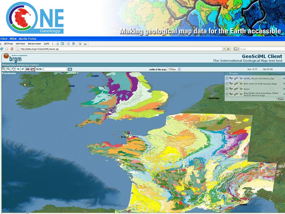
14
Prototype Portal

17
Cookbooks A manual to explain from first principles how to put your geological map data on the web (as WMS) WFS Cookbook will follow
 WFS Cookbook will follow")
18
OneGeology-Europe 3.25 million, 21 nation, 30 partner proposal to EC Takes OneGeology much further in EU Member States Accelerating the work on interoperability and data specification Enhancing with higher resolution data and applied data access in several areas Will see Europe play a leading role globally in development of a geoscience/environmental spatial data infrastructure (ESDI)
")
19
OneGeology-Europe – major objectives make existing digital geological spatial data more easily accessible (i.e. contribute to OneGeology) make a significant contribution to the progress of INSPIRE – i.e. develop systems and protocols to better enable the discovery, viewing, downloading and sharing of core European spatial geological data. demonstrate best practice examples of the delivery and application of geological spatial data in the public and private sectors.
 make a significant contribution to the progress of INSPIRE – i.e. develop systems and protocols to better enable the discovery, viewing, downloading and sharing of core European spatial geological data. demonstrate best practice examples of the delivery and application of geological spatial data in the public and private sectors..")
20
OneGeology-Europe data provider and consortium member OneGeology data provider OneGeology-Europe coverage

21
OneGeology-Europe 10 Results and Deliverables interoperable geology spatial dataset at 1:1 million scale for all onshore EU scientific and informatics specification for the harmonisation of geological data at this resolution; progress towards a harmonised dataset view service providing access to best practice high resolution geological spatial data services for 6 Member States 2-4 pilot and case studies on cross-border delivery of harmonised high resolution data access multilingual discovery metadata for all participants geological and applied map data

22
OneGeology-Europe 10 Results and Deliverables robust data model, schema and mark-up language for the geosciences web portal providing easy multilingual access to the above data and examples of user-focused web services best practice examples of the delivery of geological data to a range of users guidance and code of practice on licencing and clearing arrangements facilitating re-use of geological spatial data exchange of science, technology, informatics and communication skills and experience across the EU and globally.

23
OneGeology-Europe Latest News 29 January - Very positive evaluation received from the EC (84% score) 26 February - Revised proposal submitted for 3.25million (2.6million from EC) 10 April - EC invited project leaders to a negotiation meeting to answer final questions, discuss detail and prepare Grant Agreement Project will probably go ahead in September 2008!
 26 February - Revised proposal submitted for 3.25million (2.6million from EC) 10 April - EC invited project leaders to a negotiation meeting to answer final questions, discuss detail and prepare Grant Agreement Project will probably go ahead in September 2008!")
24
OneGeology at the 33 rd International Geological Congress, Oslo Formal launch at IGC Opening Ceremony Full day symposium Help desk and technical clinic Booth and demo at IGC exhibition

25
Profile and PR

26
At the IYPE global launch in Paris

27
And TV……. Italian TV

28
Like to know more? www.onegeology.org

Similar presentations

 ETSI Seminar SEM08-14.>")


>")


 ICC Conference Santiago, Chile 15-21.>")


