Download presentation
Presentation is loading. Please wait.

1
Geocoder Web Service for the Metro Geocoder Web Service for the Metro Area Nancy Read Metro. Mosquito Control District nancread@mmcd.org MetroGIS Policy Board, January 27, 2010

2
Geocoder Background – how it works Update Addition – Landmarks – –Parks, Schools, City Halls, …

3
Text string Location coordinates Metro Counties Govt. Center 2099 University Ave. W 44.959665 ° St. Paul, MN 55104-93.187222 ° Coordinates used to put point on map: Geocoder

4
Text string Location coordinates 2099 University Ave. W 44.959665 ° St. Paul, MN 55104-93.187222 ° Match Street Name Interpolate along Range Address – Streets File 2001 2201 University Ave. W 2099

5
Text string Location coordinates 2099 University Ave. W 44.959665 ° St. Paul, MN 55104-93.187222 ° Match a Point Address – Parcel Points 2001UniversityAve. W 2099 + University Ave W 2099UniversityAve. W2151UniversityAve. W

6
Text string Location coordinates Metro Counties Govt. Center 2099 University Ave. W 44.959665 ° St. Paul, MN 55104-93.187222 ° Match a Point Point of Interest / Landmark BakerElem.School Text match Metro CountiesGovt. Center McDonalds

7
Geocoder: 3 Parts Data Format Accuracy Up-to-date Abbreviations Spelling errors

8
Geocoder Parts Match, Score Data ST = Street ST = Saint Geocoder Engine Standardizers Comparison Settings Weights Rules

9
Geocoder Parts Web Service Match, Score Data ST = Street ST = Saint Input, Output formats

10
Why build a geocoder service? Use point data as well as interpolated Local data more current, Better Unlimited use, no fees or license issues Complex tool, only build once One data set to update

11
MetroGIS Geocoder Project 2007 - MetroGIS project funding 2007 - MetroGIS project funding Dave Bitner (MAC) Dave Bitner (MAC) Jim Maxwell (TLG) Jim Maxwell (TLG) Mark Kotz (Met.Co.) Mark Kotz (Met.Co.) Gordy Chinander (MESB) Gordy Chinander (MESB) Bob Basques (St. Paul) Bob Basques (St. Paul) Chris Cialek, Jim Dickerson & Pete Olson (LMIC) Chris Cialek, Jim Dickerson & Pete Olson (LMIC) Kent Treichel (MN Dept. of Revenue) Kent Treichel (MN Dept. of Revenue) Nancy Read (MMCD)- Project Manager Nancy Read (MMCD)- Project Manager
 Bob Basques (St. Paul) Chris Cialek, Jim Dickerson & Pete Olson (LMIC) Chris Cialek, Jim Dickerson & Pete Olson (LMIC) Kent Treichel (MN Dept. of Revenue) Kent Treichel (MN Dept. of Revenue) Nancy Read (MMCD)- Project Manager Nancy Read (MMCD)- Project Manager.")
12
MetroGIS Geocoder Project PAGC open source geocoder PAGC open source geocoder –reworked from batch to multi-user –created code for a service –has community of interested developers

13
Set up service with Metro data Set up service with Metro data –TLG Streets –7-county Parcel Layer (centroids) –Address Points (as available) House + Street or Intersection House + Street or Intersection Host Host –MnGEO (Minnesota Geographic Information Office) MetroGIS Geocoder Project
 –Address Points (as available) House + Street or Intersection House + Street or Intersection Host Host –MnGEO (Minnesota Geographic Information Office) MetroGIS Geocoder Project")
14
Metro Geocoder Up continuously since June 2008 Up continuously since June 2008 Automated data update Automated data update Streets – weekly from NCompass (TLG) Parcels – quarterly from MetroGIS/ Met. Council (as provided by counties) Usage 10,000 – 90,000 hits per month Usage 10,000 – 90,000 hits per month
 Usage 10,000 – 90,000 hits per month Usage 10,000 – 90,000 hits per month.")
16
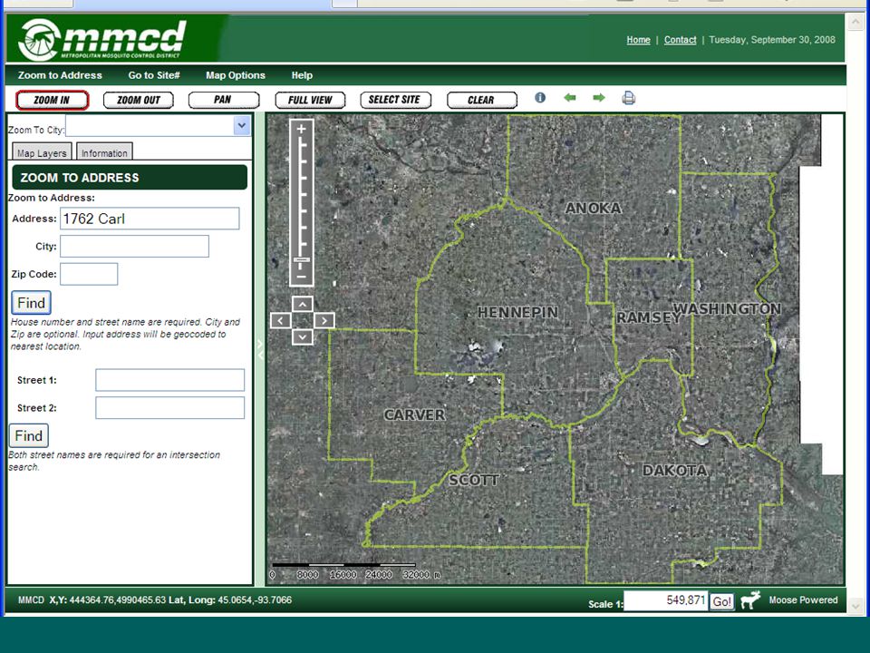
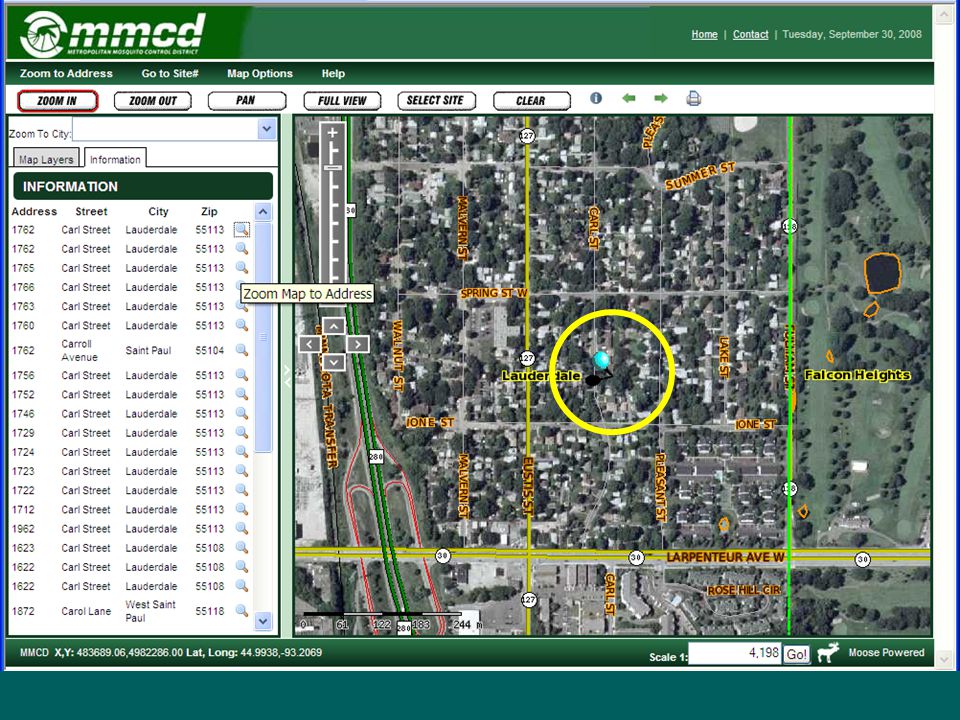
Tools, Docs, Users Sample form - try address, see responses Sample form - try address, see responses Technical documents Technical documents –Geocoder Request Protocol documentation Geocoder Request Protocol documentationGeocoder Request Protocol documentation –Geocoder Response API documentation Geocoder Response API documentationGeocoder Response API documentation SOAP wrapper for.Net (Matt McGuire, Metro Council) SOAP wrapper for.Net (Matt McGuire, Metro Council) ArcMap Tool (Steve Jakala, Scott Co.) ArcMap Tool (Steve Jakala, Scott Co.) Public sites using Geocoder Web Service: Public sites using Geocoder Web Service: –Metro Mosquito Control web map (Houston Engineering) –DNR LandView (Craig Perrault, MnDNR) –Carver County
 SOAP wrapper for.Net (Matt McGuire, Metro Council) ArcMap Tool (Steve Jakala, Scott Co.) ArcMap Tool (Steve Jakala, Scott Co.) Public sites using Geocoder Web Service: Public sites using Geocoder Web Service: –Metro Mosquito Control web map (Houston Engineering) –DNR LandView (Craig Perrault, MnDNR) –Carver County")
17
Using Geocoder in Applications Web Service takes urlencoded Address or Intersection requests Web Service takes urlencoded Address or Intersection requests returns closest matches with latitude- longitude, in XML, CSV or JSON. returns closest matches with latitude- longitude, in XML, CSV or JSON.

18
Example Request http://geoserver.state.mn.us/geocoder/geocode_response? methodName=GeocodeRequest &Version=1.1 &CountryCode=US &maximumResponses=10 &CompleteAddressNumber=2099 &CompleteStreetName=UNIVERSITY%20AVE%20W &PlaceName=Saint%20Paul &ZipCode=55104%203431 &ResponseFormat=XML

19
Response (xml) …. …. -- - - - - - - - - - - - - 2099 2099 -- UNIVERSITY - UNIVERSITY - AVENUE WEST AVENUE WEST SAINT PAUL SAINT PAUL 55104 55104 3431 3431 -- -93.186111 44.959949 - -93.186111 44.959949 - -- parcels_all7_points_lat83_point - parcels_all7_points_lat83_point - 123-332923220025 123-332923220025

22
Geocode by Intersection

24
Call Tracking application Geocode while customer is on the phone Geocode while customer is on the phone

25
Assigns Service Area uses st_within PostGIS SQL function with lat,long from geocoder service to populate other fields from spatial tables uses st_within PostGIS SQL function with lat,long from geocoder service to populate other fields from spatial tables

26
Field staff select their calls, map

27
Geocoding calls reduced time field staff spend locating call by 80% North service area calls, 2008

28
How well is Geocoder working? Web Service Match, Score Data Inputs, parsing Separate fields or one string Geocoder Engine Standardizers Comparison Settings Weights Rules Point or Ranges Loc. Accuracy Current Parsing Abbreviations Free of spelling errors Strange but true PAGC ST = Street ST = Saint

29
How well is Geocoder working? Web Service Match, Score Data Inputs, parsing Separate fields or one string Geocoder Engine Standardizers Comparison Settings Weights Rules Point or Ranges Loc. Accuracy Current Parsing Abbreviations Free of spelling errors Strange but true PAGC ST = Street ST = Saint

30
How well is Geocoder working? Web Service Match, Score Data Inputs, parsing Separate fields or one string Geocoder Engine Standardizers Comparison Settings Weights Rules Point or Ranges Loc. Accuracy Current Parsing Abbreviations Free of spelling errors Strange but true PAGC ST = Street ST = Saint

31
Points of Interest / Landmarks Change match/scoring engine (PAGC) – –International interest – some areas do not use house numbers + street name addressing – –Scores based on Each (significant) word Soundex Approximate (whole name) Web Service Match, Score Data
 – –International interest – some areas do not use house numbers + street name addressing – –Scores based on Each (significant) word Soundex Approximate (whole name) Web Service Match, Score Data")
32
One service handles address, intersection, and named feature Change web service inputs allowed – –LandmarkName, LandmarkType, CountyName Web Service Match, Score Data Points of Interest / Landmarks

33
Try data file with x,y (not shp file) Data available? Web Service Match, Score Data Points of Interest / Landmarks

34
Data GNIS – Geographic Names, USGS NCompass / TLG Landmarks – –Part of MetroGIS streets package – –Some points, some polygon centroids (water) Metro. Council – –Transit, from bus route requests – –Other data? 911 – –Each Public Service Answering Point (PSAP) has their own data HSIP + state creation/update CAP grant – –Hospitals, Fire Stations, Police, Schools Commercial data sources?
 has their own data HSIP + state creation/update CAP grant – –Hospitals, Fire Stations, Police, Schools Commercial data sources .")
35
Data: examples

36
TLG

37
Data: examples GNIS

38
Data: examples Transit

39
Data: examples

40
Data Data for testing: TLG Landmarks Could assemble a more complete dataset – –Eliminate duplicates – –Check positional accuracy – –Check spelling and consistency – –Feature types? Data maintenance??

41
Points of Interest / Landmark Example of raw output - - - - - - - EAST BETHEL CITY HALL D65A ANOKA EAST BETHEL MINNESOTA -- 45.371203 -93.214304 -- clipped_to_metro2_lat_point - - - - BETHEL CITY HALL D65A ANOKA BETHEL MINNESOTA - 45.404547 -93.269909 - clipped_to_metro2_lat_point - EAST BETHEL ICE ARENA D67 ANOKA EAST BETHEL MINNESOTA - 45.344766 -93.234857 - clipped_to_metro2_lat_point

42
Geocoder Enhancements Change candidate matches returned – alt. street names before alternate numbers Fix corrected names returned with pre-types (no County Road County Road B) Allow entry of House # + Street Name as continuous text string
 Allow entry of House # + Street Name as continuous text string.")
43
MetroGIS Geocoder Project Continuing Work – –Address points dataset, with automated data update – –Adjusting performance – –More Hosts? Batch service? – –Open source – anyone can contribute to code Web Service – Contacts List ? Outreach ?

Similar presentations


 geocoding Problems and solutions Street map sources Polygon geocoding.>")

