Download presentation
Presentation is loading. Please wait.

1
Geospatial Metadata, Standards and Infrastructure
GIS for Spatial Planning Training for Ministry of Transport Mozambique Maputo, Mozambique 2-13 July 2018 GeoInformation Systmes Section (GISS)
")
2
Module 2: Geospatial Metadata, Standards and Infrastructure

3
What is metadata?

4
What is metadata? Data about data.

5
What is metadata? Data about data. Description Item Map documents
Layers Geodatabase datasets Non-spatial table etc.

6
What is metadata? A set of data that describes and gives information about other data (item).
.")
7
What is metadata? In an item's metadata you can record:
How accurate the item is Restrictions associated with using and sharing Important processes Etc.

8
Use of metadata? Finding data Using data Re-using data

9
Essential metadata vocabulary
Metadata elements: An individual piece of information in an item's metadata. Metadata standard: A document identifying content that should be provided to describe geospatial resources such as maps, map services, vector data, imagery, and relevant nonspatial resources. Standards are typically created or ratified by national or international standards bodies.

10
Essential metadata vocabulary
Metadata profile: A document that modifies a metadata standard. A profile may reduce the overall number of metadata elements that were originally included in a standard. Metadata style: The metadata configuration used in ArcGIS. The appearance of metadata when you view it in ArcGIS.

11
Essential metadata vocabulary
Stand-alone metadata: An XML file containing geospatial metadata that is not associated with an ArcGIS item. Some items, such as atlases and globes, can't be described in ArcGIS. Metadata catalog: A searchable online collection of metadata describing geospatial resources.

12
Metadata styles and standards
A metadata style configures ArcGIS to create the metadata you want. ArcGIS provides the default Item Description metadata style which lets you see and edit a simple set of metadata properties for an item.

13
Metadata styles and standards
Default Item Description metadata style is designed to facilitate providing information that is used by ArcGIS. It is straightforward and effective, suitable for anyone who doesn't need to adhere to specific metadata standards.

14
Metadata styles and standards
Several metadata styles are provided with the current version of ArcGIS for Desktop to support different metadata standards: ISO Metadata Implementation Specification : Geographic information — Metadata — XML schema implementation ISO Metadata Implementation Specification GML3.2: identical to the one above, except the exported files use the GML 3.2 namespace North American Profile of ISO : This style lets you view and edit a complete metadata document that complies with North American Profile of ISO 19115:2003

15
Metadata styles and standards
INSPIRE Metadata Directive: This style lets you view and edit a complete ISO metadata document that adheres to the INSPIRE Implementing Rules. FGDC CSDGM Metadata: This style lets you view and edit metadata following the FGDC Content Standard for Digital Geospatial Metadata (CSDGM) guidelines.
 guidelines.")
16
Viewing metadata Most ArcGIS items can have metadata, including tools, toolboxes, folders, geodatabases, text files, and file types such as Word documents. Once created, metadata is copied, moved, and deleted along with the item when it is managed with ArcGIS.

17
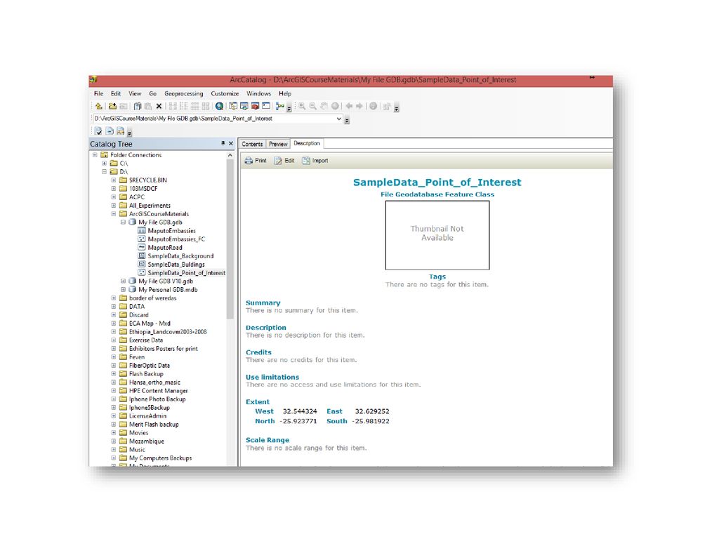
Viewing metadata An ArcGIS item's metadata can be viewed in the Description tab.

19
Viewing metadata After viewing an item's metadata, you can start editing it if you have permission to do so—you'll see the Edit button in the Description tab.

20
Viewing metadata Default Item Description metadata style

21
Choosing a metadata style

22
Choosing a metadata style

23
Choosing a metadata style
ISO Metadata Implementation Specification

24
Choosing a metadata style
Elements are classified as mandatory, recommended or optional. Mandatory elements have to be filled in. Recommended element implies a strong recommendation. Optional element is everything else. Some of these elements will be of substantial interest to give a good description of a dataset.

25
Creating and editing metadata
Example of FGDC metadata standard

26
Creating and editing metadata
Example of FGDC metadata standard

27
Creating and editing metadata

29
Creating and editing metadata

30
Creating and editing metadata

32
Creating and editing metadata

38
Creating standard-compliant metadata

39
Creating standard-compliant metadata

40
Printing metadata

41
THANK YOU!

Similar presentations


 732-7188 GIS and Mapping Procedures in ArcMap 9.x Creating an ArcMap Project Editing an ArcMap Project Printing an ArcMap Project.>")


