Download presentation
Presentation is loading. Please wait.

1
Evolution of the Contemporary Political Map

2
Territoriality – a country's sense of property and attachment toward its territory, as expressed by its determination to keep it inviolable and strongly defended Sovereignty – final authority over social, economic, and political matters should rest with the legitimate rulers of independent states

3
Europe – Beginning of the modern state 1648 – Peace of Westphalia – Treaty that ended the Thirty Year’s War in Europe – Recognized statehood, nationhood, clearly defined borders – View of territory as fixed – Idea spread to entire world by 1900

4
Europe – Beginning of the modern state Nationalism 1. People have loyalty to the nation and a belief in the nation 2. Government promotes the nation that coincides with the borders – Can build a single national identity out of divergent people

5
19 th Century European Nationalism Brought together people with shared cultural characteristics – Ex – Germany, Italy (see atlas p.84) Led to separatist movements – Ex – Ireland, Norway, Poland
 Led to separatist movements – Ex – Ireland, Norway, Poland")
6
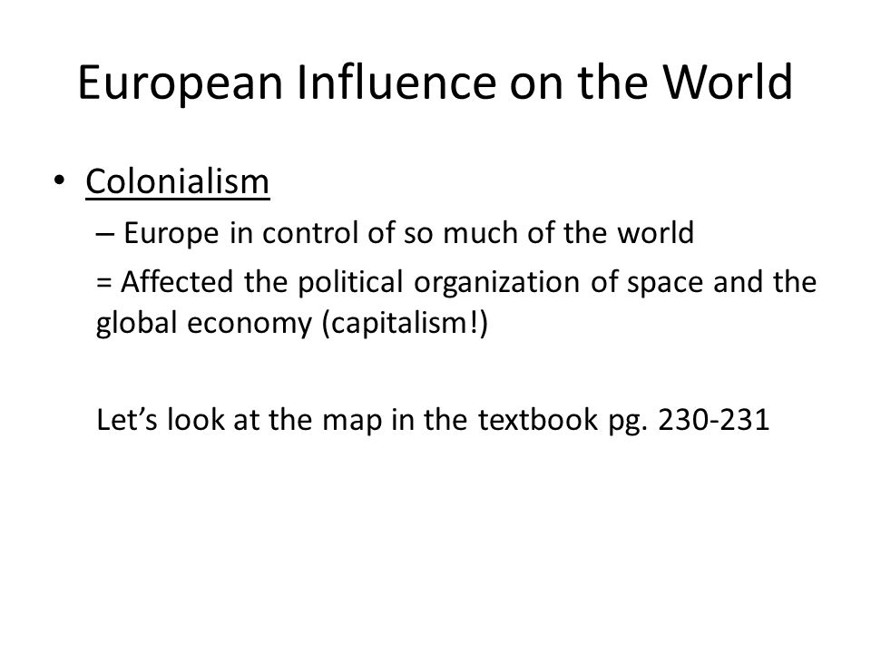
European Influence on the World Colonialism – Europe in control of so much of the world = Affected the political organization of space and the global economy (capitalism!) Let’s look at the map in the textbook pg. 230-231
7
European Influence on the World Let’s look at the atlas now: – Pg. 82-83: Overseas Empires – What parts of the world were colonized in the first wave? – Pg. 84 (top): compare this map to a modern map of Europe – What’s different? What’s the same? – Pg. 88-89: Latin America What states were created out of former Spanish territory? Describe Mexico’s borders in 1821 compared to today
: compare this map to a modern map of Europe – What’s different. What’s the same. – Pg : Latin America What states were created out of former Spanish territory. Describe Mexico’s borders in 1821 compared to today.")
8
European Influence on the World 1 st Wave of colonialism – Plantations, exploited Africa for slave labor, wealth through sugar, coffee, fruit, cotton – Characterized by conquest, plunder, slavery, and annihilation of indigenous people

9
European Influence on the World 2 nd Wave of colonialism – After Industrial Revolution, cheap labor and raw materials

10
European Influence on Africa Berlin Conference of 1884-1885: A meeting held by the major powers in Europe to end disputes, answer questions and divide up the land of Africa The result was a hodgepodge of geometric boundaries that divided Africa into fifty irregular countries—largely ignoring ethnic differences

11
Effects: – Europeans ignored Africa’s existing states, ethnic groups, and natural environments – Countries left landlocked Ethnic Diversity Map

12
European Influence on Africa When colonies became independent, gaining legal status of sovereign state was easy; economic independence was impossible

13
Effects of Colonialism The concentration of wealth that colonialism brought to Europe (and parts dominated by European settlers such as the U.S., Canada, and Australia) is at the heart of the highly uneven global distribution of power we still have today.
 is at the heart of the highly uneven global distribution of power we still have today.")
14
To understand any state, we must also understand its spatial and functional relationships within the world economy

15
Wallerstein’s World Systems Theory 1. The world-economy has one market and a global division of labor 2. Although the world has multiple states, almost everything takes place within the context of the world economy 3. The world economy has a three-tier structure

16
Wallerstein’s World Systems Theory The three-tier structure of the world economy – Use page 233 to identify the core, periphery, and semi-periphery – Define each of these categories in the key

17
Warm-up: Thursday Look at your map representing Wallerstein’s World Systems Theory to answer the following questions: 1. List 3 countries that make up the core. 2. What are the characteristics of the core countries? 3. What are the characteristics of the periphery countries?

18
Warm-up: Friday - Write down 2 observations

19
Law of the Sea http://donutholes.ch http://www.britannica.com/topic/Law-of-the- Sea http://www.britannica.com/topic/Law-of-the- Sea

21
China-Taiwan Divide http://www.bbc.com/news/world-asia- 34729538 http://www.bbc.com/news/world-asia- 34729538

22
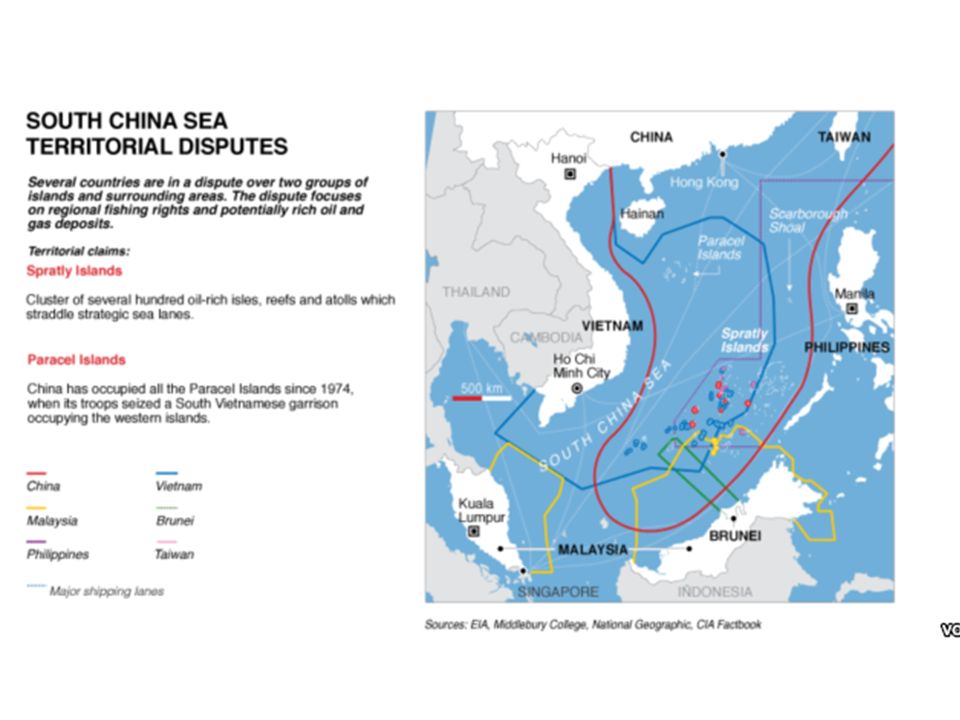
Border Disputes http://io9.gizmodo.com/10-territorial- disputes-that-mean-your-maps-are-already- 1679513142 http://io9.gizmodo.com/10-territorial- disputes-that-mean-your-maps-are-already- 1679513142

23
Warm-up: Monday Without looking at anything, what words would you use to describe “geopolitics”?

24
GEOPOLITICS Interplay among geography, power, politics, and international relations Considers the strategic value of land and sea area in the context of national economic and military power and ambitions

25
GEOPOLITICS Jigsaw Organic Theory Heartland Theory Rimland Theory Domino Theory

26
Warm-up: Tuesday Kahoot! Review of Geopolitical theories

27
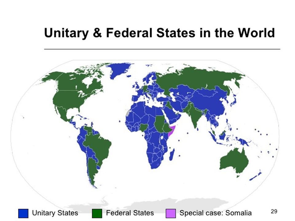
Forms of Government: Unitary One central government controls everything Power is not shared between states or provinces majority of countries today

28
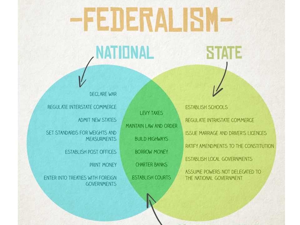
Form of Government: Federal sovereign state where power is shared between the central (federal) government and the units of the federation (at least two). Therefore, there are two levels of governance in the federal state, the central and the regional, each of which has specific powers (legislative, executive and judicial) granted to them by the Federal Constitution.
 granted to them by the Federal Constitution..")
32
Territorial Morphology

33
Compact State - efficient circular, oval, or rectangular A politico-geographic term to describe a state that possesses a circular, oval, or rectangular territory in which the distance from the center to any point on the boundary exhibits little variation easy to govern Relatively easy to govern Cambodia Cambodia, Uruguay, and Poland are examples CAMBODIA Shapes of States

34
Elongated State – potential isolation long and narrow A state whose territory is decidedly long and narrow; its length is at least six times greater than its average width Difficulties with transportation and communications; often high regionalism VietnamGambia, Laos Chile, Vietnam, Gambia, and Laos are classic examples. VIETNAM

35
Protruded (prorupted) State – access or disruption Protruded (prorupted) State – access or disruption Shapes of States narrow, elongated land extension A type of territorial shape that exhibits a narrow, elongated land extension leading away from the main body of the territory protrusion ‘protrusion’ is often peripheral from the core with differing culture and economy ThailandMyanmar Thailand and Myanmar are leading examples THAILAND
 State – access or disruption Protruded (prorupted) State – access or disruption Shapes of States narrow, elongated land extension A type of territorial shape that exhibits a narrow, elongated land extension leading away from the main body of the territory protrusion ‘protrusion’ is often peripheral from the core with differing culture and economy ThailandMyanmar Thailand and Myanmar are leading examples THAILAND")
36
Shapes of States Perforated State – South Africa Completely surrounded the territory of other states ‘hole’ exists within A ‘hole’ exists within the state’s territorial extent Access to the outside Access to the outside world is difficult for the ‘hole’ state – needs to be on friendly terms with the ‘perforated’ state South Africa South Africa is an excellent example (Lesotho and Swaziland are the ‘holes’) Other examples?
 Other examples")
37
Shapes of States Fragmented State - Problematic several separated parts A state whose territory consists of several separated parts, not a contiguous whole isolated The individual parts may be isolated from each other by the land area of other states or by international waters Separation Separation is a challenge to communications and transportation; high regionalism PhilippinesIndonesia Philippines and Indonesia are also examples. MALAYSIA

38
Warm-up: Wednesday What do you see? 1 2 3 4

39
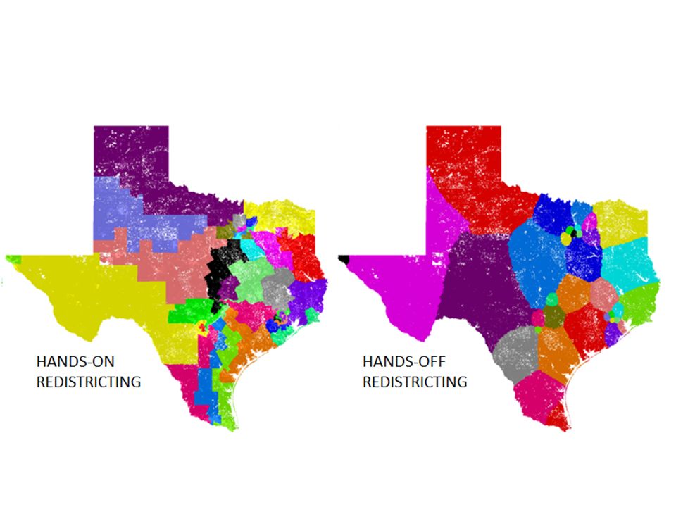
What are legislative district boundaries? Why are legislative district boundaries redrawn? San Antonio City Council: http://www.sanantonio.gov/Council/FindMyCou ncilMember.aspx http://www.sanantonio.gov/Council/FindMyCou ncilMember.aspx Census explanation: https://www.census.gov/geo/maps- data/data/aboutcd.html https://www.census.gov/geo/maps- data/data/aboutcd.html

40
Watch the video … What is your opinion of this parody? https://www.youtube.com/watch?v=- zMqxdNUDOo https://www.youtube.com/watch?v=- zMqxdNUDOo

41
Voting districts, redistricting, and gerrymandering influence the results of elections at various scales.

43
Gerrymandering visualized: https://www.washingtonpost.com/news/won k/wp/2015/03/01/this-is-the-best- explanation-of-gerrymandering-you-will-ever- see/ https://www.washingtonpost.com/news/won k/wp/2015/03/01/this-is-the-best- explanation-of-gerrymandering-you-will-ever- see/ Gerrymandering parody: https://www.youtube.com/watch?v=- zMqxdNUDOo https://www.youtube.com/watch?v=- zMqxdNUDOo

44
FRQ – 2015 #1 Complete the FRQ with a partner … Be prepared to share your response

46
Warm-up: Monday Create one or more memory devices to help you learn the countries of Europe. Be prepared to share!

47
Let’s finish talking about the EU Review what we covered … Finish presenting … Article about the future of the EU

48
Warm-up: Tuesday Kahoot! Europe map review …

49
Devolution process whereby regions within a state demand and gain political strength and growing autonomy at the expense of the central government (e.g., Basque and Catalonia in Spain, Chechnya in Russia, …). The breakdown of a state into smaller political units

50
Examples of Devolution in Europe Break up of a state Yugoslavia/ Balkans Former U.S.S.R. Czechoslovakia Austria-Hungary Demand for autonomy UK: Scotland, Wales, Ireland, N. Ireland Spain: Basques, Catalonians France: Corsica

51
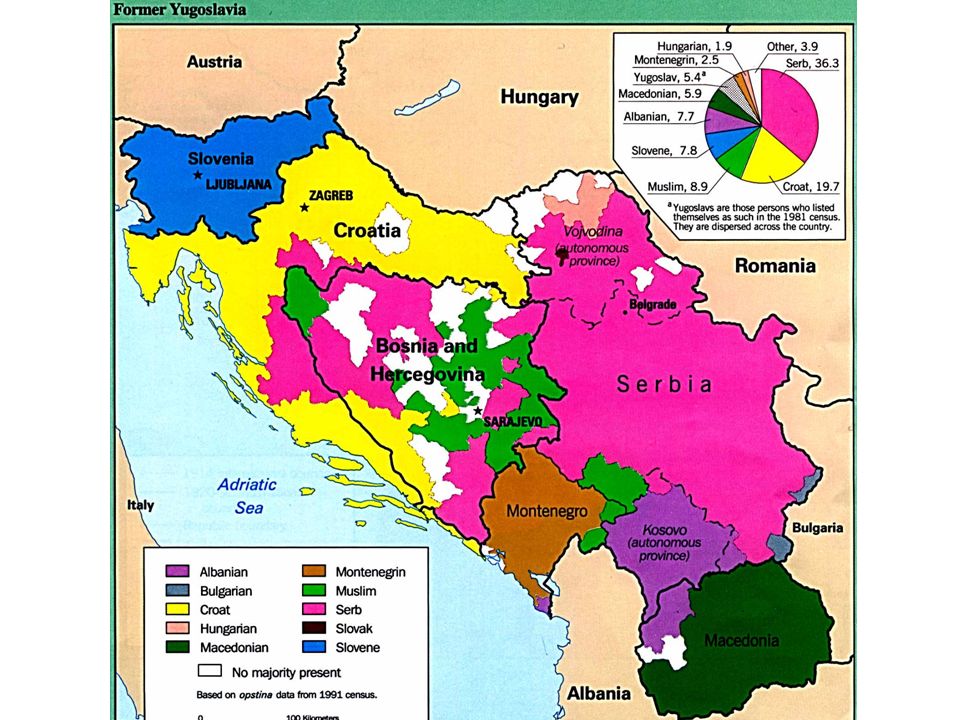
Balkanization - geopolitical term, originally used to describe the process of fragmentation or division of a region or state into smaller regions or states that are often hostile or uncooperative with one another.

53
Former Yugoslavia Yugoslavia was created as a multi-ethnic state at end of WWI to unite all South Slavic speakers Relative peace under Josep Tito 1953-1980 “Yugoslavia has seven neighbors, six republics, five nationalities, four languages, three religions, two alphabets, and one dinar.” Balkanization in 1990s: wars and ethnic cleansing broke country into Slovenia, Croatia, Serbia, Montenegro, Macedonia, and Bosnia & Herzegovina - border disputes Kosovo declared independence from Serbia in 2008

54
Former Soviet Union

56
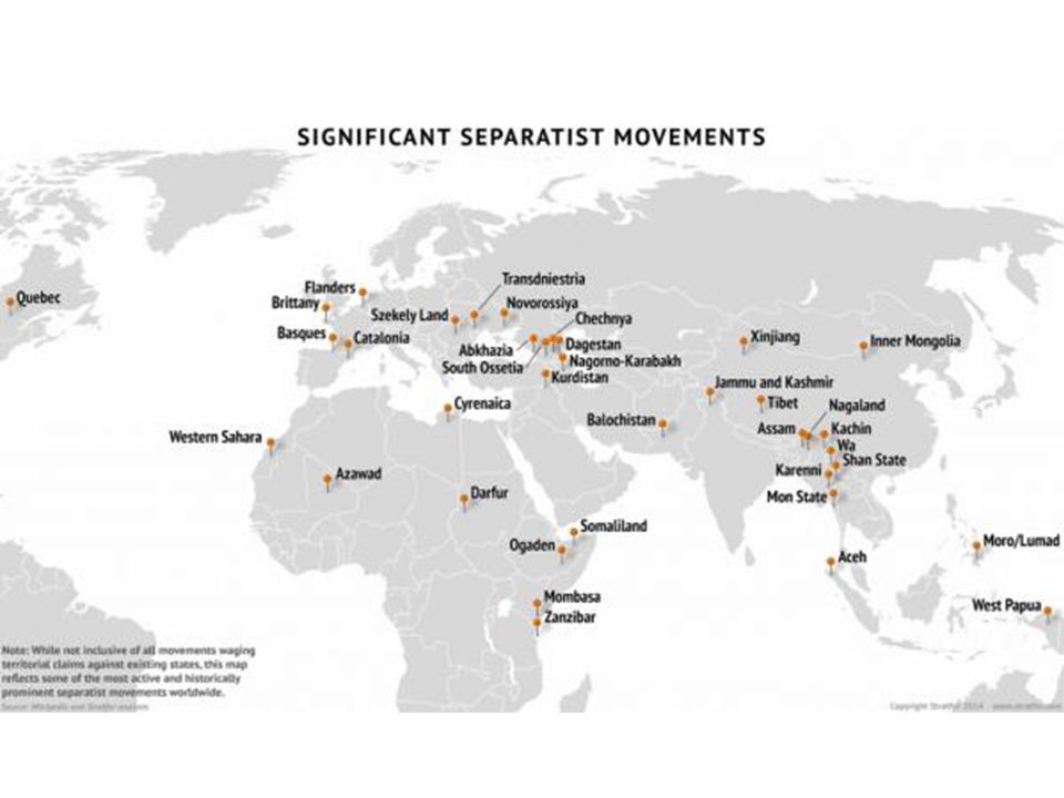
http://www.zerohedge.com/news/2014-09- 24/nation-dividing-mapping-worlds- significant-separatist-movements http://www.zerohedge.com/news/2014-09- 24/nation-dividing-mapping-worlds- significant-separatist-movements https://www.stratfor.com/weekly/centripetal- and-centrifugal-forces-work-nation-state https://www.stratfor.com/weekly/centripetal- and-centrifugal-forces-work-nation-state

57
Devolution in the United States?

58
FRQ

59
Supranationalism vs. Devolution http://srmsgeographyrecord.weebly.com/uplo ads/1/3/4/3/13437016/supranationalism.pdf http://srmsgeographyrecord.weebly.com/uplo ads/1/3/4/3/13437016/supranationalism.pdf

60
Warm-up: Thursday Kahoot! Europe map Review

61
Centripetal force – forces that unify a state – national culture, shared ideological objectives, common faith,… Centrifugal force – forces that divide a state – internal religious, political, economic, linguistic, or ethnic differences

62
Fragile States Index http://library.fundforpeace.org/library/fragiles tatesindex-2015.pdf http://library.fundforpeace.org/library/fragiles tatesindex-2015.pdf Use the information to answer the analysis questions.

63
https://apmodels.wikispaces.com/Political+Ge ography https://apmodels.wikispaces.com/Political+Ge ography

64
Scoop.it Political Geo http://www.scoop.it/t/geography- education?tag=unit+4+political http://www.scoop.it/t/geography- education?tag=unit+4+political

Similar presentations


>")


 100 State Shapes 100 Geopolitical Theories States and Nations.>")


