Download presentation
Presentation is loading. Please wait.

1
Geography The Lay of the Land

2
The Maya homeland, called Mesoamerica, spans five countries: Mexico, Guatemala, Belize, Honduras, and El Salvador. There are now indications that the people we call the Maya had migrated from North America to the highlands of Guatemala perhaps as long ago as 2600 BCE, living an agricultural, village-based life.

3
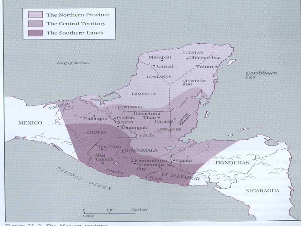
By the time Maya civilization had reached its peak ( CE) - the Maya were spread across an almost continuous territory of roughly 311,000 square kilometers (120,000 square miles), comprising three general areas:
 - the Maya were spread across an almost continuous territory of roughly 311,000 square kilometers (120,000 square miles), comprising three general areas:")
5
The Rainforests The tropical rain forest of the lowlands, stretching from northwestern Honduras, through the Petén region of Guatemala and into Belize and the Chiapas. This became the heart of Classic Maya civilization and included cities such as Copán, Yaxchilán, Tikal, and Palenque.

6
Apart from the volcanic glacier mountains, most of Mesoamerica is covered by a dense rain forest.
A rain forest resembles a greenhouse, providing warmth, sunlight, and water, and producing an enormous variety of plants. Unlike the rich humus soils of temperate-zone forests, the soil in rain forests is thin and poor. In order to survive, tropical trees and plants have developed highly efficient root systems that absorb nutrients from dead plants (which decompose rapidly because of the high heat and humidity) before they are washed away.
 before they are washed away.")
7
The Highlands The Guatemala highlands and the Pacific Coast, where Aztec influence in the early Classic period caused some differences in cultural development from the Central, or Lowlands, Maya.

8
The Peninsula The northern Yucatán peninsula, whose sites include Labná, Chichen Itzá and Uxmal, is characterized by scrub vegetation, thin soil, and little surface water. After the lowlands city-states collapsed, ending the Classic period, there was increased migration into the Yucatán and Maya culture continued to thrive there until the arrival of the militaristic Toltecs.

9
River Systems A series of rivers originates in the mountains and flows towards the Pacific Ocean on the west coast, and towards the Gulf of Mexico in the southern Petén lowlands. These rivers served as passageways for canoes to travel from one city to another. Most of the Maya cities of the Classic period were built near rivers that provided water for human consumption and access to trade routes. In the northern Yucatán lowlands, however, there are no major rivers.

10
The Soil The best soils are found in the southern highland valleys where volcanic eruptions have enriched the earth. The spring-like climate and fertile valleys made this a popular place to settle, despite the threat of volcanoes. Today, this area supports the largest Maya population.

11
While the Mayan-speaking peoples spread across these regions shared many similarities, their geographical dispersal resulted in the evolution of numerous languages which are related but sufficiently distinctive to prevent different Maya groups today from understanding one another. This divergence adds a further complication to efforts to translate the hieroglyphic writing of the city-states. Scholars today are still trying to reconstruct the family tree of the Mayan languages and there are different interpretations, but it is generally felt that four or five language groups had emerged by the Middle Preclassic period ( BCE).
.")
Similar presentations