Download presentation
Presentation is loading. Please wait.

1
Coping with hazards and disasters Khishma Modoosoodun 26 October 2015

2
OUTLINE 1.AMESD wave data buoy 2.MESA wave and surge monitoring 3.MESA SADC THEMA on flood 4.MESA coastal monitoring 5.Tsunami Inundation map for Mauritius

3
1.AMESD wave data buoy Data: Near-Real Time wave data (30 min-interval) transmitted to MMS used to validate forecasting models. Period: 2012-2014 End-users: fishermen venturing at sea

4
1.AMESD wave data buoy Communication Hardware Communication Hardware PC Buoy Data Monitoring/Presentati on Software Database Central Repository Communication Software Data Visualisation via Web-based Interface Configuration Software Satellite/GSM/Radio Communication Receiving Station

5
2.MESA wave and surge monitoring Acquire operational marine information to allow monitoring, evaluation, prevision and mitigation of ocean risks. Setting up of a small network of wave buoys - IOC Member states

6
2.MESA wave and surge monitoring

7
3.MESA SADC THEMA on flood The MESA SADC Flood Service is designed to assist help the ministries and departments of water resources and disaster management offices mandated with flood monitoring and disaster management in SADC Member States monitoring. Active participation of the MOI in the set up of the SADC flood service in Mauritius

8
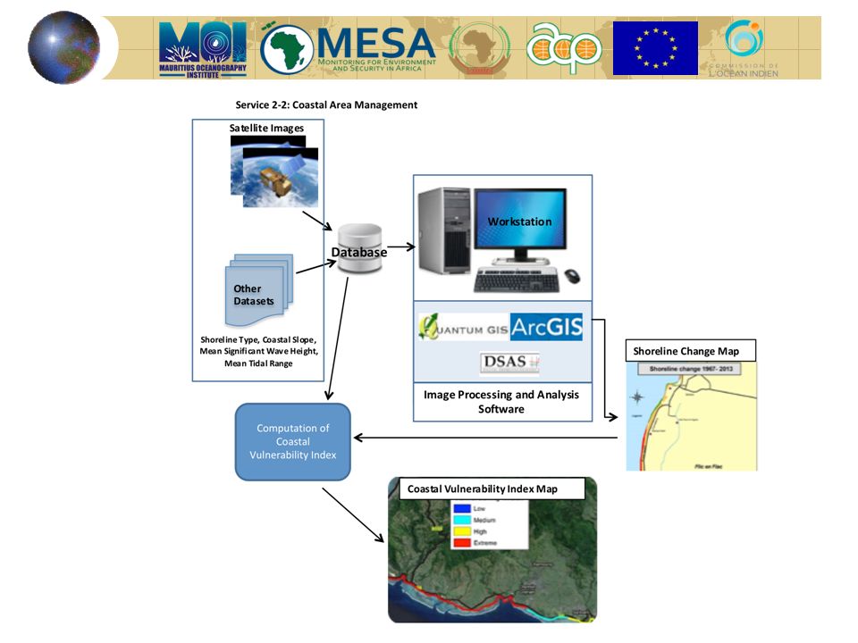
Acquisition of satellite/aerial images Digitalise aerial photos Geo-reference and rectify images using GIS software Calculating shoreline change Acquisition of satellite/aerial images Digitalize aerial photos Geo-reference and rectify images using GIS software Calculating shoreline change 4.Shoreline Change Determining the Coastal Vulnerability Index (CVI)
")
10
Eventual CVI Output Rough example for the coast of Mauritius Identify sites more prone to coastal hazard Shortlist affected sites Come up with a monitoring protocol to generate maps of shoreline changes

11
5.Tsunami Inundation map for NDRRMC The MOI has had an active participation in the setting up of an early warning system for Mauritius. In 2007, MOI came up with a Tsunami preparedness map for the National Disaster Risk Reduction Management Centre.

12
Thank you… Contact: Mr. Bheenesh Motah bmotah@moi.intnet.mu Dr. Daniel Marie director@moi.intnet.mu https://s-media-cache- ak0.pinimg.com/originals/3f/5a/52/3f5a527646b64c78a 893ea6f589f2ee6.gif

13
IOC THEMA Countries: Comoros, Kenya, Madagascar, Mauritius, Mozambique, Reunion Island, Seychelles and Tanzania Determining the Coastal Vulnerability Index Variables Shoreline type Shoreline change Rate Coastal Slope Mean tidal Range

Similar presentations


 Participatory governance and regional partnerships for effective implementation 5 th Caribbean CDM Conference:>")


 2012 Mark Merrifield University of Hawaii Requirements Status Strategies Partnerships Emerging technologies.>")

