Download presentation
Presentation is loading. Please wait.

1
Site Selection Analysis Lincoln Property Company Paula Dzuck University of Texas at Dallas Final Presentation: GIS Workshop Summer 2004 July 28, 2004

2
Introduction Lincoln Property Company (LPC) is one of the largest, private real estate service firms for both residential and commercial management within the United States. Currently, LPC manages over 300 hundred properties in the U.S. and 40 properties in Dallas. Objective: the purpose of this research project was to evaluate if Lincoln Property Company is taking advantage of potential land area or areas for multi-family housing development within the city of Dallas?

3
Problem Statement Decisions about land development, construction issues, and property take-overs are typically made by analyzing rough numbers from Excel spreadsheets, graphics such as pie chart as well as digital ortho maps displays of current properties on conference room walls. There is a “technological drag” within this company. It is very difficult to incorporate “new” and/or “emerging” technologies. With that in mind, there is obviously a lack of spatial perspective due to the current methods of site selection.

4
Literature Review Time is buy is still now…banks are more eager to lend money for land development at relatively low interest rates. There has been a recent influx of multi-family housing development within the city of Dallas. Development is still occurring at a rapid rate that thorough assessment of the given land is not being fulfilled. Webb, S. (2003). Oversupply Hinders Multifamily Recovery [Electronic version]. National Real Estate Investor. Retrieved May 27, 2004, from http://nreionline.com/microsites Author Unknown (1996). New apartment report makes strong case for renting [Electronic version]. National Real Estate Investor. Retrieved May 27, 2004, from http://nreionline.com/microsites
. Oversupply Hinders Multifamily Recovery [Electronic version]. National Real Estate Investor. Retrieved May 27, 2004, from Author Unknown (1996). New apartment report makes strong case for renting [Electronic version]. National Real Estate Investor. Retrieved May 27, 2004, from")
5
Data Sources Data was obtained for this project from the following sources: LPC Properties: addresses inputted into a table and geocoded North Central Texas Council of Governments Dallas County shapefile, rivers, railroads, freeways etc. University of Texas at Dallas, Green lab (3.206, P drive) Dallas Landmark data: schools, hospitals and shopping centers DCAD and Dallas County Parcel data obtained from Dr. Curtin FEMA: Federal Emergency Management Agency Q3 flood shapefile for Dallas County obtained from Dr. Curtin
 Dallas Landmark data: schools, hospitals and shopping centers DCAD and Dallas County Parcel data obtained from Dr. Curtin FEMA: Federal Emergency Management Agency Q3 flood shapefile for Dallas County obtained from Dr. Curtin.")
6
Analysis…background When searching for an apartment home, each individual has a different set of objectives that needs to be fulfilled. Hence, there is not a universal method of analysis when trying to select the “perfect” site location to construct multi-family housing. From an LPC standpoint, my own expertise in the industry as well as personal observation, in Dallas, proximity is the key. It is an important factor when living in this city. People here want to live close to things. Ex: “Looking for an apartment near my children’s school.” etc. With the city of Dallas in mind, there is a lot of parcels close to many things….where to begin?

7
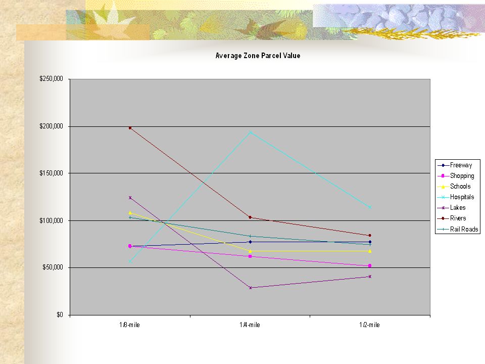
Analysis Tried to find some spatial relationship between parcel values and proximity to given features. Created a 1/8-mile, ¼-mile and ½-mile zone buffer around each feature. Within each zone-buffer, obtained the average market parcel value. GOAL: establish within what proximity range to start the analysis process.

8
Analysis Select Best Location Freeways Shopping Schools Hospitals Lakes Rivers Rails Airports 1/8 -mile ¼-mile ½-mile 1/8 -mile ¼-mile ½-mile 1/8 -mile ¼-mile ½-mile 1/8 -mile ¼-mile ½-mile 1/8 -mile ¼-mile ½-mile 1/8 -mile ¼-mile ½-mile 1/8 -mile ¼-mile ½-mile 1/8 -mile ¼-mile ½-mile

9
Parcel Values 1/8-mile¼-mile½-mile Freeway $72,710$77,300 Shopping $72,900$62,350$52,200 Schools $108,400$67,600$67,650 Hospitals $52,200$193,800$113,850 Lakes $123,900$28,900$40,450 Rivers $198,250$103,060$84,300 Rail Road $103,400$83,600$74,400 Airports $1,350,000$705,850$272,050

11
Analysis Majority of the features’ average parcel zone value decreased the further away from the feature itself, which still did not provide a solid basis for choosing any zone-buffer. Taking it one step further…created a proximity-weighted model, following the AHP method, in order to assist in the process of determining the best location for multi-family housing development. The Analytical Hierarchy Process is a systematic method when comparing and contrasting numerous variables and the alternatives associated with those specific variables. STEP 1- pair wise comparison matrix showing preferences for the three buffer zones for each feature. Result of this step was to establish zone-buffer priority (8 values).
..")
12
Analysis Results from STEP1: Zone-buffer priority for each feature Freeways½-mile zone-buffer Shopping½-mile zone-buffer Schools ½-mile zone-buffer Hospitals 1/8-mile zone-buffer Lakes ¼-mile zone-buffer Rivers ½-mile zone-buffer Rail Roads½-mile zone-buffer Airports½-mile zone-buffer STEP 2: Pair wise comparison matrix for 8 features based on the total parcel-zoned values for all three buffer zones. (EX: All three zones for Shopping Center equaled to $187,450.) The outcome of STEP 2 is establish the overall priorities (8 values). STEP 3: Develop overall priority ranking by each value derived in STEP 1 and multiple by each value obtained in STEP 2 for each zone-buffer. And last, added the 8 values together resulting in the three final weighted values, one final value for each buffer-zone. FINAL WEIGHTED VALUE= ½-MILE BUFFER ZONE (highest value)
 The outcome of STEP 2 is establish the overall priorities (8 values). STEP 3: Develop overall priority ranking by each value derived in STEP 1 and multiple by each value obtained in STEP 2 for each zone-buffer. And last, added the 8 values together resulting in the three final weighted values, one final value for each buffer-zone. FINAL WEIGHTED VALUE= ½-MILE BUFFER ZONE (highest value).")
13
Analysis Final weighing factors in the site selection process… Find a parcel that was in close proximity to at least two of the given features. Per LPC standard, parcel size equal to or greater than 6.5 acres (283,000 sq.ft) or multiple, smaller parcels that equal to 6.5 acres. Parcel designated with a flood plain code of “X” (An area that is determined to be outside the 1% and 0.2% annual chance floodplains.) Designated zone classification of “MF1,” “MF2,” “MF3,” or “MF4”
 or multiple, smaller parcels that equal to 6.5 acres. Parcel designated with a flood plain code of X (An area that is determined to be outside the 1% and 0.2% annual chance floodplains.) Designated zone classification of MF1, MF2, MF3, or MF4 .")
14
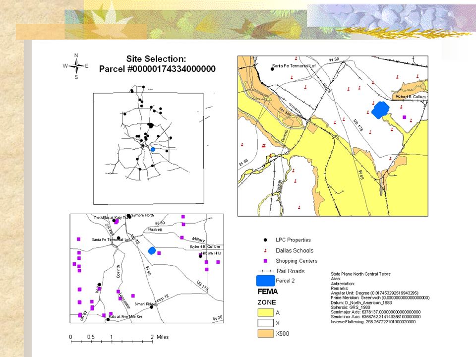
Results Parcel #00000174334000000 Zoned: MF2 2,048,354 Sq. feet ½- mile proximity Freeways/Rail/Schools/Shops Flood Plain: X

16
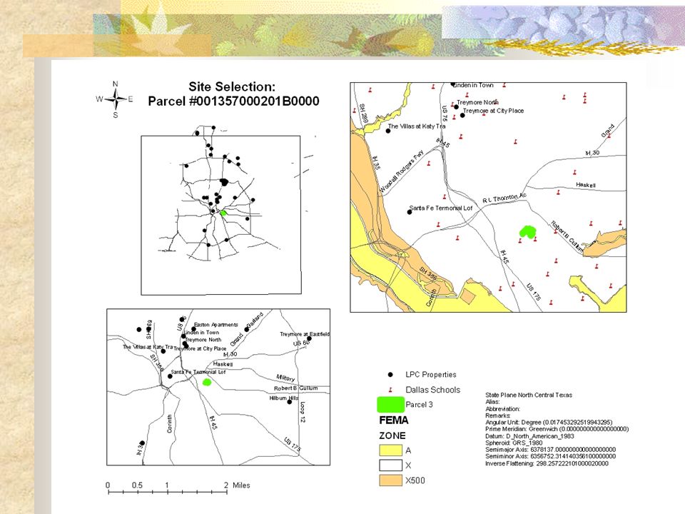
Results continued… Parcel # 001357000201B0000 Zoned: MF2 378,059 Sq. feet ½-mile proximity to Freeways/Schools Flood Plain: X

18
Future Research For the property management industry, the project’s concept is positive, and it is a good start. Though, proximity is not the only thing that is evaluated. Demographics is another important aspect for site selection for LPC. Finding a way to analyze area demographics and proximity to spatial features would be beneficial for this company and to the industry itself. LPC has a property size standard of 283,000 sq.feet, which could be one parcel or a combination of many parcels. Finding a way of incorporating more than one parcel in this spatial model could be quite useful. Find a faster yet more efficient way of dealing with large datasets such as the DCAD with the Dallas County parcel shapefile. Much time was wasted due to slow processing of the large datasets.

19
References Webb, S. (2003). Oversupply Hinders Multifamily Recovery [Electronic version]. National Real Estate Investor. Retrieved May 27, 2004, from http://nreionline.com/microsites Author Unknown (1996). New apartment report makes strong case for renting [Electronic version]. National Real Estate Investor. Retrieved May 27, 2004, from http://nreionline.com/microsites Church, R (2001). Computer & Operations Research: Geographical information systems and location science. Retrieved May 27, 2004 from the University of Texas at Dallas, McDermott Library: Web of Sciences. Nyerges, T., Montejano, R., Oshiro, C., Dadswell, M. (1998). Transportation Research Part C: Emerging Technologies: Group-based geographic information systems for transportation improvement site selection. Retrieved May 27, 2004 from the University of Texas at Dallas, McDermott Library: Web of Sciences. Vlachopoulou, M., Silleos, G., Manthou, V. (2001). International Journal of Production Economics: Geographic information systems in warehouse site selection decisions. Retrieved May 27, 2004 from the University of Texas at Dallas, McDermott Library: Web of Sciences. Overmyer, S. (n.d.). GIS in Business Education. Retrieved May 27, 2004, http://spatial.maine.edu/ucgis/testproc/overmyer.html http://spatial.maine.edu/ucgis/testproc/overmyer.html Francica, J. (2002). Frederick’s of Hollywood “uncovers” the secret to retail site selection [Electronic version]. Directions Magazine. Retrieved May 27, 2004, from http://www.directionsmag.com http://www.directionsmag.com
![References Webb, S. (2003). Oversupply Hinders Multifamily Recovery [Electronic version].](http://images.slideplayer.com/31/9615868/slides/slide_19.jpg "National Real Estate Investor. Retrieved May 27, 2004, from Author Unknown (1996). New apartment report makes strong case for renting [Electronic version]. National Real Estate Investor. Retrieved May 27, 2004, from Church, R (2001). Computer & Operations Research: Geographical information systems and location science. Retrieved May 27, 2004 from the University of Texas at Dallas, McDermott Library: Web of Sciences. Nyerges, T., Montejano, R., Oshiro, C., Dadswell, M. (1998). Transportation Research Part C: Emerging Technologies: Group-based geographic information systems for transportation improvement site selection. Retrieved May 27, 2004 from the University of Texas at Dallas, McDermott Library: Web of Sciences. Vlachopoulou, M., Silleos, G., Manthou, V. (2001). International Journal of Production Economics: Geographic information systems in warehouse site selection decisions. Retrieved May 27, 2004 from the University of Texas at Dallas, McDermott Library: Web of Sciences. Overmyer, S. (n.d.). GIS in Business Education. Retrieved May 27, 2004, Francica, J. (2002). Frederick’s of Hollywood uncovers the secret to retail site selection [Electronic version]. Directions Magazine. Retrieved May 27, 2004, from")
Similar presentations