Download presentation
Presentation is loading. Please wait.

1
INSPIRE Data validation: the eENVplus experience --- Extension of the INSPIRE DS: the GeoSmartCity experience NRC EIS meeting Copenhaghen Nov 26 th, 2015

2
Outline INSPIRE data Validation: The eENVplus experience The eENVplus Validation Service Focus on Protected Sites INSPIRE data usability beyond formal conformance INSPIRE Data Specification extension INSPIRE codelists extension

3
60 datasets 15 application schemas GML files WFS GetFeature requests Re-usable web service for validation of GML files …… More than 500 emails Skype calls on-line validation tool for INSPIRE and AQD datasets. INSPIRE DATA VALIDATION: the eENVplus experience

4
INSPIRE conformance and ATS concepts + automated validation + guidelines to manual validation + Schematron library currently available: PS (v3.0, v4.0), LC vector v4.0. Upcoming: NZ v4.0 The Validation Service

5
CDDA in conformity with INSPIRE the EAGLE project The eENVplus Validation Service and Land Cover theme-specific schematron have been used for the validation of the datasets produced in the project. Re-use of the eENVplus Validation Service The eENVplus Validation Service and Protected Sites theme-specific schematron file have been used within conformance testing process of GML datasets obtained from the transformation of CDDA European data sets in conformity with the INSPIRE PS. GeoSmartCity LIFE+IMAGINE The eENVplus Validation Service and LC theme-specific schematron have been used for the validation of the datasets. The NZ theme-specific schematron file is being developed. The eENVplus Validation Service has been used for the validation of the datasets produced in the project. Also for validation of dataset against INSPIRE extended schemas.

6
Few statistics The Validation Service : few statistics

7
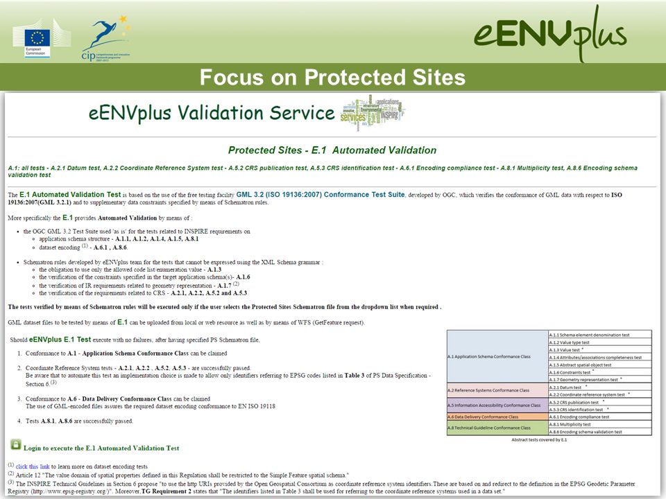
Focus on Protected Sites

9
Issues with : Coordinate Reference System identifiers: Implementation proposed by the Technical Guidelines (see A.8.2 CRS http URI test: ) require the use of EPSG identifiers in the form of http URIs. Currently some GIS software tools do not correctly handle EPSG identifiers, above all in the form of http URIs and therefore use the default (Lon Lat) order causing incorrect display of GML files in GIS maps Geometry representation: The specification allow 2.5-dimensional geometries, but when third coordinate is provided in the GML file, some GIS tools are not able to handle it and a set of triangles is displayed is the map. INSPIRE data usability: beyond a formal conformance
 order causing incorrect display of GML files in GIS maps Geometry representation: The specification allow 2.5-dimensional geometries, but when third coordinate is provided in the GML file, some GIS tools are not able to handle it and a set of triangles is displayed is the map. INSPIRE data usability: beyond a formal conformance.")
10
urn:ogc:def:crs:EPSG::4258http://www.opengis.net/def/crs/EPSG/0/4258 QGIS GAIA No Data displayed A practical example from EEA: the PS dataset “CDDA_INSPIRE_ITA.gml”

11
LCUnits: a matter of mapping Mapping of the ’member’ association A practical example for the LC datasets

12
Embedded encodingReferenced encoding QGIS GAIA A practical example for the LC datasets

13
Extended INSPIRE data models have been created in the frame of the GeoSmartCity EU funded project dealing with integrated management of underground utility infrastructures and renewable energy within cities. To match data modelling requirements collected in the pilots’ use cases, the INSPIRE core Buildings2D and Utility Networks schemas have been extended: 1.re-using some elements of the INSPIRE extended schemas contained in the draft repository 2.adding new elements (FeatureTypes, DataTypes, Codelists, Associations) INSPIRE Data Specification extensions UML models and XSDs available on the Thematic Cluster. More information about the development of the extended data model in the webinars available in the ‘INSPIRE_in_pills’ playlist on Epsilon Italia YouTube channel.
 INSPIRE Data Specification extensions UML models and XSDs available on the Thematic Cluster. More information about the development of the extended data model in the webinars available in the ‘INSPIRE_in_pills’ playlist on Epsilon Italia YouTube channel..")
14
14 Utility Networks ExtendedBuilding Extended INSPIRE Data Specification extensions

15
In order to manage new codelist values, a GeoSmartCity registry has been created using the Re3gistry software (http://hub.geosmartcity.eu/registry/).http://hub.geosmartcity.eu/registry/ Key question: TG Recommendation 5 : «The http URIs and labels used for encoding code list values should be taken from the INSPIRE code list registry for INSPIRE-governed code lists and generated according to the relevant rules specified for externally governed code lists.» Our thinking is that a registry providing an extended register or code list should include the items/values from the register that is being extended, but with their original URIs, and possibly links to their definition in the register that is being extended. This functionality is not yet supported out of the box by the Re3gistry software (currently we are manually changing URI to address INSPIRE registry when needed) INSPIRE codelist extensions
 INSPIRE codelist extensions.")
16
In the meanwhile we created an online Google Drive spreadsheet to be filled by the pilots with their new codelist values. The spreadsheet follows a data structure that will allow direct upload in the Re3gistry. In this spreadsheet, for each new codelist value one row specifying the value in English must be inserted (mandatory) multiple rows containing the codelist value in national languages can be inserted optionally (one row for each language). INSPIRE codelist extensions
 multiple rows containing the codelist value in national languages can be inserted optionally (one row for each language). INSPIRE codelist extensions.")
17
Authors: Stefania Morrone, Giacomo Martirano, Fabio Vinci (Epsilon Italia)Epsilon Italia s.morrone@epsilon-italia.it g.martirano@epsilon-italia.it f.vinci@epsilon-italia.it Thank you
Epsilon Italia Thank you")
Similar presentations