Download presentation
Presentation is loading. Please wait.

2
Photo by Theresa Hardy

3
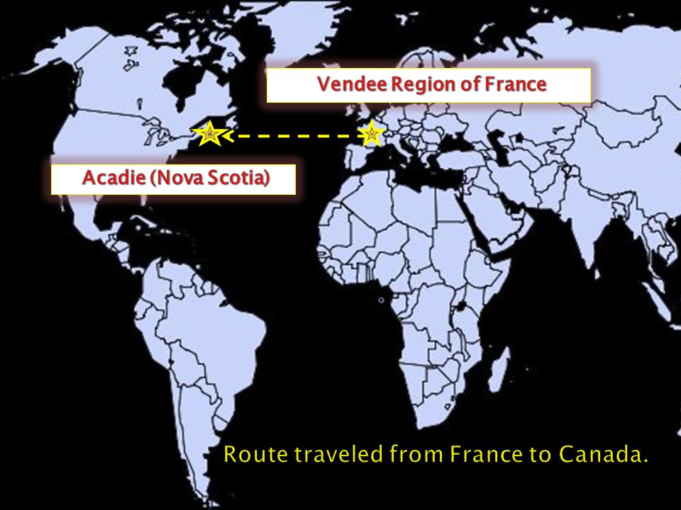
Vendee (France Map) Wikipedia Nova Scotia Map (Wikipedia
 Wikipedia Nova Scotia Map (Wikipedia")
5
About sixty French families were established in this area during the seventeenth century. The group learned about hunting and fishing techniques from the Aboriginal Mi'kmaq. (First Nations or Native American people who lived around Canada's Atlantic Provinces,)Mi'kmaqFirst NationsNative AmericanCanadaAtlantic Provinces For the most part, the Acadians lived mainly in the coastal regions. Farming and fishing were important to the Acadians. Acadians often found themselves on the front lines in conflict between French and British powers.
Mi kmaqFirst NationsNative AmericanCanadaAtlantic Provinces For the most part, the Acadians lived mainly in the coastal regions. Farming and fishing were important to the Acadians. Acadians often found themselves on the front lines in conflict between French and British powers..")
6
Wikipedia Photo

7
Wikipedia (Evangeline Statue)
")
10
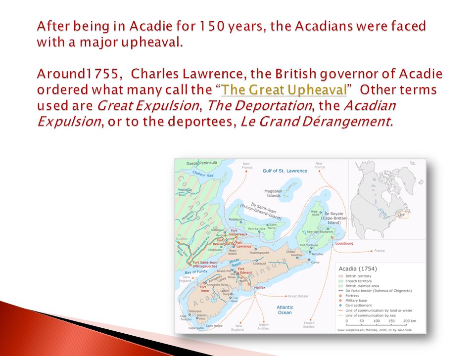
Acadian families were separated and shipped to various destinations including seven British American colonies: Connecticut New York Pennsylvania Maryland Massachusetts South Carolina Georgia Some were sent to French Caribbean (Antilles, Martinique, St. Domingue), while others to France. Map from Wikipedia
, while others to France. Map from Wikipedia.")
11
Connecticut 667 Connecticut New York 249 New York Maryland 810 Maryland Pennsylvania 383 Pennsylvania North Carolina 280 North Carolina Georgia 185 Georgia Massachusetts 1,043 Massachusetts St. John River (Maine & New Brunswick) 86 St. John RiverMaineNew Brunswick Île Saint-Jean (Prince Edward Island) 300 Île Saint-JeanPrince Edward Island Baie des Chaleurs (Québec & New Brunswick) 700 Baie des ChaleursQuébecNew Brunswick Nova Scotia 1,249 Nova Scotia Québec 2,000 Québec Louisiana 300 Louisiana England 866 England France 3,500 TOTAL 12,617 France Table source: R.A. LEBLANC. Les migrations acadiennes, in Cahiers de géographie du Québec, vol. 23, no 58, April 1979, p. 99-124. Wikipedia Photo Orders can be found in Wikipedia under "The Great Upheaval.“
 86 St. John RiverMaineNew Brunswick Île Saint-Jean (Prince Edward Island) 300 Île Saint-JeanPrince Edward Island Baie des Chaleurs (Québec & New Brunswick) 700 Baie des ChaleursQuébecNew Brunswick Nova Scotia 1,249 Nova Scotia Québec 2,000 Québec Louisiana 300 Louisiana England 866 England France 3,500 TOTAL 12,617 France Table source: R.A. LEBLANC. Les migrations acadiennes, in Cahiers de géographie du Québec, vol. 23, no 58, April 1979, p Wikipedia Photo Orders can be found in Wikipedia under The Great Upheaval. .")
15
St. John Parish St. James Parish Attakapas region (St. Martin Parish) St. Gabriel, Louisiana Vidalia (old location) Natchitoches (settlers relocated to Opelousas) Bayou Lafourche area
 St. Gabriel, Louisiana Vidalia (old location) Natchitoches (settlers relocated to Opelousas) Bayou Lafourche area.")
16
St. James Parish St. Martin Parish (Attakapas Region) St. John Parish Bayou Lafourche Natchitoches Natchitoches Relocated to Opelousas Opelousas Opelousas St. Landry Parish St. Gabriel Vidalia Vidalia (Concordia Parish) Early Acadian Settlement in Louisiana
 Early Acadian Settlement in Louisiana.")
18
Photo by Jude Dubois

20
Alexander Mouton Wikipedia Photo

21
Photo by Theresa Hardy

22
Alexandria Cameron Bayou Lafourche Acadian Triangle This map represents the area of Louisiana with the largest concentration of Acadian settlements and their living descendents. The area is often referred to as the Acadian Triangle.

24
Photo by Theresa Hardy

25
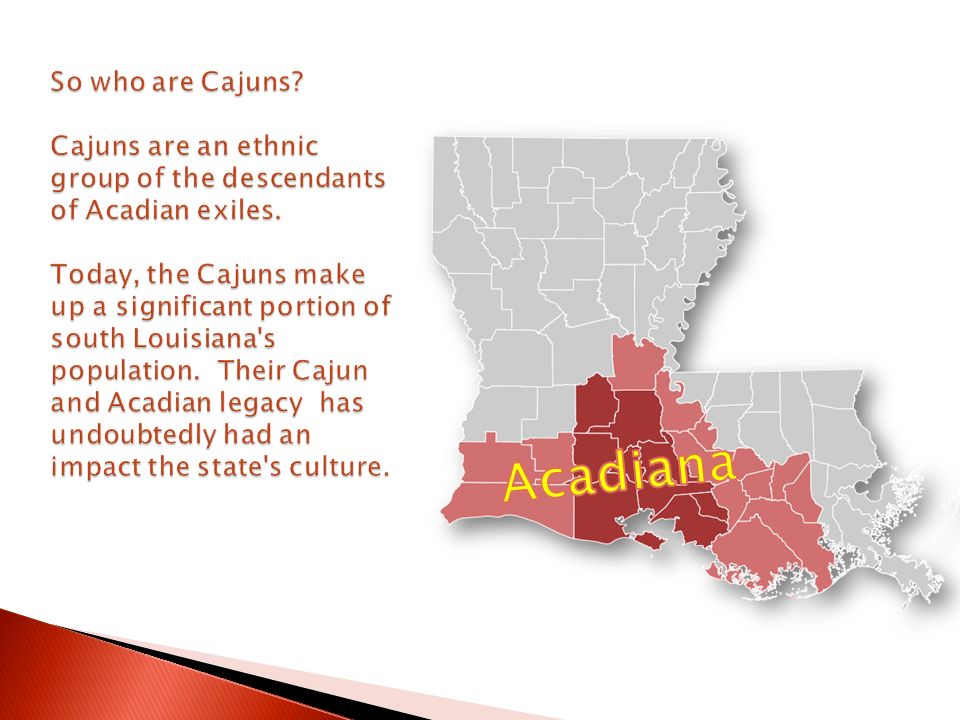
Acadiana Region in Louisiana (Wikipedia Map)
")
Similar presentations


.>")


 How will this affect Quebec? tensions rise Loyalists.>")


