Download presentation
Presentation is loading. Please wait.

1
The Scientific Foundation of the GEWEX Americas Prediction Program (GAPP) Dennis P. Lettenmaier Department of Civil and Environmental Engineering University of Washington CGU/AGU/SEG/EEGS Joint Assembly Montreal May 20, 2004

2
Continental-Scale Experiments (CSEs) “CATCH”>>AMMA GAPP MDB
 CATCH >>AMMA GAPP MDB")
3
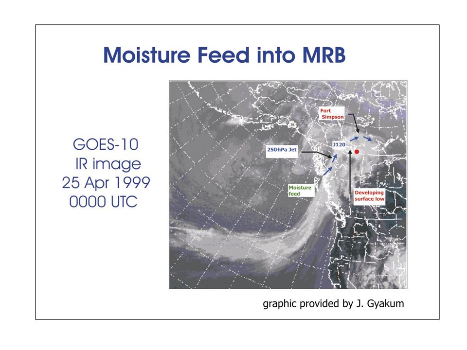
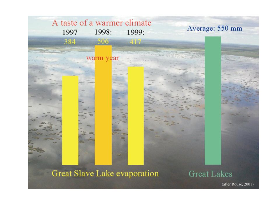
MAGS overall goals To understand and model the high-latitude energy and water cycles that play roles in the climate system To improve the ability to assess the changes to Canada’s water resources that arise from climate variability and anthropogenic climate change.

4
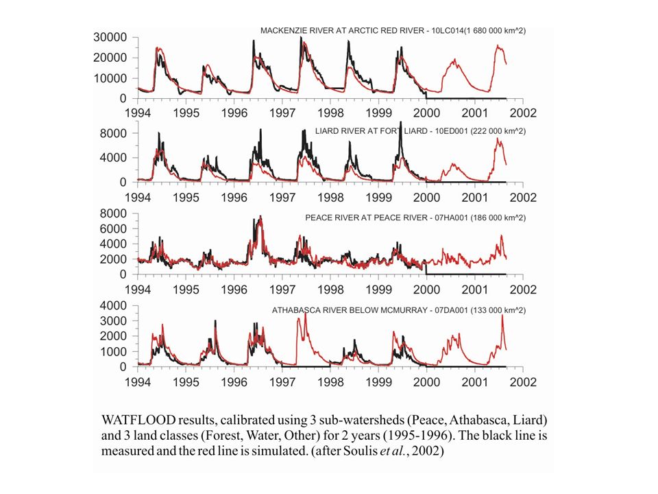
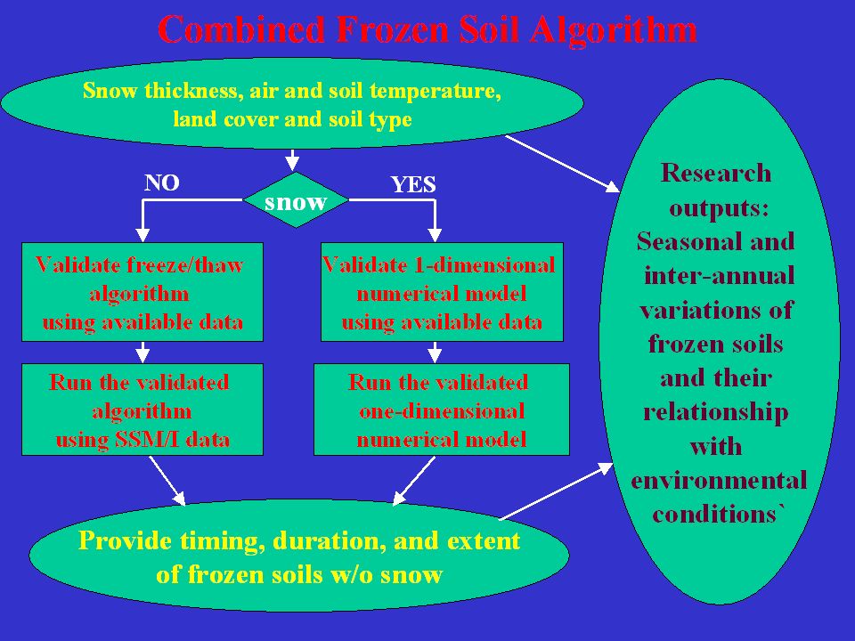
MAGS Focus Areas Atmospheric Research Large-scale Forcings and Interactions Regional Processes Upscale Influence Warm-season Processes Land Surface Processes Snow Processes Surface Energy Balance Lake Processes Large Lake Characteristics and Behaviour Hydrologic Processes Flow Production Flow Routing Flow Integration Flow Prediction Coupled Modelling The Canadian Regional Climate Model (CRCM) The Mesoscale Compressible Community (MC2) Model WATCLASS Data and Information Support
 The Mesoscale Compressible Community (MC2) Model WATCLASS Data and Information Support")
5
MAGS priorities Process studies (storm generation, high latitude precipitation and snow, atmospheric and surface energy fluxes, lake dynamics, river ice breakup mechanisms, frost and moisture interactions) and associated algorithm development and improvement Enhancement of parameterization through enhanced spatial resolution, remote sensing and ground based quantification of parameters, scaled and optimized parameter aggregation Stand-alone testing of algorithms and parameter applications to land surface schemes such as CLASS and ISBA Linkages of models (e.g. MC2 with CLASS, radiation inputs to WATFLOOD) Continued updating of models by partner institutions (e.g. MC2, CLASS) Coupling of model feedback mechanisms (e.g. CRCM, CLASS and WATFLOOD) as part of the effort to create a fully coupled model for energy and water flux investigations at various scales.
 Continued updating of models by partner institutions (e.g. MC2, CLASS) Coupling of model feedback mechanisms (e.g. CRCM, CLASS and WATFLOOD) as part of the effort to create a fully coupled model for energy and water flux investigations at various scales..")
9
Demonstration Projects (selected) Hydroelectricity – application of MAGS models to improve streamflow forecasts for NWT Power Corporation; River Engineering – developing river ice breakup and flood forecasting tools for the Town of Hay River; Great Bear Lake – determining changes in ice cover of lake. Potential for significant publicity and outreach activities with community involvement

10
GAPP Overall Objectives To develop and demonstrate a capability to make reliable monthly to seasonal predictions of precipitation and land-surface hydrologic variables through improved understanding and representation of land surface and related hydrometeorological and boundary layer processes in climate prediction models interpret and transfer the results of improved seasonal predictions for the optimal management of water resources.

11
GAPP Priority Areas Predictability in Land Surface Processes Hydrometeorology of Orographic Systems Predictability in Monsoonal Systems Integration of Predictability Into Prediction Systems Testing of Models in Special Climate Regimes CEOP: Data and Studies for Model Development Use of Predictions for Water Resource Management

13
Activities/Research: Diagnostic Studies composites (positive-negative) on LLJ indices using observations and results of 10-year RSM runs (Mo) GCLLJGPLLJ Inverse relationship between rainfalls over the Great Plains and the southwest is due to inverse relationship between GCLLJ and GPLLJ
 on LLJ indices using observations and results of 10-year RSM runs (Mo) GCLLJGPLLJ Inverse relationship between rainfalls over the Great Plains and the southwest is due to inverse relationship between GCLLJ and GPLLJ")
14
NCEP-MRF9GSFC-NSIPPCCM 3.2 Correlations between GCM simulations and observations for JJA 65-97 GCMs with prescribed SST show some descriptive/predictive capability at least in the core monsoon region, indicating the potential predictability given SST In general, state_of_the art GCMs can’t simulate warm season precipitation well. Activities/Research: GCM Studies

15
- soil moisture signal dominant; - snow signal dominant in W in summer - climate signal strong in SE in winter Most of hydrological predictability comes from initial boundary conditions => importance of LDAS (Maurer) Hydrologic Predictability
 Hydrologic Predictability")
16
TRANSFERABILITY: LEARNING AND SHARING THROUGH MODEL APPLICATIONS IN OTHER REGIONS The Eta model with the same Parameters is being run in the Mississippi and la Platin Basins (H. Berbery) Issues to be assessed: Effects of Pantanal on land surface parameterizations. Assess model ability in an area of low data availability.
 Issues to be assessed: Effects of Pantanal on land surface parameterizations. Assess model ability in an area of low data availability..")
17
1. Downscaling 2. VIC hydrologic simulations University of Washington experimental west-wide hydrologic prediction system ESP as baseline fcst Real-time Ensemble Forecasts Ensemble Hindcasts (for bias-correction and preliminary skill assessment) West-wide forecast products streamflow soil moisture, snowpack tailored to application sectors fire, power, recreation * ESP extended streamflow prediction (unconditional climate forecasts run from current hydrologic state) climate model output (NCEP,NSIPP) CPC official forecasts
 West-wide forecast products streamflow soil moisture, snowpack tailored to application sectors fire, power, recreation * ESP extended streamflow prediction (unconditional climate forecasts run from current hydrologic state) climate model output (NCEP,NSIPP) CPC official forecasts.")
18
Land Data Assimilation System (LDAS) “LDAS” concept: - Optimal integration of land surface observations and models to operationally obtain high quality land surface conditions and fluxes. -Continuous in time&space; multiple scales; retrospective, realtime, and forecast

19
Conduct a pilot 3.5 (2.5? 2?) year synoptic climatological case study of regional and global water and energy budgets as a guide to the interpretation of longer- term past and future global and regional analyses and observations. 4DDA MPIM GLDAS Goddard In Situ UCAR Remote Sensing/Data Integration U. Tokyo User 500 TB0.1 TB50 TB100 TB? CEOP WESP (Water & Energy Simulation and Prediction) (AFTER JOHN ROADS)
 year synoptic climatological case study of regional and global water and energy budgets as a guide to the interpretation of longer- term past and future global and regional analyses and observations. 4DDA MPIM GLDAS Goddard In Situ UCAR Remote Sensing/Data Integration U. Tokyo User 500 TB0.1 TB50 TB100 TB. CEOP WESP (Water & Energy Simulation and Prediction) (AFTER JOHN ROADS).")
20
REGIONAL REANALYSIS Regional Reanalysis will be run in real time at NCEP/CPC Two key advancements in RR over the Global Reanalysis 1)Assimilation of observed precipitation 2)Improved land surface model (Noah LSM) High resolution, dynamically consistent historical NA analysis NCEP/ETA MODEL 32 KM Spatial Resolution; 3 Hourly Temporal Resolution; 1979 through 2003 (REGIONAL REANALYSIS DOMAIN)
Assimilation of observed precipitation 2)Improved land surface model (Noah LSM) High resolution, dynamically consistent historical NA analysis NCEP/ETA MODEL 32 KM Spatial Resolution; 3 Hourly Temporal Resolution; 1979 through 2003 (REGIONAL REANALYSIS DOMAIN)")
21
Some key differences GAPP vs MAGS GAPP – much larger program (~$US 5-6M/yr, vs ~US 1- 2 for MAGS) MAGS – selected science team (in MAGS-2) based on targeted proposal, rather than annual solicitation and selection MAGS – stronger focus on land surface hydrology MAGS – field campaign (CAGES), GAPP no field campaign (although NAME is partially a GAPP activity) GAPP – core project assures connection with operating agencies (NCEP in particular) – MAGS has no such formal connection (especially MAGS-2) MAGS – formal “community model” (for land – WATCLASS) – no such for GAPP (although NCEP NOAH model has been used by part of the GAPP community) GAPP – more focus on water resources applications (although still a weak link) MAGS – IAP offers annual assessments; GAPP has more formal advisory panel, but less frequent advice
 MAGS – selected science team (in MAGS-2) based on targeted proposal, rather than annual solicitation and selection MAGS – stronger focus on land surface hydrology MAGS – field campaign (CAGES), GAPP no field campaign (although NAME is partially a GAPP activity) GAPP – core project assures connection with operating agencies (NCEP in particular) – MAGS has no such formal connection (especially MAGS-2) MAGS – formal community model (for land – WATCLASS) – no such for GAPP (although NCEP NOAH model has been used by part of the GAPP community) GAPP – more focus on water resources applications (although still a weak link) MAGS – IAP offers annual assessments; GAPP has more formal advisory panel, but less frequent advice")
22
Conclusions Need for focus Role of field campaigns Role of the CSEs in GEWEX (Global Energy and Water)
")
Similar presentations


 Outline : - CPPA background - major past and ongoing activities and achievements - opportunities/advances.>")

 Ben Kirtman (Co-Chair WGSIP) George Mason University Center for Ocean-Land-Atmosphere.>")

