Download presentation
Presentation is loading. Please wait.

1
Nutrient and Sediment Loading in Sougahatchee Creek and the Impacts on Aquatic Biota Report submitted to West Point Stevens and the Cities of Auburn and Opelika, Alabama

2
Acknowledgments: Funding for this project was provided by: the City of Auburn, Alabama the City of Auburn, Alabama the City of Opelika, Alabama the City of Opelika, Alabama West Point Stevens West Point Stevens

3
WHY STUDY SOUGAHATCHEE CREEK?

5
SougahatcheeCreek YatesLake Photo taken on April 13, 1999

6
Project Objectives: 1.Measure concentrations and estimate annual loading of plant nutrients, total suspended solids (sediments) and metals 2.Examine physical habitat conditions of the streams and conduct bioassessments utilizing benthic macroinvertebrate communities 3.Using GIS technology, examine and quantify land cover for the entire Sougahatchee Basin from 1993 and 2001 satellite imagery and aerial photography 4.Using regression analysis, examine relationships between basin land cover, nutrient and sediment loading and biological condition of the streams
 and metals 2.Examine physical habitat conditions of the streams and conduct bioassessments utilizing benthic macroinvertebrate communities 3.Using GIS technology, examine and quantify land cover for the entire Sougahatchee Basin from 1993 and 2001 satellite imagery and aerial photography 4.Using regression analysis, examine relationships between basin land cover, nutrient and sediment loading and biological condition of the streams")
7
WHAT ARE PLANT NUTRIENTS ? Nitrogen (NO 2, NO 3, NH 3, TN) Nitrogen (NO 2, NO 3, NH 3, TN) Phosphorus (SRP or PO 4, TP) Phosphorus (SRP or PO 4, TP) Potassium (K) Potassium (K)
 Nitrogen (NO 2, NO 3, NH 3, TN) Phosphorus (SRP or PO 4, TP) Phosphorus (SRP or PO 4, TP) Potassium (K) Potassium (K).")
8
NO 3 PO 4 NH 3 K

9
* EPA recommends 0.05 mg/L as the maximum concentration of total phosphorus for flowing streams entering a lake. ** 0.1 mg/L = 1 ounce in 80,000 gallons of water ** *

10
Dam Forebay Sougahatchee Embayment EFFECT OF NUTRIENTS

11
Figure 1 – Sougahatchee Creek at Pratt property looking upstream from mid-channel. On Wednesday, July 19, 2000, personnel from the Montgomery Branch of the Field Operations Division investigated a pollution complaint reported on the Sougahatchee Creek approximately ½ mile upstream of the Alabama State highway 49 bridge crossing in Tallapoosa County. EUGLENOID ALGAL BLOOM IN CREEK Sougahatchee Creek

12
Sampling Locations within the Sougahatchee Creek Basin

13
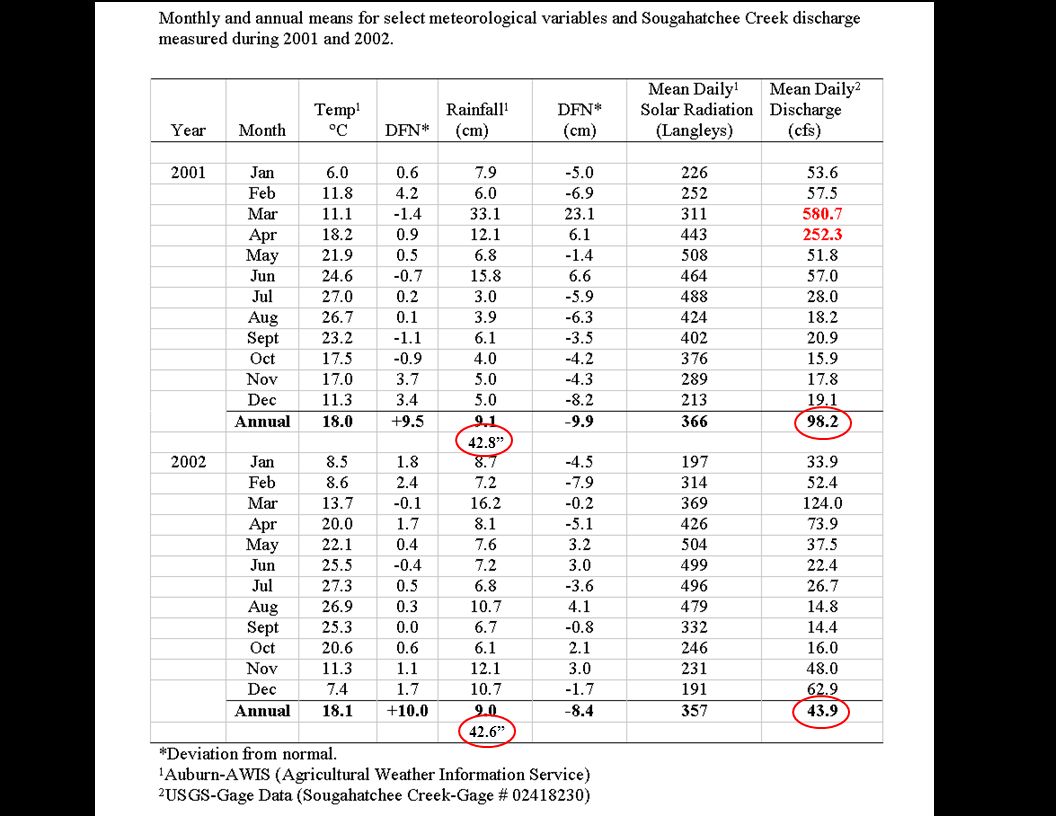
42.8” 42.6”
14
2001 Month 2002

15
Measuring Stream Discharge Measuring Stream Discharge *

Similar presentations


