Download presentation
Presentation is loading. Please wait.

1
Brian Haggard Arkansas Water Resources Center UA Division of Agriculture Arkansas Water Resources Center

2
To support modeling efforts in basins with little water quality information. 1. Monitoring sites with USGS gages to estimate nutrient and sediment loads. 2. Monitoring HUC-12 outlets to better understand how water quality changes across sub-watersheds draining different land uses UA Division of Agriculture Arkansas Water Resources Center

3
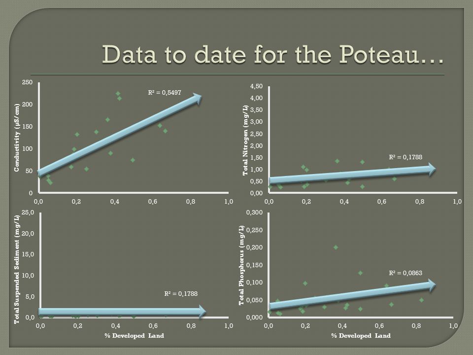
Poteau Watershed (HUC 11110105) USGS 07247000 USGS 07249400
 USGS USGS")
4
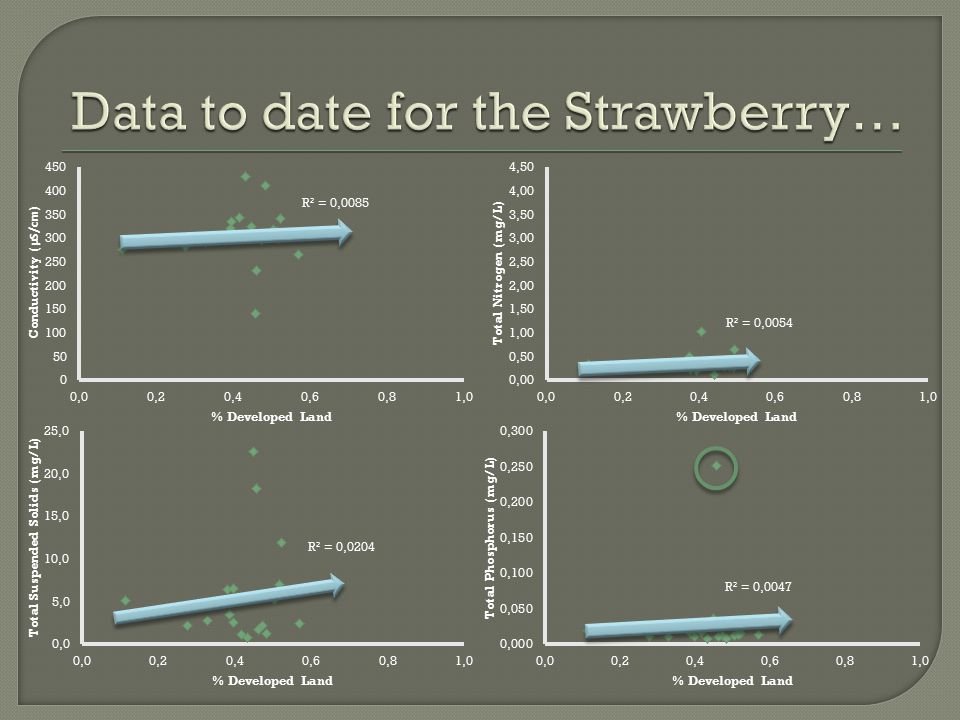
UA Division of Agriculture Arkansas Water Resources Center Strawberry Watershed (HUC 11010012) USGS 07074000
 USGS")
5
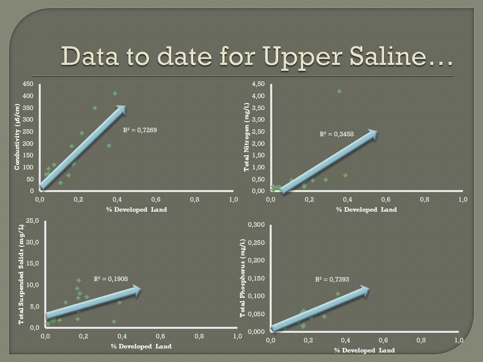
UA Division of Agriculture Arkansas Water Resources Center Upper Saline Watershed (HUC 0804203) USGS 07362587 USGS 07363000 USGS 07363200 USGS 07363400
 USGS USGS USGS USGS")
6
Water samples were collected once a month during base flow conditions. Samples were collected from a single vertical point in the stream Rising, peak and falling flows were targeted during each storm events.

7
Stage recorded in 30 minute intervals by USGS to estimate discharge. Water samples were analyzed at the AWRC WQL for: Soluble Reactive P Total P Nitrate-N Total N Total Suspended Solids Conductivity Turbidity

8
Linear regression will be used to determine the relationship between daily load and daily flow: ln(L d ) = β o + β 1 ln(Q d ) —or— ln(L d ) = β o + β 1 ln(Q d ) + β 2 sin(2πT) + β 3 cos(2πT) BCF will be used to remove bias from log transformations:
 = β o + β 1 ln(Q d ) —or— ln(L d ) = β o + β 1 ln(Q d ) + β 2 sin(2πT) + β 3 cos(2πT) BCF will be used to remove bias from log transformations:")
9
UA Division of Agriculture Arkansas Water Resources Center Sampling began in October 2011. Monthly base flow and several storm events were collected through project year (June 2012). USGS 07247000 USGS 07249400 9 Base flow & 11 Storm event
. USGS USGS Base flow & 11 Storm event.")
10
UA Division of Agriculture Arkansas Water Resources Center USGS 07074000 Sampling began in October 2011. Monthly base flow and several storm events were collected through project year (June 2012). 9 Base flow & 9 Storm event
. 9 Base flow & 9 Storm event.")
11
UA Division of Agriculture Arkansas Water Resources Center USGS 07362587 USGS 07363000 USGS 07363200 USGS 07363400 Sampling began in October 2011. Monthly base flow and several storm events were collected through project year (June 2012). 9 Base flow & 5 Storm event 9 Base flow & 8 Storm event 9 Base flow & 7 Storm event
. 9 Base flow & 5 Storm event 9 Base flow & 8 Storm event 9 Base flow & 7 Storm event.")
12
UA Division of Agriculture Arkansas Water Resources Center Sampling Limitations: Less rainfall in 2012. Proximity of locations. We’ve missed a few storms because we didn’t know it was going to rain in other parts of the state!

13
UA Division of Agriculture Arkansas Water Resources Center Low High LAND USE %Pasture and Urban Phosphorus Concentration Low High LAND USE % Forest Phosphorus Concentration Low High We can use HUC 12 data to compare measured concentrations to land use.

14
UA Division of Agriculture Arkansas Water Resources Center Specific HUCs where management actions can be focused. Upper Illinois River Watershed

15
UA Division of Agriculture Arkansas Water Resources Center MonitoringModeling

16
UA Division of Agriculture Arkansas Water Resources Center

20
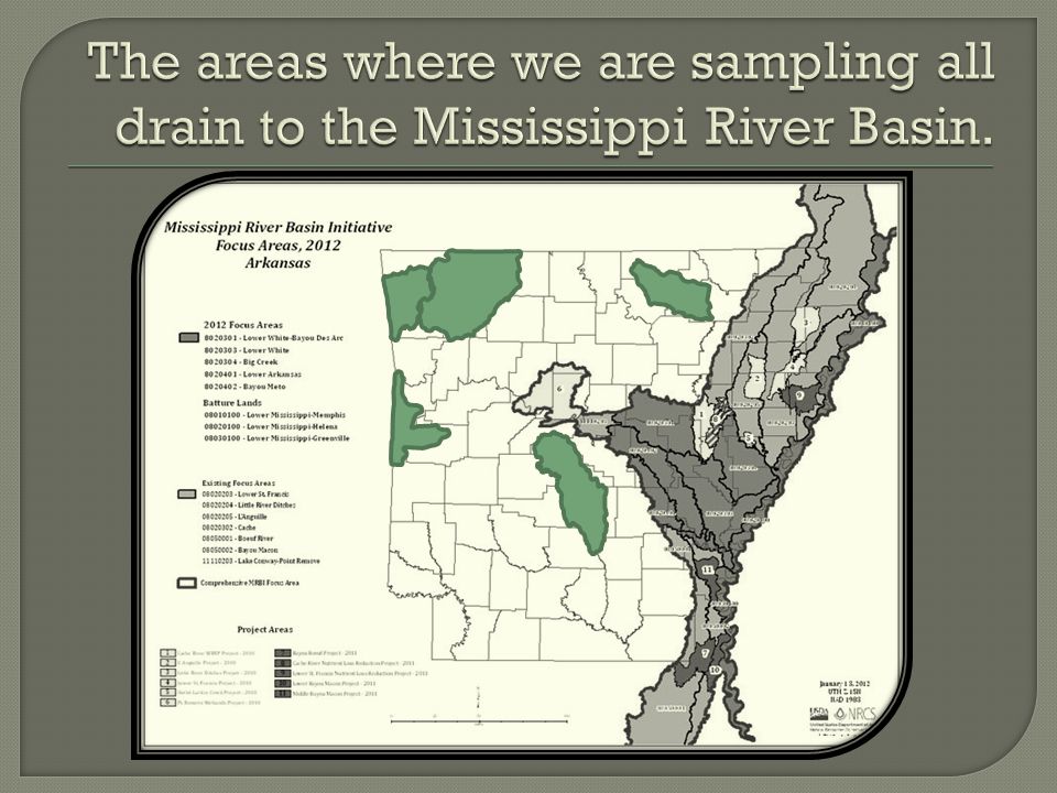
“To improve the health of the Mississippi River Basin, including water quality and wildlife habitat, the USDA and its partners will help producers in selected watersheds in the Mississippi River Basin voluntarily implement conservation practices and systems that avoid, control, and trap nutrient runoff; improve wildlife habitat; and maintain agricultural productivity.”

23
UA Division of Agriculture Arkansas Water Resources Center

Similar presentations


 Urbanization ERS 482/682 Small Watershed Hydrology.>")


