Download presentation
Presentation is loading. Please wait.

1
Global Ocean Circulation (2) 1.Wind-driven gyre-scale circulation of the surface ocean and upper thermocline 2.Global heat and freshwater water transport, conservation properties 3.Water mass properties, polar convection and mixing, tracers, global thermohaline circulation Focus on conservation principles: Balancing heat, salt, etc. into and out of boxes © Donglai Gong

4
Sea surface topography variations PhenomenonTypical Surface Expression Period of Variability Comments Western boundary currents (Gulf Stream, Kuroshio) 130 cm/100 kmDays to yearsVariability in position, and 25% variability in transport Large gyres50 cm/ 3000 kmOne to many years 25% variability expected Eastern boundary currents 30 cm/100 kmDays to years100% variability expected, possible direction reversals Mesoscale eddies25 cm/100 km100 days100% variability Rings100 cm/100 kmWeeks to years100% variability, growth and decay Equatorial currents30 cm/5000 kmMonths to years100% variability Tides100cm/5000 kmHours to yearsAliased to low frequency http://jeffreyearly.com/science /qg-eddies-paper/
 130 cm/100 kmDays to yearsVariability in position, and 25% variability in transport Large gyres50 cm/ 3000 kmOne to many years 25% variability expected Eastern boundary currents 30 cm/100 kmDays to years100% variability expected, possible direction reversals Mesoscale eddies25 cm/100 km100 days100% variability Rings100 cm/100 kmWeeks to years100% variability, growth and decay Equatorial currents30 cm/5000 kmMonths to years100% variability Tides100cm/5000 kmHours to yearsAliased to low frequency /qg-eddies-paper/")
6
+=

7
http://ferret.pmel.noaa.gov/nvods/UI.vm#panelHeaderHidden=false;differences=false; autoContour=false;globalMin=2.566;globalMax=29.03;xCATID=WOA_05_CAT;xDSID =woa05_monthly;varid=t0112an1;imageSize=auto;over=xy;compute=Nonetoken;tlo=1 6-Jan-0001;thi=16-Jan- 0001;catid=WOA_05_CAT;dsid=woa05_monthly;varid=t0112an1;avarcount=0;ylo=21; yhi=21;xlo=110;xhi=260;ylo=21;yhi=21;zlo=0;zhi=1500;operation_id=Plot_2D_zoom;vi ew=xz

8
Everywhere between the maximum of the westerlies, and the maximum of the Trades, there is convergence of Ekman transport

9
wind

10
westerlies easterlies max. of westerlies max. easterlies zone of Ekman convergence

12
http://ferret.pmel.noaa.gov/nvods

13
wind

15
Positive implies ocean warming Warming everywhere – of course

16
Positive implies ocean warming Negative implies ocean cooling Net longwave is less in WPWP than in east yet water is warmer?

17
Positive implies ocean cooling Western boundary currents have greatest air-sea temperature difference

18
COADS monthly climatology http://ferret.pmel.noaa.gov/NVODS/servlets/dataset?catitem=18098http://ferret.pmel.noaa.gov/NVODS/servlets/dataset?catitem=18098 Positive implies ocean coolingDistribution largely follows SST

19
Shaded is net cooling

20
Western boundary currents are all cooling Equator is warming – especially in the east

21
Shaded is net cooling

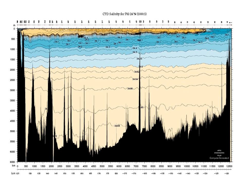
24
RT = Radiation total at the top of the atmosphere from Earth Radiation Budget Experiment OT = ocean transport from net air-sea heat flux AT = atmospheric transport (calculated from RT – OT)
")
25
E-P-R = 4.6 x 10 4 m 3 /s ? Write equations for conservation of (1) salt (2) volume Mean flow through the Strait of Gibralter is: >> in to the Mediterranean Sea at the surface, and << out of the Med Sea at depth
 salt (2) volume Mean flow through the Strait of Gibralter is: >> in to the Mediterranean Sea at the surface, and << out of the Med Sea at depth.")
26
E-P-R = 4.6 x 10 4 m 3 /s

27
4.6 x 10 4 / (38.3/36.2 -1) = 0.79 x 10 6 m 3 /s
 = 0.79 x 10 6 m 3 /s")
28
http://ferret.pmel.noaa.gov/NVODS/servlets/dataset?catitem=5707

32
Bars show direct estimates from oceanographic cross-sections

33
Heat transport from ocean observations constrained by conservation principles Atlantic has northward heat transport everywhere

35
Atlantic heat transport is so different because there is a vertical over-turning circulation that shows up clearly in patterns of salinity

36
SouthNorth Low salinity in north but no large negative E-P. What other freshwater sources are there? Where evaporation is strong we tend to have high salinity

37
Precipitation minus evaporation (m year -1 ) Shaded implies net precipitation Earth’s water budget is dominated by P-E over the ocean (80% occurs there) Max P-E in East Pacific is not exactly over the equator – why?
 Shaded implies net precipitation Earth’s water budget is dominated by P-E over the ocean (80% occurs there) Max P-E in East Pacific is not exactly over the equator – why")
38
Surface Atlantic is saltier than the Pacific Many large rivers drain into the Atlantic and the Arctic Sea, so why is the Atlantic saltier than the Pacific?

39
Broecker (1997) showed that 0.32 Sv of the water evaporated from the Atlantic does not fall as rain on land. It is carried by winds into the Pacific. The quantity is small, equivalent to little more than the flow in the Amazon River. But were this flux not compensated by an exchange of more salty Atlantic waters for less salty Pacific waters, the salinity of the Atlantic would rise about 1 gram per liter per millennium.

Similar presentations


 Paulo Nobre (INPE) São Paulo Summer School on Global Climate Modeling October,>")


 Convection caused by intense surface.>")


 Winds and wind-driven basin circulation Meanders, rings, eddies and gyres The thermohaline circulation.>")
 H Jet Stream Jet Stream L Warm KOE>")


