Download presentation
Presentation is loading. Please wait.

1
Today’s Lecture Field Geophysics

2
Announcements Lecture today: field geophysics Thursday: guest lecture (Alice Conovitz, Integral) Lab Lab 1: Phase I ESA re-write grading in progress Lab 3: Soil sampling grading in progress Lab 4: Well drilling grading in progress Lab 5: Slug tests lab report due Wed Nov 11
 Lab Lab 1: Phase I ESA re-write grading in progress Lab 3: Soil sampling grading in progress Lab 4: Well drilling grading in progress Lab 5: Slug tests lab report due Wed Nov 11")
3
Announcements Lab Lab 6 – geophysics; resistivity and GPR tentative Sampling and Analysis Plan (SAP) description of sites SAP resources (submission) SAP outline (submission) SAP report (submission)
 description of sites SAP resources (submission) SAP outline (submission) SAP report (submission)")
4
Sampling and Analysis Plan Site 1: Boulder Town Gas Plant The City of Boulder purchased the property in 1975 and became aware of subsurface contamination in 2004. The City decided to address the contamination with a voluntary cleanup. The site was characterized in 2011-2012 and the voluntary cleanup plan (VCUP) was submitted in October 2013. Prepare a sampling and analysis plan for the site characterization that was conducted before submission of the VCUP.
 was submitted in October Prepare a sampling and analysis plan for the site characterization that was conducted before submission of the VCUP..")
5
Sampling and Analysis Plan Site 2: Burlington Mine The Burlington Mine underwent a voluntary cleanup in 2003-2004 to prevent interaction between surface waters and waste rock, but acid mine drainage still discharges from a collapsed mine opening into Little James Creek. The EPA has considered the site for Superfund designation. Prepare a sampling and analysis plan to characterize the site in its current condition for risks relative to Superfund designation.

6
Sampling and Analysis Plan Site 3: Valmont Butte Mill The City of Boulder acquired the Valmont Butte property in 2000. Over the next few years, various uses were proposed, but concerns surfaced about the effect of contamination on these uses. A site investigation was conducted in 2009 to provide information for a voluntary cleanup plan (VCUP), which was submitted in 2010. Prepare a sampling and analysis plan for the site characterization conducted in 2009 to provide information for the VCUP.
, which was submitted in Prepare a sampling and analysis plan for the site characterization conducted in 2009 to provide information for the VCUP..")
7
Sampling and Analysis Plan Site 4: Captain Jack Mill The EPA added the site to the National Priorities List (the “Superfund list”) in 2003. The Remedial Investigation, Feasibility Study, and Proposed Plan were completed in 2008 and the remediation was mostly completed by 2012. The site is currently owned by a mixture of federal agencies, Boulder County, and private parties. Boulder County has an interest in purchasing the site to extend the Switzerland Trail and create a mountain bike park. Prepare a sampling and analysis plan to characterize the site for suitability for this proposed use.

8
Sampling and Analysis Plan Site 5: Boulder Cleaners Contamination was initially discovered at the site in 2000 and monitoring was continued over the next decade. In 2013, environmental consultants proposed to reduce contamination by injecting zero-valent iron into the groundwater. The reaction of compounds like PCE with iron should result in degradation by reductive dechlorination. Prepare a sampling and analysis plan to monitor the effectiveness of the zero-valent iron injection for reducing groundwater contamination.

9
Sampling and Analysis Plan Site 6: Centerline Circuits Disposal of chlorinated solvents to the plant’s septic system in the 1960s led to groundwater contamination that affected the drinking water supplies of over a dozen North Boulder residents in the late 1980s. The residents were eventually transferred to City of Boulder drinking water, but the groundwater contamination was never addressed. Prepare a sampling and analysis plan to assess the spread of the groundwater contamination in North Boulder for the design of a pump-and-treat remediation plan.

10
Field Geophysics Methods seismic – refraction, reflection gravity – density contrasts and anomalies geomagnetic – induced rock magnetism electromagnetic – ground-penetrating radar electrical – resistivity borehole – well-logging radiometric – radioactive decay and isotope dating geothermal – heat flow and conduction

11
Field Geophysics Methods seismic – refraction, reflection gravity – density contrasts and anomalies geomagnetic – induced rock magnetism electromagnetic – ground-penetrating radar electrical – resistivity borehole – well-logging radiometric – radioactive decay and isotope dating geothermal – heat flow and conduction

12
Field Geophysics Passive naturally-present sources and fields to create image of subsurface gravity field magnetic field earthquakes heat Active man-made sources to create image of subsurface hammer, dynamite, air guns, … electromagnetic waves electrical currents

13
Field Geophysics Choice of methods what relevant physical properties? porosity, permeability, seismic velocity, density, … what spatial scales? meters, tens of meters, hundreds of meters, kilometers, … what field conditions? e.g., urban, wetland, off-shore, … any useful prior information? e.g., previous geophysical surveys any cheaper alternatives? e.g., water level measurements

14
Field Geophysics Some references Burger H.R., Sheehan A.F., and Jones C.H., 2006. Introduction to Applied Geophysics: Exploring the Shallow Subsurface. W.W. Norton, 550 pp. Reynolds J.M., 2011. An Introduction to Applied and Environmental Geophysics, 2 nd Ed., Wiley, 710 pp.

15
Field Geophysics References Burger H.R., Sheehan A.F., and Jones C.H., 2006. Introduction to Applied Geophysics: Exploring the Shallow Subsurface. W.W. Norton, 550 pp. Reynolds J.M., 2011. An Introduction to Applied and Environmental Geophysics, 2 nd Ed., Wiley, 710 pp.

16
Field Geophysics

17
VMD (EM31): vertical magnetic dipole; electromagnetic ground conductivity HMD (EM31): horizontal magnetic dipole Magnetometer
: vertical magnetic dipole; electromagnetic ground conductivity HMD (EM31): horizontal magnetic dipole Magnetometer")
18
Field Geophysics

20
Applications forensic geophysics hydrocarbon exploration (coal, gas, oil) regional geologic studies (100s km 2 ) exploration for mineral deposits engineering site investigations hydrogeological investigations detection of subsurface cavities mapping of contaminant plumes location of buried metallic objects archaeogeophysics
 regional geologic studies (100s km 2 ) exploration for mineral deposits engineering site investigations hydrogeological investigations detection of subsurface cavities mapping of contaminant plumes location of buried metallic objects archaeogeophysics")
21
Field Geophysics Applications forensic geophysics hydrocarbon exploration (coal, gas, oil) regional geologic studies (100s km 2 ) exploration for mineral deposits engineering site investigations hydrogeological investigations detection of subsurface cavities mapping of contaminant plumes location of buried metallic objects archaeogeophysics
 regional geologic studies (100s km 2 ) exploration for mineral deposits engineering site investigations hydrogeological investigations detection of subsurface cavities mapping of contaminant plumes location of buried metallic objects archaeogeophysics")
22
Field Geophysics Applications forensic geophysics hydrocarbon exploration (coal, gas, oil) regional geologic studies (100s km 2 ) exploration for mineral deposits engineering site investigations hydrogeological investigations detection of subsurface cavities mapping of contaminant plumes location of buried metallic objects archaeogeophysics
 regional geologic studies (100s km 2 ) exploration for mineral deposits engineering site investigations hydrogeological investigations detection of subsurface cavities mapping of contaminant plumes location of buried metallic objects archaeogeophysics")
23
Field Geophysics Applications forensic geophysics hydrocarbon exploration (coal, gas, oil) regional geologic studies (100s km 2 ) exploration for mineral deposits engineering site investigations hydrogeological investigations detection of subsurface cavities mapping of contaminant plumes location of buried metallic objects archaeogeophysics
 regional geologic studies (100s km 2 ) exploration for mineral deposits engineering site investigations hydrogeological investigations detection of subsurface cavities mapping of contaminant plumes location of buried metallic objects archaeogeophysics")
24
Field Geophysics Interferences

25
Field Geophysics Influence of spatial sampling resolution

26
Field Geophysics Influence of spatial sampling resolution

27
Field Geophysics Influence of spatial sampling resolution

28
Field Geophysics Influence of spatial sampling resolution inverse problem often non-unique reinforce interpretation with multiple geophysical methods geologic knowledge

29
Field Geophysics Property contrasts electrical resistivity

30
Electrical Resistivity Electric current through ground survey of variations in electrical resistance Ohm’s Law resistivity (ohm m; m) apply known potential difference (V) to circuit through resistive material of known area and length
 apply known potential difference (V) to circuit through resistive material of known area and length")
31
Electrical Resistivity Electric current through ground circuit through multiple units (layers) series or parallel
 series or parallel")
32
Electrical Resistivity Resistivity of geologic materials metallic ores decrease resistivity temperature higher T with depth decreases resistivity water saturation higher water, lower resistivity higher salinity, lower resistivity anthropogenic features cavities increase resistivity

33
Electrical Resistivity Porous water-saturated rocks ionic conductors Archie’s Law (empirical) t resistivity (ohm m) a 0.5 – 2.5 w density porosity m 1.3 (Tertiary) – 2.0 (Paleozoic) for cementation s w water saturation n 2 if sw 0.3
 t resistivity (ohm m) a 0.5 – 2.5 w density porosity m 1.3 (Tertiary) – 2.0 (Paleozoic) for cementation s w water saturation n 2 if sw 0.3")
34
Electrical Resistivity Rock and mineral resistivity

35
Electrical Resistivity Subsurface current paths 70% of current within depth equal to electrode separation electrode spacing typically 2 target depth

36
Electrical Resistivity Typical setup number of electrodes: usually four applied voltage: about 100 V applied current: milliamps or less (shock possible) current flow reversed a few times per second
 current flow reversed a few times per second")
37
Electrical Resistivity Vertical electrical sounding identification of layers of different resistivity depth profiling by expansion of electrode spacing

38
Electrical Resistivity Vertical electrical sounding current refraction variation in resistivity with depth

39
Electrical Resistivity Current flow path geometry changes greater resistance measured over longer flow path apparent resistivity accounts for geometric factor = a/l for rod shape

40
Electrical Resistivity Wenner array of electrode spacing equal spacing between four electrodes apparent resistivity spacing increased progressively spacing increased until 2 desired depth modern systems include many electrodes to minimize re-arrange- ment time

41
Wenner survey results plotted as log a versus log a inverse problem master curves calculated for values of resistivity and layer thickness computer codes Electrical Resistivity shallower depths deeper depths

42
Wenner survey two layers, or more than two layers Electrical Resistivity

43
Lateral changes in resistivity Electrical Resistivity

44
Ground-Penetrating Radar GPR Radio Detection and Ranging (RADAR) initial interest in detecting ice depth (U.S. Air Force) first commercial systems 1974 high resolution (cm scale) contrast in electrical and magnetic properties detected with antenna
 first commercial systems 1974 high resolution (cm scale) contrast in electrical and magnetic properties detected with antenna.")
45
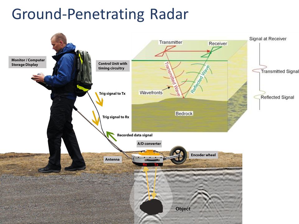
Ground-Penetrating Radar

47
GPR contrast for layers dielectric permittivity electrical conductivity must be greater than 50 ohm m for GPR magnetic permeability attenuation of radar wave

48
GPR Example of field application

49
Field Geophysics Seismic

50
Field Geophysics Seismic Material V p (m s -1 )
")
51
Field Geophysics Gravity

52
Field Geophysics Gravity density range average density material (Mg m -3 ) (Mg m -3 )
 (Mg m -3 )")
53
Field Geophysics Geomagnetics

54
Field Geophysics Geomagnetics magnetic mineral or rock susceptibility

55
Next Lecture guest lecture Thursday (Alice Conovitz, Integral) guest lecture Tuesday (Ned Turner, Indian Peaks)
 guest lecture Tuesday (Ned Turner, Indian Peaks)")
Similar presentations


>")


