Download presentation
Presentation is loading. Please wait.

1
Cypress Creek Project and the Desired Future Conditions Process Negotiating the Bumps at the Intersection of Science and Public Policy Douglas A. Wierman, P.G., Hays Trinity GCD October 1, 2009

2
Alphabet Soup GMA – Groundwater Management Area GMA – Groundwater Management Area GCD – Groundwater Conservation District GCD – Groundwater Conservation District DFC – Desired Future Condition DFC – Desired Future Condition MAG – Managed Available Groundwater MAG – Managed Available Groundwater GAM – Groundwater Availability Model GAM – Groundwater Availability Model TWDB – Texas Water Development Board TWDB – Texas Water Development Board DOR – Drought of Record DOR – Drought of Record

3
Outline of Today’s Presentation Overview of the DFC Process Overview of the DFC Process Hydrogeology of Jacob’s Well and Cypress Hydrogeology of Jacob’s Well and CypressCreek Status of GMA #9 DFCs and MAGs Status of GMA #9 DFCs and MAGs Possible DFC/MAG Implementation Strategies in HTGCD Possible DFC/MAG Implementation Strategies in HTGCD

4
Overview of the DFC Process In September, 2005, House Bill 1763 of the 79th Texas legislature became effective. HB 1763 was incorporated into Chapter 36 of the Texas Water Code. No funding made available. In September, 2005, House Bill 1763 of the 79th Texas legislature became effective. HB 1763 was incorporated into Chapter 36 of the Texas Water Code. No funding made available. Groundwater planning was regionalized into Groundwater Management Areas (GMAs) which consist of individual GCDs and areas not included in a GCD. Groundwater planning was regionalized into Groundwater Management Areas (GMAs) which consist of individual GCDs and areas not included in a GCD. With significant public input, GMAs must establish a Desired Future Conditions for each aquifer in the GMA for the period 2010 through 2060 by September 2010. With significant public input, GMAs must establish a Desired Future Conditions for each aquifer in the GMA for the period 2010 through 2060 by September 2010.
 which consist of individual GCDs and areas not included in a GCD. Groundwater planning was regionalized into Groundwater Management Areas (GMAs) which consist of individual GCDs and areas not included in a GCD. With significant public input, GMAs must establish a Desired Future Conditions for each aquifer in the GMA for the period 2010 through 2060 by September With significant public input, GMAs must establish a Desired Future Conditions for each aquifer in the GMA for the period 2010 through 2060 by September")
5
Overview of the DFC Process TWDB, primarily through the use of groundwater availability models, determines how much water can be pumped from the aquifer to achieve the DFC. This volume of water is known as the Managed Available Groundwater, or MAG. TWDB, primarily through the use of groundwater availability models, determines how much water can be pumped from the aquifer to achieve the DFC. This volume of water is known as the Managed Available Groundwater, or MAG. With public input, individual GCDs must develop management strategies and rules to permit groundwater withdrawal up to the MAG. With public input, individual GCDs must develop management strategies and rules to permit groundwater withdrawal up to the MAG.

6
Desired Future Conditions A quantitative description of a natural aquifer condition/property as a goal – not well discharges A quantitative description of a natural aquifer condition/property as a goal – not well discharges DFCs are set for all aquifers in a GMA DFCs are set for all aquifers in a GMA Aquifer may be subdivided “geographically” Aquifer may be subdivided “geographically” Approved by vote of two thirds of at least two- thirds of the GMA’s GCDs (In GMA #9, as few as 4 of 9 GCDs can determine DFCs for the entire GMA) Approved by vote of two thirds of at least two- thirds of the GMA’s GCDs (In GMA #9, as few as 4 of 9 GCDs can determine DFCs for the entire GMA)
 Approved by vote of two thirds of at least two- thirds of the GMA’s GCDs (In GMA #9, as few as 4 of 9 GCDs can determine DFCs for the entire GMA)")
7
Managed Available Groundwater Managed Available Groundwater – water that will be available to all end users that meets the DFC under applicable regulatory constraints Managed Available Groundwater – water that will be available to all end users that meets the DFC under applicable regulatory constraints MAG values are de facto “caps” and the mandatory basis for Regional/State Water Plans MAG values are de facto “caps” and the mandatory basis for Regional/State Water Plans Rules adopting/enforcing MAGs and supporting DFCs are mandatory upon all GCDs in a GMA Rules adopting/enforcing MAGs and supporting DFCs are mandatory upon all GCDs in a GMA

9
Major and Minor Aquifers of GMA #9 Edwards (BFZ) Edwards (BFZ) Edwards-Trinity (Plateau) Edwards-Trinity (Plateau) Trinity – Upper, Middle and Lower Trinity – Upper, Middle and Lower “Paleozoics” “Paleozoics” –Ellenburger-San Saba –Hickory –Marble Falls
 Edwards (BFZ) Edwards-Trinity (Plateau) Edwards-Trinity (Plateau) Trinity – Upper, Middle and Lower Trinity – Upper, Middle and Lower Paleozoics Paleozoics –Ellenburger-San Saba –Hickory –Marble Falls")
10
GCDs of GMA 9 Bandera County River Authority And Ground Water District Bandera County River Authority And Ground Water District Bandera County River Authority And Ground Water District Bandera County River Authority And Ground Water District Barton Springs/Edwards Aquifer Conservation District Barton Springs/Edwards Aquifer Conservation District Barton Springs/Edwards Aquifer Conservation District Barton Springs/Edwards Aquifer Conservation District Blanco-Pedernales Groundwater Conservation District Blanco-Pedernales Groundwater Conservation District Blanco-Pedernales Groundwater Conservation District Blanco-Pedernales Groundwater Conservation District Cow Creek Groundwater Conservation District Cow Creek Groundwater Conservation District Cow Creek Groundwater Conservation District Cow Creek Groundwater Conservation District Edwards Aquifer Authority Edwards Aquifer Authority Edwards Aquifer Authority Edwards Aquifer Authority Hays Trinity Groundwater Conservation District Hays Trinity Groundwater Conservation District Hays Trinity Groundwater Conservation District Hays Trinity Groundwater Conservation District Headwaters Groundwater Conservation District Headwaters Groundwater Conservation District Headwaters Groundwater Conservation District Headwaters Groundwater Conservation District Medina County Groundwater Conservation District Medina County Groundwater Conservation District Trinity-Glen Rose Groundwater Conservation District Trinity-Glen Rose Groundwater Conservation District Trinity-Glen Rose Groundwater Conservation District Trinity-Glen Rose Groundwater Conservation District No GCD in Comal or Travis Counties No GCD in Comal or Travis Counties

11
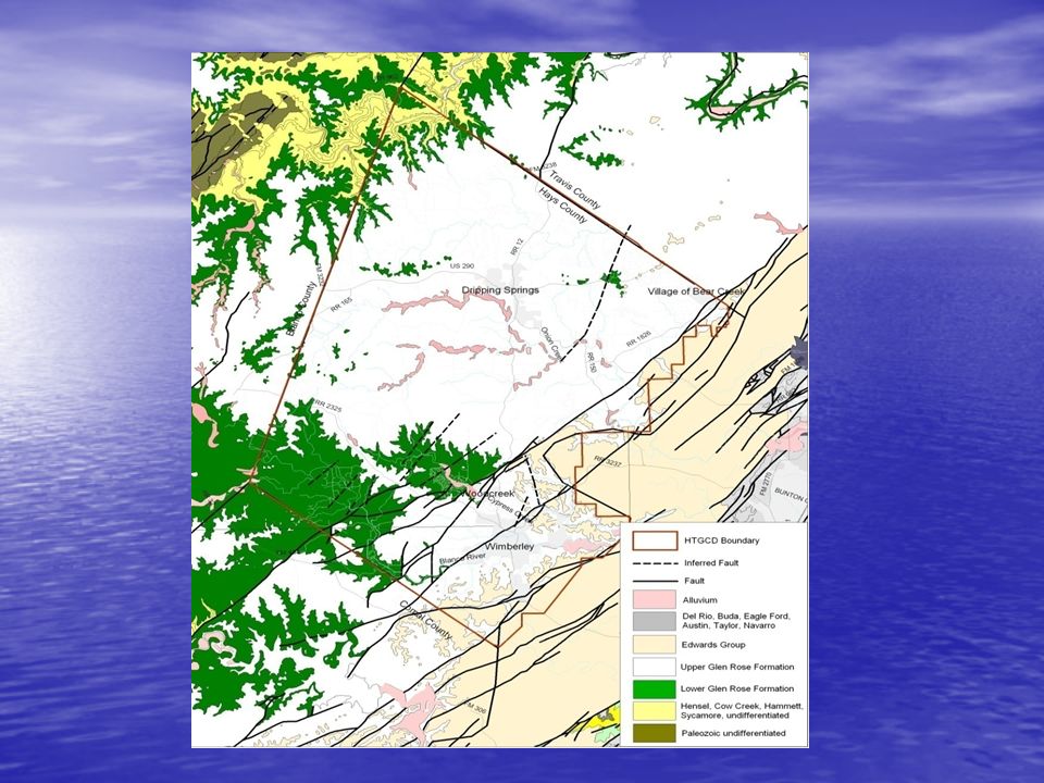
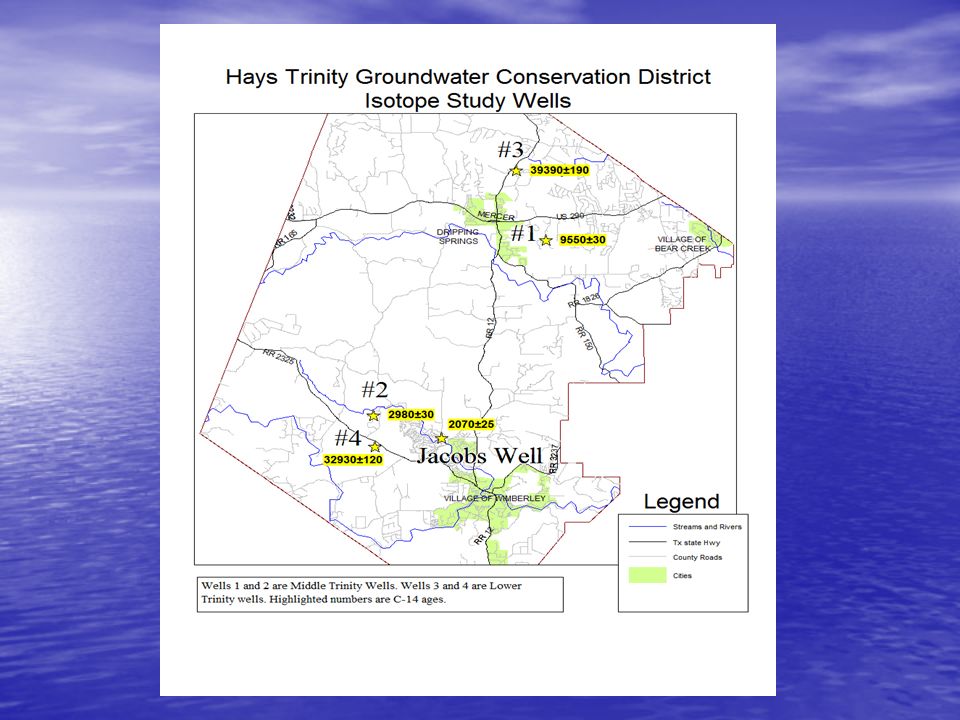
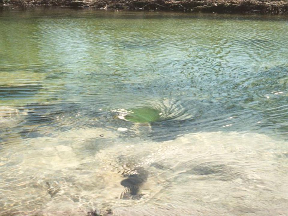
Hydrogeology of Jacob’s Well and Cypress Creek Hydrogeologic Setting Hydrogeologic Setting Sources of Water to Cypress Creek Sources of Water to Cypress Creek Base Flow from Jacob’s Well Storm Surge from Aquifer Storm Water Run-off

13
Local Stratigraphy Developed by A.S. Broun, District Geologist

15
Structural Cross Section B to B’ – Cypress Creek Drainage Lower Cretaceous Trinity Group, Hays County, Texas

16
Structural Cross Section B-B’ (cropped and enlarged)
")
20
Hydrogeology of Jacob’s Well and Cypress Creek Takeaways Base Flow from Jacob’s Well is Cypress Creek Base Flow from Jacob’s Well is Cypress Creek Base Flow originates in the Cow Creek Member of the Middle Trinity Aquifer Base Flow originates in the Cow Creek Member of the Middle Trinity Aquifer Recharge Zone is local and up dip to the west Recharge Zone is local and up dip to the west

21
Status of GMA #9 DFCs and MAGs GAM 9 has voted and approved DFCs for the Marble Falls, Ellenberger, Hickory and Edwards- Trinity (Plateau) GAM 9 has voted and approved DFCs for the Marble Falls, Ellenberger, Hickory and Edwards- Trinity (Plateau) DFC for Edwards-Trinity (Plateau) set for the preservation of stream flow in the Upper Guadalupe River and it’s tributaries DFC for Edwards-Trinity (Plateau) set for the preservation of stream flow in the Upper Guadalupe River and it’s tributaries MAG determined for the Edwards-Trinity (Plateau) MAG determined for the Edwards-Trinity (Plateau) MAG has been appealed MAG has been appealed
 GAM 9 has voted and approved DFCs for the Marble Falls, Ellenberger, Hickory and Edwards- Trinity (Plateau) DFC for Edwards-Trinity (Plateau) set for the preservation of stream flow in the Upper Guadalupe River and it’s tributaries DFC for Edwards-Trinity (Plateau) set for the preservation of stream flow in the Upper Guadalupe River and it’s tributaries MAG determined for the Edwards-Trinity (Plateau) MAG determined for the Edwards-Trinity (Plateau) MAG has been appealed MAG has been appealed")
22
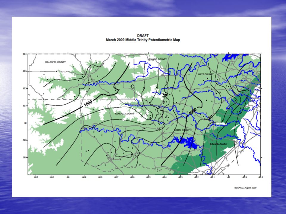
Status of GMA #9 DFCs and MAGs DFCs to be set for the Upper, Middle and Lower Trinity DFCs to be set for the Upper, Middle and Lower Trinity TWDB has performed several GAM runs at the request of GMA #9 for Upper and Middle Trinity aquifers, not Lower Trinity Aquifer TWDB has performed several GAM runs at the request of GMA #9 for Upper and Middle Trinity aquifers, not Lower Trinity Aquifer 2000 GAM vs. 2009 GAM update 2000 GAM vs. 2009 GAM update

23
Hill County Trinity GAM 2000 GAM vs. 2009 GAM 2000 GAM included Edwards Trinity Plateau, Upper and Middle Trinity Aquifers 2000 GAM included Edwards Trinity Plateau, Upper and Middle Trinity Aquifers 2009 GAM update added Lower Trinity 2009 GAM update added Lower Trinity All GAM runs to date use 2000 GAM All GAM runs to date use 2000 GAM New GAM runs with 2009 GAM in process New GAM runs with 2009 GAM in process

24
Hays Trinity Groundwater Conservation District Trinity aquifer Water Budget Based on the TWDB Edwards-Trinity aquifer GAM (in acre-feet per year) Lower Trinity aquifer – Not Included in Model Sligo & Hosston Formations Sligo & Hosston Formations Middle Trinity aquifer Lower Glen Rose Formation Hensel Sand Cow Creek Limestone Pumping Springs & Seeps (Stream Leakage ) Springs & Seeps (Stream Leakage ) Upper Trinity aquifer Upper Glen Rose Formation Recharge (rainfall infiltration) Recharge (rainfall infiltration) Trinity aquifer Edwards aquifer Loss to Edwards Aquifer (Head Dependant Bounds) Loss to Edwards Aquifer (Head Dependant Bounds) Down-gradient Movement Out of HTGCD (Horizontal Exchange) Down-gradient Movement Out of HTGCD (Horizontal Exchange) Gains to Aquifer Storage (Storage) Gains to Aquifer Storage (Storage) Hammett Shale (aquitard)
 Lower Trinity aquifer – Not Included in Model Sligo & Hosston Formations Sligo & Hosston Formations Middle Trinity aquifer Lower Glen Rose Formation Hensel Sand Cow Creek Limestone Pumping Springs & Seeps (Stream Leakage ) Springs & Seeps (Stream Leakage ) Upper Trinity aquifer Upper Glen Rose Formation Recharge (rainfall infiltration) Recharge (rainfall infiltration) Trinity aquifer Edwards aquifer Loss to Edwards Aquifer (Head Dependant Bounds) Loss to Edwards Aquifer (Head Dependant Bounds) Down-gradient Movement Out of HTGCD (Horizontal Exchange) Down-gradient Movement Out of HTGCD (Horizontal Exchange) Gains to Aquifer Storage (Storage) Gains to Aquifer Storage (Storage) Hammett Shale (aquitard)")
25
GAM Runs HTGCD Middle Trinity Steady-State (GAM Run 08-70a) 2008 Current Pumping GAM Run 08-20, 15-ft drawdown GAM Run 08-70a (25% > 2008) GAM Run 08-70b (50% > 2008) GAM Run 08-30, variable drawdown GAM Run 08-15, 35-ft drawdown
 2008 Current Pumping GAM Run 08-20, 15-ft drawdown GAM Run 08-70a (25% > 2008) GAM Run 08-70b (50% > 2008) GAM Run 08-30, variable drawdown GAM Run 08-15, 35-ft drawdown")
26
Middle Trinity – Initial Water Levels

27
Middle Trinity – 35’ Draw Down

28
HTGCD 2008 Groundwater Pumpage Total Non-Exempt Production2371 ac-ft42% Exempt Agricultural Use897 ac-ft16% Exempt Domestic Wells(330 gpd)2403 ac-ft42% TOTAL5671 ac-ft100% Upper and Middle Trinity/Lower Trinity5385/286 ac-ft Available Upper and Middle Trinity from3713 ac-ft 2005 HTGCD Management Plan
2403 ac-ft42% TOTAL5671 ac-ft100% Upper and Middle Trinity/Lower Trinity5385/286 ac-ft Available Upper and Middle Trinity from3713 ac-ft 2005 HTGCD Management Plan")
30
Drought of record, or not…

31
Do we consider the DOR, or do we close the DOR and just be average? Should we plan for average precipitation or DOR? Should we plan for average precipitation or DOR? Is sustainability always the best policy? Is it always a possible policy? Is sustainability always the best policy? Is it always a possible policy? Use of drought planning during DOR? Use of drought planning during DOR?

32
The Real Issue How does the HTGCD allocate a finite resource that has never been fully regulated in an environment where most feel it is their right to pump as much groundwater as they want. How does the HTGCD allocate a finite resource that has never been fully regulated in an environment where most feel it is their right to pump as much groundwater as they want.

33
Setting DFCs Determining MAGs By Aquifer Distributing MAGs to GCDs/Cty’s GMA Designated Reps District Management Plan 2010 District Rules & Bylaws Implementing Policies and Procedures TWC Chapter 36 Enabling Legislation TWDB GMA Public TWDB GCD Processes Joint Regional PlanningStatutes Allowable Pumping

34
Possible Allocation Strategies Management Zones Management Zones –Recognize that different aquifers and geologic conditions exist –Occurrence and maintenance of stream flow varies across District –Recharge characteristics vary across District (age of water and mining)
")
35
Possible Allocation Strategies Historical Use for Non-Exempt Wells Historical Use for Non-Exempt Wells –Water right based on some portion of past production –May be permanent or short term –May be transferable and/or marketable to other areas or other uses

36
Possible Allocation Strategies Reasonable Use for Non-Exempt Wells Reasonable Use for Non-Exempt Wells –Current permitting strategy for the HTGCD –Permits based on a “reasonable” amount of water for a specified purpose and duration

37
Possible Allocation Strategies Quantifiable Property Rights Quantifiable Property Rights –Often referred to as correlative right –Based in amount of land owned or controlled –May be transferable (marketable) to other areas or other uses –Could include multiple aquifers beneath a property
 to other areas or other uses –Could include multiple aquifers beneath a property")
38
Challenges to the HTGCD Exempt Wells - Residential Exempt Wells - Residential –Single family domestic use exempt up to 25,000 gpd –Domestic wells can be drilled on any size lot –Current pumpage estimates rely on 330 gpd that results in 42% (2403 ac-ft) of 2008 pumpage –Using the exempt “permitted” amount, domestic wells could use 182,000 ac-ft
 of 2008 pumpage –Using the exempt permitted amount, domestic wells could use 182,000 ac-ft")
39
Challenges to the HTGCD Exempt Wells –Agricultural Wells Exempt Wells –Agricultural Wells –Exempt from permitting and regulation –Vineyards and orchards are increasing and expected to continue to grow –Currently using 16% of total production

40
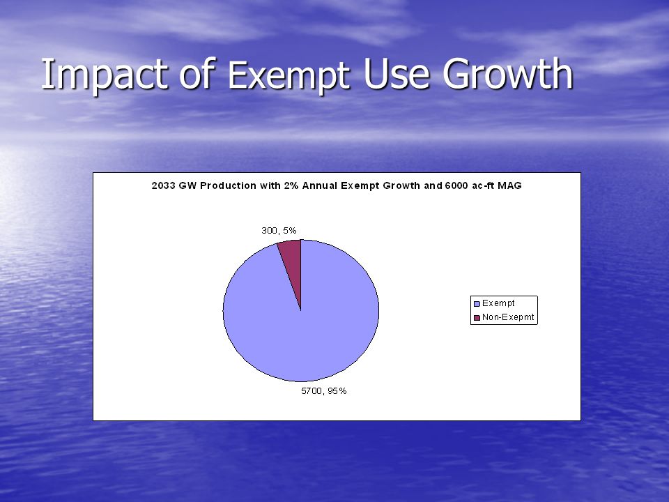
Impact of Exempt Use Growth

42
DFC Process and Cypress Creek Project HTGCD needs stakeholder feedback on desired condition of Cypress Creek HTGCD needs stakeholder feedback on desired condition of Cypress Creek –Are aesthetics of flow the primary criteria? –Is a Jacob’s Well management area necessary? –What level of flow keeps creek off the 303d list? –What is the acceptable level of risk of the creek going dry? –Is the community ready to bear the financial cost of a low risk strategy?

43
Implementation Schedule DFCs/MAGs – 1Q 2010 DFCs/MAGs – 1Q 2010 Revise Management Plan – 2Q 2010 Revise Management Plan – 2Q 2010 Adopt New Rules – 3Q 2010 Adopt New Rules – 3Q 2010 Rule Implementation – 4Q 2010 Rule Implementation – 4Q 2010 GMA 9 meets at least annually to monitor progress towards DFCs GMA 9 meets at least annually to monitor progress towards DFCs GAM 9 revisits and may reset DFCs in five years (or less?) GAM 9 revisits and may reset DFCs in five years (or less?)
 GAM 9 revisits and may reset DFCs in five years (or less )")
46
Historical Water Level Trends

47
Current Thinking of HTGCD Due to the nature of the GAM, be conservative at this time Due to the nature of the GAM, be conservative at this time Allow for MAG to be metered out to account for growth of exempt wells Allow for MAG to be metered out to account for growth of exempt wells Set up groundwater management zones in critical areas Set up groundwater management zones in critical areas Account for DOR through drought planning Account for DOR through drought planning

48
Where Does GMA-9 Go From Here? More Assessments More Public Input More Decision-making More Recommendations Complete process in 2009

Similar presentations


 1.>")


 General Law Cities (Dripping Springs; Bee Caves; Rollingwood; Buda;>")


. Required by Sec. 373.036, F.S. Goals, objectives and guidance.>")