Download presentation
Presentation is loading. Please wait.

1
GIS and Next Generation Public Safety
Norman H. Forshee, 911 Coordinator St Clair County ETSB

2
What is Next Generation 911?
Modern advancements in communications technology require a more advanced 911 system Emphasis on wireless and IP-based communication Next generation 911 system should respond anytime, anywhere, from any device

3
911 PSAPs Will Become Emergency Communications Hubs
In addition to traditional 911 callers, there are: Approximately 180 million cell phone subscribers Trucks with GPS and communications systems Devices that can provide additional data to the PSAP such as text messages, pictures, and videos Increasing numbers of voice over IP (VoIP) telephone subscribers
 telephone subscribers.")
4
Next Generation 911 System

5
Next Generation 911 Relies on GIS
Static street addresses do not apply to wireless and IP-based devices Lat/long coordinates now define a callers location

6
GIS for X/Y Routing of 911 Calls
GIS boundary files determine which 911 call center will receive a call based on the associated lat/long coordinates

7
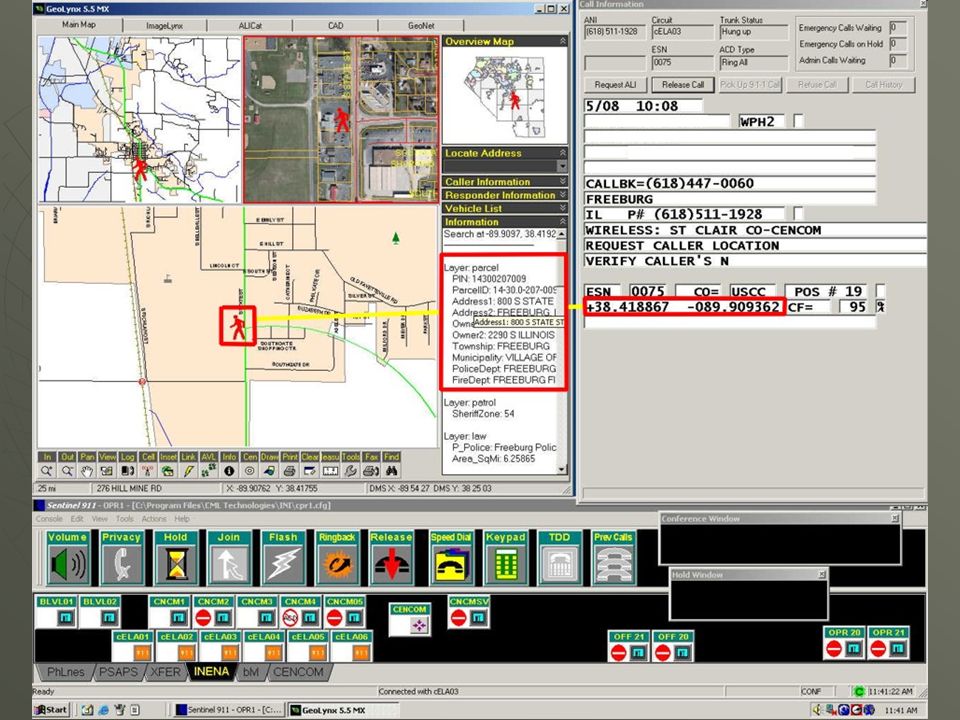
911 Telecommunicators Need GIS to Interpret Caller Location
Lat/long coordinates are not easily interpreted like a street address is Plotting the coordinates using GIS with other reference data allows for easy interpretation of relative location Responding agencies can also this access real time location data

9
Future Considerations
National routing database program for X/Y routing Standardization and local control over jurisdictional boundaries on a large scale Data standards with gap/overlap monitoring between jurisdictions

Similar presentations
 Panel Larry Amiot (Northwestern University), Chair Ben Teitelbaum (Internet2) Todd Needham (Microsoft) Orit Levin (Radvision)>")


 © 2011 Colorado 9-1-1 Resource.>")

 Emergency Call Handling Federal Communications Commission Emergency Access Advisory Committee January 14, 2011.>")


