Download presentation
Presentation is loading. Please wait.

1
Plate Boundaries Chapter 3

4
1.Divergent 2.Convergent 3.Transform

5
Rifting Buckling Shear 1.Divergent 2.Convergent 3.Transform

7
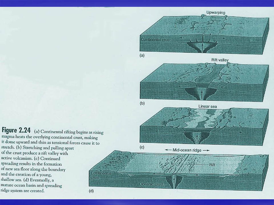
Diverging Boundaries

8
Lava fountains (10 m high) spouting from eruptive fissures during the October 1980 eruption of Krafla Volcano. (Photograph by Gudmundur E. Sigvaldason, Nordic Volcanological Institute, Reykjavik, Iceland.)
.")
14
Other evidence Hydrothermal vents (discovered in 1977) –Thermal anomalies (unusually warm water) found in 1972 over a ridge near Galapagos Islands –Sent Alvin down in 1977 Unusual organisms Pillow lavas from recently extruded ocean crust Hot water comes from seawater ventilating through the rocks Energy for life comes from geothermal energy and chemical energy comes from sea water – chemosynthetic bacteria are base of food chain
 –Thermal anomalies (unusually warm water) found in 1972 over a ridge near Galapagos Islands –Sent Alvin down in 1977 Unusual organisms Pillow lavas from recently extruded ocean crust Hot water comes from seawater ventilating through the rocks Energy for life comes from geothermal energy and chemical energy comes from sea water – chemosynthetic bacteria are base of food chain")
15
Evidence Spreading rates at transform faults –Pacific plate moves NW at 8 cm/yr –N American plate moves W at 2 cm/yr –Indian plate moves NE at 12 cm/yr Pacific Ocean is shrinking and Atlantic is growing –Atlantic opened about 200 MY ago so there should be no rocks older than this in the Atlantic

16
Most recent episode of Seafloor spreading: Pangaea first broke into 2 pieces Sea opens between N and S continents and Between Africa and Antarctica India moves North

17
S Atlantic opens Antarctica moving S India moving N Australia separates and moves N

18
50 MY in the future: 1. Africa will move N and close Mediterranean Sea 2. E Africa will detach (Red Sea rift zone) and move to India 3. Atlantic Ocean will grow and Pacific will shrink as it is swallowed into Aleutian trench. 4. W California will travel NW with the Pacific Plate (LA will be swallowed into the Aleutian trench in 60 MY).
 and move to India 3. Atlantic Ocean will grow and Pacific will shrink as it is swallowed into Aleutian trench. 4. W California will travel NW with the Pacific Plate (LA will be swallowed into the Aleutian trench in 60 MY)..")
20
Ridges

21
Mid Atlantic Ridge

22
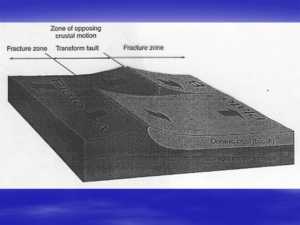
Transform Boundaries

23
Axis of spreading is broken up by curvature of earth or unequal spreading, etc Spreading cannot proceed evenly on the surface of a sphere (this would necessarily require faster spreading at the equator and slower spreading at the poles

24
Converging Boundaries Oceanic-oceanic convergence Continental-continental convergence Oceanic-continental convergence

25
Cooler, more dense slab sinks Melting of subducting slab + water and CO 2 + some mantle + some continental lithosphere

26
Converging plates 2 continental plates – e.g., Himalayas and Alps –Can get marine fossils in mountains (remember continental shelf is part of the continental lithosphere) Continental and oceanic plates – e.g., S America & N America –Mountains and island arcs 2 oceanic plates – Aleutian and Marianas trenches –Older slab (denser and cooler) sinks
 Continental and oceanic plates – e.g., S America & N America –Mountains and island arcs 2 oceanic plates – Aleutian and Marianas trenches –Older slab (denser and cooler) sinks")
30
The convergence of the Nazca and South American Plates has deformed and pushed up limestone strata to form towering peaks of the Andes, as seen here in the Pachapaqui mining area in Peru.

31
Nazca Slab

32
Island Arc Formation

34
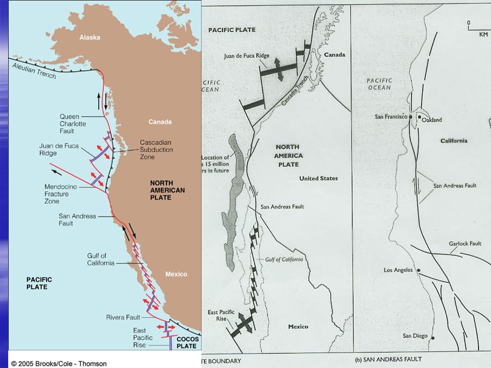
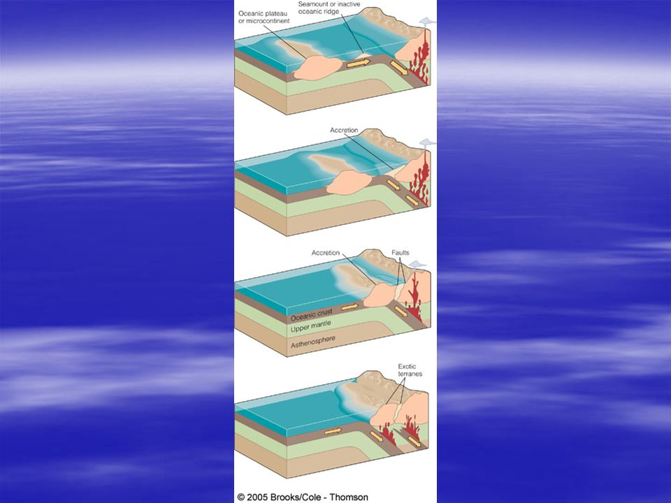
Transform faults & exotic terranes Transform faults – more next time –Plates moving past each other –Relieve pressure due to earth’s curvature, relative rates of spreading, etc Micro-plates –Small plates with plateaus or microcontinents –Get accreted onto larger continent (Pacific NW)
")
38
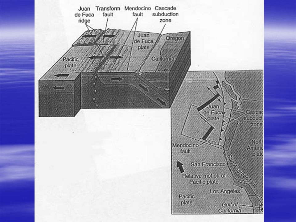
N Andreas Fault

41
Hotspots Mantle plume Direction of plate motion

45
Bands of weaker and stronger magnetic fields form mirror images on either side of spreading center. Newly formed crust records prevailing magnetic field.

46
Magnetic north is currently about 11 o offset from geographic north Compasses point to magnetic north

47
Paleomagnetism -“fossil” magnetic field is recorded as magma cools under a particular magnetic field

49
Polar wandering – magnetic pole has moved Lining up rocks in different places Based on their paleomagnetism

50
Mantle plumes -P-wave velocity anomalies -High temperature (red and yellow) -East Africa rift valleys
 -East Africa rift valleys")
51
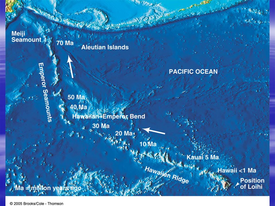
Hot spots – surface expressions of plumes Stationary spot and plate moving over it.

53
Seamounts along California's continental margin Davidson Seamount is one of several seamounts along the California continental margin. It is located about 120 km southwest of Monterey, CA, and rises to within 1300 m of the sea surface. It is oriented northeast-southwest and is a complex series of cones on parallel ridges without a summit caldera, not a typical conical shape

54
Ophiolite suites Obducted ocean crust

55
Current research Find rocks of anomalous ages in otherwise consistent time sequences relative to ridges Sediments in trenches are often in smooth layers (not disturbed and contorted). Episodic motion? Mechanism for magnetic reversals? Why don’t spreading centers move?

56
Take home points Types of plate boundaries Major seismic features of plate boundaries Location of major features (e.g., Ring of Fire, mid- ocean ridges) Tranform faults Formation and destruction of oceanic crust Function and patterns of trenches, earthquakes, mountains Lithospheric plates, hot spots, hydrothermal vents, island arcs, magnetic anomalies
 Tranform faults Formation and destruction of oceanic crust Function and patterns of trenches, earthquakes, mountains Lithospheric plates, hot spots, hydrothermal vents, island arcs, magnetic anomalies")
Similar presentations


 Mantle Outer Core Inner Core Scientists discovered these.>")


