Download presentation
Presentation is loading. Please wait.

2
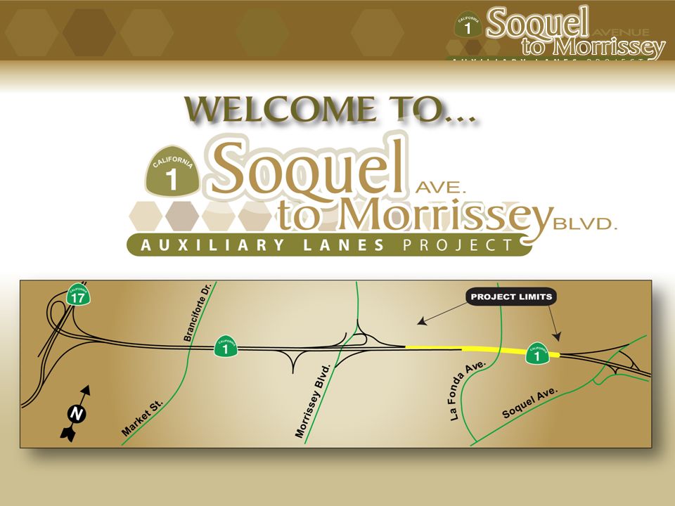
Project Location Map

3
Contents of Presentation Welcome Project Location Map Contents of Presentation Agency Involvement & Responsibilities Project Purpose & Benefits Alternatives Being Evaluated Build Alternative Map Build Alternative Description Cross Section of La Fonda Structure Public Involvement Technical Studies Being Prepared Environmental Document Process & Upcoming Activities Public Hearing Availability of Environmental Document Project Timeline Project Costs & Funding Sources How to Stay Involved

4
Agency Involvement and RESPONSIBILITIES Caltrans: The California Department of Transportation (Caltrans) is the lead state agency responsible for the environmental review under the California Environmental Quality Act (CEQA). Caltrans is also owner and operator of the California highway system. FHWA: The Federal Highway Administration (FHWA) is the lead federal agency responsible for environmental review of the highway projects under the National Environmental Policy Act (NEPA). RTC: The Santa Cruz County Regional Transportation Commission (SCCRTC) is the regional agency sponsoring this project and has secured the services of the technical consultants to assist in the preliminary design and the environmental documentation and review process under the oversight of Caltrans and the FHWA.
 is the lead federal agency responsible for environmental review of the highway projects under the National Environmental Policy Act (NEPA). RTC: The Santa Cruz County Regional Transportation Commission (SCCRTC) is the regional agency sponsoring this project and has secured the services of the technical consultants to assist in the preliminary design and the environmental documentation and review process under the oversight of Caltrans and the FHWA..")
5
Project Purpose and Benefits The purpose of the proposed project is to improve traffic conditions for lane changes and merges on Highway 1 between Soquel Avenue and Morrissey Boulevard, and improve pedestrian and bicycle access and safety. Benefits of this operational improvement project include: Improved traffic flow and operations Reduced weaving and merging conflicts Enhanced pedestrian and bicycle access via the La Fonda overcrossing Increased shoulder width will improve safety for disabled vehicles and for California Highway Patrol (CHP) enforcement Improved access for the Highway 17 Express bus service to its current end point at the Soquel Park and Ride Lot, by extending the merge lane on southbound Highway 1 all the way to Soquel Avenue requiring no merging with mainline through traffic to reach this Lot Emergency service vehicles would likewise be able to travel from Highway 17 to the Soquel Avenue off-ramp without merging with mainline through traffic
 enforcement Improved access for the Highway 17 Express bus service to its current end point at the Soquel Park and Ride Lot, by extending the merge lane on southbound Highway 1 all the way to Soquel Avenue requiring no merging with mainline through traffic to reach this Lot Emergency service vehicles would likewise be able to travel from Highway 17 to the Soquel Avenue off-ramp without merging with mainline through traffic.")
6
Alternatives Being Evaluated Build : The Build Alternative would add one 12-foot-wide auxiliary lane from the Soquel Avenue on-ramp to the Morrissey Boulevard off-ramp in the northbound direction and extend a 12-foot-wide lane from about 500 feet north of the La Fonda Avenue overcrossing to the Soquel Avenue off-ramp in the southbound direction, with 10-foot outside shoulders between the Soquel Avenue and Morrissey Boulevard interchanges. The project also would replace the La Fonda Avenue overcrossing and sidewalk improvements along Rooney Street and Morrissey Boulevard. No-Build : The No-Build Alternative would not address the project purpose and need, but offers a basis for comparison with the Build Alternative. It assumes no major construction on Highway 1 through the project limits other than planned and programmed improvements and routine maintenance. The only planned and programmed improvement contained in the 2005 Regional Transportation Plan is the State Route 1/State Route 17 Merge Lanes Project, which is currently under construction with completion set for summer 2009 or sooner.

7
Build Alternative Map

8
Build Alternative Description Caltrans and FHWA, in cooperation with RTC, are proposing the following improvements: What is an Auxiliary Lane? An auxiliary lane connects the on-ramp of one interchange to the off- ramp at the next interchange and is designed to separate traffic movements entering and exiting the freeway from mainline traffic. It is not design to be used by through traffic. An example are the outside lanes on Highway 1 between the interchanges of Bay Ave/Porter St. and 41 st Ave. Add one 12-ft-wide auxiliary lane from Soquel Avenue on-ramp to the Morrissey Boulevard off-ramp in the northbound direction Extend a 12-ft-wide lane from about 500 ft north of the La Fonda Avenue overcrossing to the Soquel Ave off-ramp in the southbound direction Reconstruct the La Fonda Avenue overcrossing with 5-ft-wide bike lanes and 6-ft-wide sidewalks on both sides of the two 12-ft-wide traffic lanes.

9
Cross Section of the La Fonda Structure Existing Proposed

10
An Informational Open House was held November 17, 2005 The purpose of the meeting was to: Public Involvement present the three alternatives that were being evaluated at that time describe the design and environmental review processes provide an opportunity to speak with and ask questions of the project team obtain input on issues to be addressed and alternatives to be considered

11
Technical Studies Prepared: Air Quality Impact Report Community Impact Assessment Cumulative Growth Inducement Study of the Highway 1 Corridor Hazardous Waste Initial Site Assessment Historic Property Survey Report Location Hydraulics Study Natural Environment Study / Wetland Assessment Noise Study Report Paleontological Evaluation Report Technical Memorandum on Energy Impacts Traffic Operations Report Visual Impact Assessment Water Quality Study Report

12
Environmental Document Process - Upcoming Activities Oct./Nov. 2008 - Draft Environmental Document Circulating to the Public (30 day Public comment period – Oct. 13 to Nov. 14) Oct. 29, 2008 - Public Hearing being held during the Public Circulation period Winter 2008 - Identify Preferred Alternative Spring 2009 – Final Environmental Document published with responses to Public Comments received during the above comment period Preliminary Design and Required Studies have been conducted and are NOW available for your review. The Environmental Document is a blended NEPA/CEQA document an “Initial Study with Proposed Mitigated Negative Declaration/Environmental Assessment”. This satisfies both the National Environmental Policy Act (NEPA) and California Environmental Quality Act (CEQA).
 Oct. 29, Public Hearing being held during the Public Circulation period Winter Identify Preferred Alternative Spring 2009 – Final Environmental Document published with responses to Public Comments received during the above comment period Preliminary Design and Required Studies have been conducted and are NOW available for your review. The Environmental Document is a blended NEPA/CEQA document an Initial Study with Proposed Mitigated Negative Declaration/Environmental Assessment . This satisfies both the National Environmental Policy Act (NEPA) and California Environmental Quality Act (CEQA)..")
13
Upcoming Public Hearing October 29, 2008 A Public Notice was published and Mailers sent out announcing the PUBLIC HEARING to be held October 29, 2008 County Government Center Board of Supervisors Chambers 701 Ocean Street, 5 th Floor Santa Cruz, CA Meeting Agenda 5:00 to 6:30 p.m. Informational Open House 6:30 to 7:30 p.m. Brief project overview followed by facilitated Public Comment 7:30 to 8:00 p.m. Resume Open House / Adjourn Public Hearing

14
Initial Study with Proposed Mitigation Negative Declaration / Environmental Assessment Website: www.dot.ca.gov/dist05/projects/soquel/draftED.pdfwww.dot.ca.gov/dist05/projects/soquel/draftED.pdf Thirty (30) Day Public Comment Period: October 13 – November 14, 2008 __________________________________________________________________________ Document to be made available along with the Technical Reports at the following locations: Caltrans District Office, 50 Higuera Street, San Luis Obispo SCCRTC, 1523 Pacific Ave. Santa Cruz, (831) 420-5661 Central Library, 224 Church Street, Santa Cruz CA 95060-3873 (831) 420-5700 Hours: Sunday 1-5, Monday- Thursday 10-8, Friday 10-5, Saturday 10-5 Branciforte Library, 230 Gault Sreet, Santa Cruz, CA 95062-2599 (831) 420-6330 Hours: Sunday Closed, Monday 1-7, Tuesday - Thursday 10-7, Friday: 1-5, Saturday 1-5 Live Oak Branch, 2380 Portola Drive, Santa Cruz, CA 95062-4203 (831) 420-5359 Hours: Sunday Closed, Monday- Thursday 10-8, Friday 12-5, Saturday 12-5 Availability of Environmental Document
 Central Library, 224 Church Street, Santa Cruz CA (831) Hours: Sunday 1-5, Monday- Thursday 10-8, Friday 10-5, Saturday 10-5 Branciforte Library, 230 Gault Sreet, Santa Cruz, CA (831) Hours: Sunday Closed, Monday 1-7, Tuesday - Thursday 10-7, Friday: 1-5, Saturday 1-5 Live Oak Branch, 2380 Portola Drive, Santa Cruz, CA (831) Hours: Sunday Closed, Monday- Thursday 10-8, Friday 12-5, Saturday 12-5 Availability of Environmental Document.")
15
Project Timeline

16
Project Costs & Funding Sources: Estimated cost: $22 Million (includes Construction and Support costs) The project has secured full funding through various sources: Federal Safe, Accountable, Flexible, Efficient Transportation Equity Act: A Legacy for Users (SAFETEA-LU) State Corridor Mobility Improvement Account (CMIA) funding made available under Proposition 1B, which was approved by voters in Nov. 2006 2006 State Transportation Improvement Program (STIP) Local Funds RTC Funds
 Local Funds RTC Funds.")
17
How to Stay Involved Read the informational materials For project updates visit the Caltrans website: www.dot.ca.gov/dist05/projects/soquel/draftED.pdfwww.dot.ca.gov/dist05/projects/soquel/draftED.pdf Read the Draft Environmental Document-released: Oct.13, 2008 Attend the Upcoming Public Hearing, October 29, 2008 We welcome your comments. If you have questions or concerns regarding the proposed project you can send your written comments to: G. William “Trais” Norris, III, Senior Environmental Planner California Department of Transportation 2015 E. Shields, Suite 100 Fresno, CA 93726 Submit comments via e-mail to: trais_norris@dot.ca.govtrais_norris@dot.ca.gov

Similar presentations


/SH 286 (Crosstown Expressway) Agency Scoping.>")

 State Water Resources Control Board Division of.>")
 Interchange Improvement Study Hoffman Estates Village Hall June 27, 2012.>")

 Meeting #1 HDR Office Tuesday, May 20, 2014 8:00 - 9:00.>")