Download presentation
Presentation is loading. Please wait.

1
Rivers: Fluvial Processes
Yukon and Charley Rivers

2
Topics 1. Introduction to fluvial processes 2. Types of channels
3. Processes associated with large meandering rivers

3
1. Introduction to fluvial processes
Streams “work” by eroding, carrying and depositing sediment

4
Solid load: suspended load & bedload (alluvium)
")
5
Suspended Load Little Colorado River

6
Large bedload, carried during monsoon rains in Nepal
Constant suspended load of glacial flour (ground up rock)
")
7
Also dissolved load

8
Suspended Load Khartoum Dissolved Load Suspended Load

9
Manaus Dissolve Load Organic Acids! Manaus Suspended Load

10
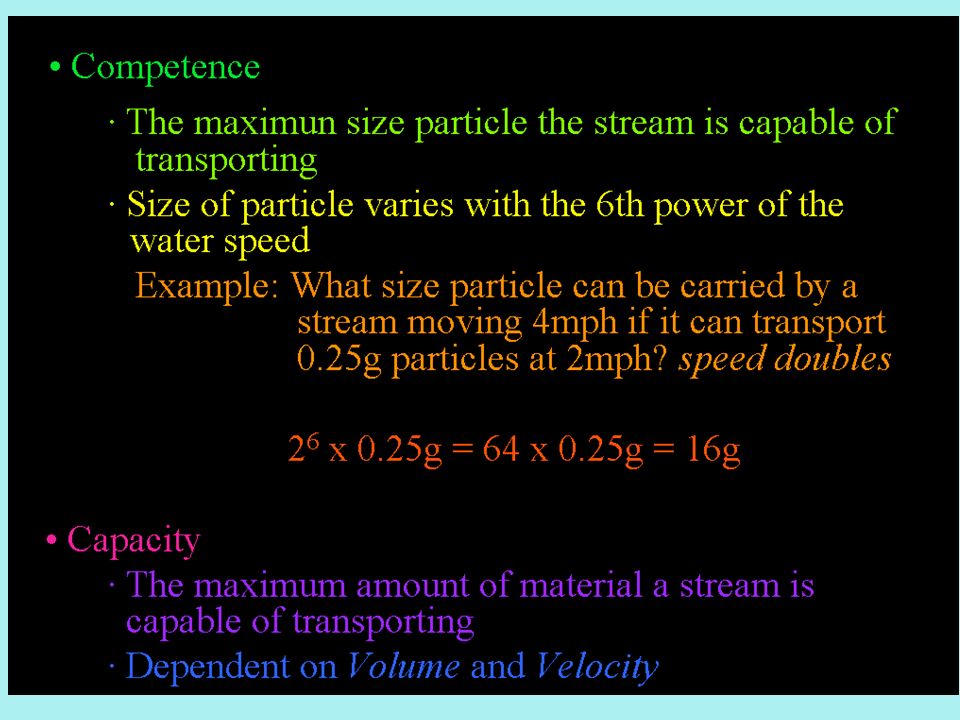
Erode? Carry? Deposit? 200 cm/s ~ 4.5 mi/hr

11
Discharge & Velocity:key

12
Elements Of Channel Formation
Elements of Channel Formation – One key function of streams is to move the products of erosion to lower, downstream locations. Erosion begins in a Source area that can involve eroding bedrock or reactivating earlier transported material. Sediment from the Source is then Transported through the stream system The channel that is formed during this Transportation process will reflect the material balance that exists. When the system has no net loss or gain of sediment (this condition is often referred to as being “In regime”), the channel will usually be relatively stable vertically but can experience considerable lateral shifting. This lateral shifting is most common in meandering streams. Finally, the sediment must be deposited somewhere within the system. This deposition often occurs just upstream of a site where Base Level Control occurs. Normally, braiding and multiple channels form in the depositional area and the stream has unstable channels. Diagram used with the permission of Geomax, P.C., Spokane, WA
, the channel will usually be relatively stable vertically but can experience considerable lateral shifting. This lateral shifting is most common in meandering streams. Finally, the sediment must be deposited somewhere within the system. This deposition often occurs just upstream of a site where Base Level Control occurs. Normally, braiding and multiple channels form in the depositional area and the stream has unstable channels. Diagram used with the permission of Geomax, P.C., Spokane, WA.")
13
Erosion in headwaters Transport in middle Deposition closer to ocean

14
High gradient (mountain) streams – erode
and carry large bedload (high competence)
")
15
High competence load creates potholes & other evidence of abrasion

17
Middle – mixture of erode, transport, deposit, and for much of the year – like this
Depends on flood or not

18
Lower end - deposit Mississippi River delta has very high capacity
(lots of sediment, Just small competence)
")
19
These are generalizations that work for larger system and not smaller pieces

20
Flow Velocity Relationships
Velocity Relationships – Sediment transport is highly sensitive to local flow velocity (turbulence). For example increasing flow velocity from 4.5 feet per sec. to 9 feet per sec. will increase the water’s transport potential from a 1 lb. rock to a 90 lb. rock. Diagram used with the permission of Geomax, P.C., Spokane, WA
. For example increasing flow velocity from 4.5 feet per sec. to 9 feet per sec. will increase the water’s transport potential from a 1 lb. rock to a 90 lb. rock. Diagram used with the permission of Geomax, P.C., Spokane, WA.")
21
Note: always concave upward profile – characteristic of streams
Even these small washes

22
Base Level & Grade Grade – concave upward profile
The ability of a stream to erode is based on velocity of water. Velocity is proportional to slope. At a sufficiently low slope, streams will run without eroding: this is called the base level. The ultimate base level is sea level, although local base levels exist, since flow paths are seldom one consistent slope.

23
Profile – concave upward
Base Level Base level is a short-term concept. Change in sea level, for instance, can either increase or decrease slope of a stream profile. Dams create artificial local base levels, and in so doing force steeper slopes (and hence erosion) downstream.
 downstream.")
24
Effects Of Dams From FEMA
Effects of Dams -- When a dam is placed on a stream, the sediment transport capability of the stream is disrupted. The dam becomes a local base level control. As the water slows at the head of the dam, any sediment that was being transported tends to be deposited and a delta is formed. The water released immediately downstream from the dam contains considerably less sediment than it did before the dam was built. This released flow is often termed “hungry water” because it usually triggers local erosion of the bed and banks of the channel below the dam. Most dams also tend to reduce peak flow by storing water during high runoff periods. Unregulated Side Drainages that enter the dammed stream also carry sediment loads. Prior to dam construction, these sediment loads normally were flushed down the main stem during peak flows. When the peak flows are reduced by the dam, the sediment coming from the side drainages cannot be flushed away as efficiently. When this happens an alluvial fan tends to form at the mouth of the unregulated side drainage. These alluvial fans then pinch the main stem flow and cause a slackwater area to develop above the fan and rapids to form in the pinched section. An additional problem develops if the dam is used as a peaking power facility. Peaking power facilities require the flow from the dam to be rapidly changed to generate power at critical times (usually in the morning at breakfast and in the evening at supper time). These rapid changes of flow cause excessive bank seepage forces to develop when rapid drawdown occurs. These seepage forces coming out of the bank often destabilize the banks and sloughing can occur. Diagram used from FEMA presentation with the permission of Geomax, P.C., Spokane, WA From FEMA
. These rapid changes of flow cause excessive bank seepage forces to develop when rapid drawdown occurs. These seepage forces coming out of the bank often destabilize the banks and sloughing can occur. Diagram used from FEMA presentation with the permission of Geomax, P.C., Spokane, WA. From FEMA.")
25
When base level drops, every tributary incises because streams are steeper and have more energy

26
When Grand Canyon formed, it “entrenched” meanders
Base level dropped ~ 5 million years ago, freezing in place the old stream patterns

27
2. Types channels 3 basic types of channel patterns: Straight Channels
Meandering channels Braided Channels

28
Straight – in nature, requires a weakness (fault, jointing) for stream
Straight – when you see, usually from human activity (channelized, Nasca, Peru)
")
29
Meandering Meandering rivers typically contain one channel that winds its way across the floodplain. As it flows, it deposits sediment on banks that lie on the insides of curves (point bar deposits), and erode the banks on the outside of curves.
, and erode the banks on the outside of curves.")
30
Point Bar Cut Bank Point Bar Cut Bank Asymmetrical

31
Meandering Streams – Streams that are vertically stable normally develop meanderings patterns. Valleys usually are wide and flat. The meander loops shift back and forth across the floodplain as the system transports the sediment load downstream that enters the valley. Meandering always flow in alluvial valleys, tend to armor their beds and create slack water deposits on the floodplain. Diagram used with the permission of Geomax, P.C., Spokane, WA

32
Braided Channel

33
Braided Rivers exhibit numerous channels that split off and rejoin each other to give a braided appearance. They typically carry coarse-grained sediment down a steep gradient

34
Braided – carries mostly bedload, so stream spreads out to bring high velocity close to bed
Meandering – carries much suspended load, so stream narrows to carry load more efficiently

35
Can get very complicated

36
3. Large Meandering Rivers

37
Meandering stream, Phnom Penh, Cambodia
Oxbow lake Point bar Cut bank

38
Zooming into a Reach Riffle Pool

39
Poor Bridge Entry Problems -- When meandering streams “fold in” on roads that cross the floodplain as shown in the previous slide, a number of problems develop. The sharp curve that occurs causes the inside of the bend to become depositional. When this happens, it is common to find a loss of conveyance dropping significantly through the bridge opening. This loss of conveyance can then cause water levels above the bridge/road crossing to become higher during periods of peak flow. Additionally, upstream bank erosion often accelerates and the bridge abutment on the outside of the bend is subjected to increased flow turbulence and can be undercut by excessive bed scour. Diagram used with the permission of Geomax, P.C., Spokane, WA

40
Bank Erosion at Cut Bank

41
Bank Erosion Newaukum River (WA)
")
42
Point Bar Deposit

43
Point bars

44
Floodplains

45
A Floodplain These are satellite images before and during Summer, 1993 floods of the Mississippi river north of St. Louis.

46
Floods In natural streams, floods occur periodically when seasonal discharges grow extremely large and waters exceed channel banks. The first thing that happens after water goes over bank is the velocity drops, and sediment is deposited. This makes natural levees along channels.

47
Yazoo Stream

48
Societal Problem Living below the river!
Cities grow & obligation to protect

49
Certainty: levee will always break. Only question: when

50
Tendency to increase meander amplitude over time

51
Tendency to increase meander amplitude over time
Rio Negro, Patagonia, Argentina

52
Tendency towards avulsion (sudden change in channel)
Sacramento R.

53
Oxbow lakes

54
Imagery seen in this presentation is courtesy of Ron Dorn and other ASU colleagues, students and colleagues in other academic departments, individual illustrations in scholarly journals such as Science and Nature, scholarly societies such as the Association of American Geographers, Geomax presentations for FEMA, city, state governments, other countries government websites and U.S. government agencies such as NASA, NPS, USGS, NRCS, Library of Congress, U.S. Fish and Wildlife Service USAID and NOAA.

Similar presentations