Download presentation
Presentation is loading. Please wait.

1
AN EVALUATION OF THE COMPATIBILITY BETWEEN NAVIGATION AND ENVIRONMENTAL RELEASES FROM THE ACF RESERVOIR SYSTEM

3
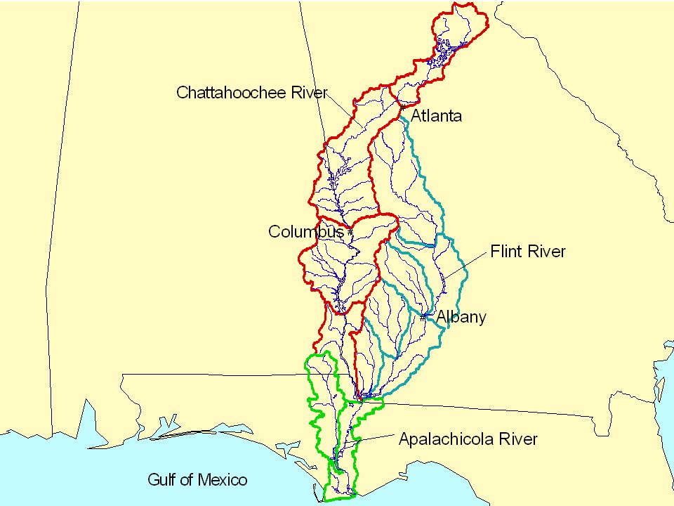
ELEVATION IN FEET 1200 1000 800 600 400 200 0 400 200 0 JIM WOODRUFF L&D APALACHICOLA RIVER MILESPROFILEAPALACHICOLAAND CHATTAHOOCHEE RIVERS Head of Navigation Head of Navigation BUFORD DAM (Lake Sidney Lanier) CHATTAHOOCHEE RIVER WEST POINT LAKE WALTER F. GEORGE L&D GEORGE W. ANDREWS L&D Atlanta, GA Columbus, GA A big river system with limited reservoir control

4
State of the System May 2011 Compacts expired 2004 IOP 2007 – ESA Drought of 2007-2008 RIOP 2008 Magnuson decisions 2010 11 th circuit appeal 2011 Draft basin manuals - 2011 On/off state negotiations ACF Stakeholders groups

5
State of the River May 2011 Navigation dead in the water while Water use continues to grow despite legal uncertainty Lack of flow targets in the mid-Chattahoochee Angst of both lake users and oyster men

6
Frustrated ? How do we get out of this?

7
RELATIONSHIP BETWEEN FLOW AND CHANNEL AVAILABILITY

8
25 Exceeded Median 75 Exceeded90 Exceeded Outflow at Jim Woodruff varying water flow levels with and without navigation releases

9
HEC RAS Channel Model

10
New Soundings

11
Mile 39

12
Conversion from HEC2

15
Channel Description No Dredging 7’ – 17,000 cfs 9’ – 21,000 cfs Reference Dredging 250,000 yards 7’ – 10,000 cfs 9’ – 14,000 cfs With about 250,000 cubic yards of dredging a 9- foot channel could be provided with 14,000 cfs flow and a 7-foot channel with 10,000 cfs flow.

16
Flow Augmentation Plan In our re-coding of the RIOP release logic in the models we included a provision of where a release is made when the 7-day basin inflow was a specified amount (x) below the required flow to provide a navigation channel. To evaluate augmentation levels multiple model runs were done at varying levels of augmentation and for varying navigation scenarios depending on the level of dredging needed to provide the channel.

17
How It Works Flow for a given channel depth Levels of augmentation Threshold flow 7 day basin inflow

18
RIOP The RIOP operations were designed to provide for the flow needs of federally listed species (sturgeon and mussels)
")
19
RIOP

20
ResSim and Stella Calibration Flows and elevations throughout the basin

21
Sensitivity Analyses Demands (current to 50% increase) Augmentation Thresholds (1,000 to 10,000 cfs) Navigation flows for different channels (9-FOOT FLOW 14,000 – 21,000 cfs) Columbus target (active vs. inactive) Used Stella for making large number of runs required for ranges of alternatives because of its quick run-time.
 Used Stella for making large number of runs required for ranges of alternatives because of its quick run-time..")
22
Navigation Patterns Navigation Season January – May Low flow period June to November – Much lower availability – Regularity of shipping service a major concern

23
Navigation Performance Measures Percentage availability by month Consecutive days with a channel Consecutive days without a channel 7 and 9 foot channels Dredging and without dredging

24
Availability of a 9-foot channel

25
Availability of a 7-foot channel

26
Mid – Chattahoochee Minimum Flows Columbus – Continuous 850 – Daily 1,350 – Weekly 1,850 Columbia – 2,000 Woodruff – 5,000

27
Mid-Chatt. Flow No set augmentation in the RIOP mode Set daily target

29
Lake Lanier RIOP – No Withdrawals RIOP - + Navigation RIOP - + 50% Increase Demands

30
Just the Highlights Report to follow

Similar presentations


 Description of Yakima River Basin and Yakima Storage Project MMS and Yakima River Basin models Global Climate-Change.>")


 Taylor Dixon, Hydrologist February 12, 2014.>")


