Download presentation
Presentation is loading. Please wait.

1
Water Systems The Water Cycle, Streams, and Ground Water

2
Earth’s Water Supply

3
Dino Pee There are around 326 million trillion gallons of water on earth. For about the past 400 million years ago, large animals have been drinking and consequently urinating large amounts of water. Assuming there has been an average of about 2 billion large animals on the earth since then…. There would be enough water for each animal to drink 1 gallon a day. I’m pretty sure the T-rex would have needed a little more than a gallon a day. Conclusion - not a drop of water you drink has not passed through another organism in the past.

4
Water Cycle water cycle the continuous movement of water between the atmosphere, the land, and the oceans More than 2/3 of Earth ’ s surface is covered with water. In the atmosphere, water occurs as an invisible gas. This gas is called water vapor. Liquid water also exists in the atmosphere as the small particles you see in clouds and fog.

5
Water Cycle Evaporation Water changing from liquid phase to a gaseous phase without boiling. Each year, about 500,000 km 3 of water evaporates into the atmosphere. That ’ s 200 million Olympic sized swimming pools.

6
Water Cycle condensation the change of state from a gas to a liquid When water vapor rises in the atmosphere, it expands and cools. As the vapor becomes cooler; some of it condenses, and forms clouds or fog.

7
Water Cycle precipitation any form of water that falls to Earth’s surface from the clouds; includes rain, snow, sleet, and hail Most precipitation falls on Earth’s oceans. The rest falls on land and becomes runoff or groundwater. Eventually, all of this water returns to the atmosphere by evaporation, condenses, and falls back to Earth’s surface to begin the cycle again.

8
Water Cycle

9
Runoff Rain that falls to the ground has two options. It can either be absorbed into the ground to become groundwater. Or it can move along the surface of the land as runoff until it flows into a stream system There are many factors that affect the amount of runoff. Runoff causes erosion.

10
Factors Affecting Runoff Rate of rain. More rain falling in a short time span will lead to more runoff. Slope of the land. A steeper slope will have more runoff. Plants. Plants and there roots help to decrease runoff. Buildings. Man-made structures tend not to absorb water well leading to more runoff.

11
River Systems tributaries streams that flows into a lake or into a larger stream watershed (AKA basin) the area of land that is drained by a river system A river system is made up of a main stream and tributaries. The ridges or elevated regions that separate watersheds are called divides.

12
Continental Divides

13
Mississippi River Basin

14
Moosehead Lake Watershed Contains 31 lakes over 549 square miles of land. With approximately 400 miles of rivers and streams. This all empties out into the Atlantic Ocean

15
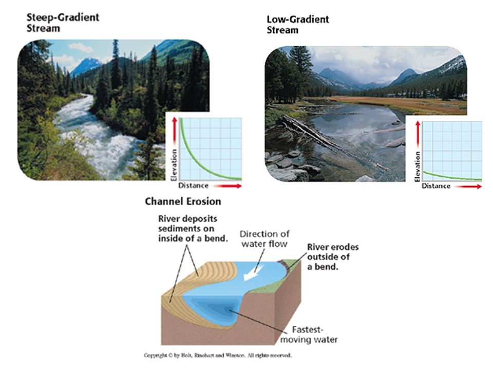
River Systems The relatively narrow depression that a stream follows as it flows downhill is called its channel. The edges of a stream channel that are above water level are called the stream’s banks. The part of the stream channel that is below the water level is called the stream’s bed. A stream channel gradually becomes wider and deeper as it erodes its banks and bed.

16
River Systems stream load the materials other than the water that are carried by a stream A stream transports soil, loose rock fragments, and dissolved minerals as it flows downhill. Stream load takes three forms: suspended load, bed load, and dissolved load.

17
Stream Load

18
River Systems Stream gradient the change in elevation over a given distance Near the headwaters, or the beginning of a stream, the gradient generally is steep. This area of the stream has a high velocity, which causes rapid channel erosion. As the stream nears its mouth, where the stream enters a larger body of water, its gradient often becomes flatter.

19
Gradient

21
River Systems River systems change continuously because of erosion. Depending on the slope of the land, streams have three stages of development. Young, Mature, and Old These differing streams support different types of organisms

22
Young Streams Young streams are those that flow swiftly through a steep valley. Young streams have lots of whitewater and waterfalls because they have not yet eroded all the material in their way. Young streams erode most on the bottom and less on the sides.

24
Stream Merging Many young streams join together to form larger streams. Sometimes these streams overfill and spread out into a larger area which slows the stream enough to deposit their sediment.

25
Floodplains floodplain an area along a river that forms from sediments deposited when the river overflows its banks The volume of water in nearly all streams varies depending on the amount of rainfall and snowmelt in the watershed.

26
Floodplains

27
Mature and Old Streams Mature and Old Streams flow through floodplains. Mature streams are curving streams that flow down a gradual slope and erode more on their sides than on the bottom. This leads to the creation of meanders.

28
Evolution of Mature Streams meander When a river rounds a bend, the velocity of the water on the outside of the curve increases. However, on the inside of the curve, the velocity of the water decreases. This decrease in velocity leads to the formation of a bar of deposited sediment, such as sand or gravel.

29
Stream Flow

30
Meandering Channels (cont) As this process continues, the curve enlarges while further erosion takes place on the opposite bank, where the water is moving more quickly. Meanders can become so curved that they almost form a loop, separated by only a narrow neck of land.

36
Horseshoe Bend of the Colorado River near Page, AZ

37
Old Streams Old streams flow very slowly through a broad flat floodplain. Often they have lost their meanders and flow more straightly.

38
Deltas and Alluvial Fans fan-shaped masses of sediment deposited as a stream slows Deltas occur where streams meet oceans Alluvial fans result where streams loose energy as the slope decreases rapidly.

41
Groundwater Water that absorbs into the ground becomes groundwater and is located in the spaces between sediments. The spaces between the sediments are called pores. These pores are connected and allow water to flow through them.

43
Permeability Permeability is the ability of a material to allow water to flow through it. Permeable rock/sediment layers allow water to pass through easily Impermeable rock/sediment layers resist the flow of water.

44
Zone of Saturation Ground water moves down until it reaches a layer of impermeable rock. Then it begins filling up the pores in the permeable rock/sediment layer called an aquifer. The area of the soil where all of the pores have completely filled with water is referred to as the zone of saturation. The upper limit of this zone is called the water table.

46
Wells Wells are holes that are dug below the water table. These give us access to clean groundwater that has been filtered by sediment. We need to provide power to get the water up to the surface. Sometimes the water table can drop and dry up the well. Having too many wells in one area increases the chances that wells could go dry during a drought.

48
Artesian Wells An artesian well is a special kind of well where water is pushed up to the surface naturally. Artesian wells require a special kind of geography where an aquifer is sandwiched between impermeable layers and the layers change in elevation. Gravity creates pressure that forces water up artesian wells.

50
Springs Springs can exist where the water table meets the surface. They can also exist when cracks allow natural artesian wells to form. Freshwater springs exist along coasts where fresh ground water enters the ocean.

52
Hot Springs and Geysers Hot springs and geysers occur where groundwater is heated by rocks that are near molten rock. Hot springs are where near boiling water leaks up to the surface. Geysers occur as boiling water and steam is periodically released causing a stream of hot water to shoot out of the ground.

54
Caves and Sinkholes Caves and sinkholes form as carbonic acid from rain water dissolves limestone. Caves are structurally stable and do no collapse. Sometimes the soil above a cave is weak and it collapses into a sinkhole. Sometimes people removing water near a cave cause the cave to become unstable, again leading to a collapse that forms a sinkhole.

56
Stalactites and Stalagmites As acidic water carrying dissolved limestone flows into a cave, the lack of CO 2 in the air causes the water to loose its carbonic acid, which causes the limestone to be deposited. If the deposit occurs on the ceiling of the cave, it is called a stalactite. If the deposit occurs on the ground of the cave it is called a stalagmite

Similar presentations