Download presentation
Presentation is loading. Please wait.

1
An OGC Interoperability for Ocean Science Gerald Creager Texas A&M University Luis Bermudez Southeastern Universities Research Association Philip Bogden SURA Coastal Ocean Observing and Prediction Program

2
Ocean Science Interoperability Experiment Open Geospatial Consortium, Inc.

3
OGC OCEANS IE Approved December 2006 by OGC Initiated March 2007 Evaluate and compare SWE/SOS/TML and WFS specifications for efficacy in distributing sensor data Provide example code and cookbooks to assist new implementers Built on the experience/expertise already derived in OOSTethys Allowed “quick-start” of the project

4
OGC OCEANS IE Key Participants SCOOP Texas A&M, GoMOOS, VIMS, SURA/SCOOP NANOOS (Bill Howe) AOOS (Rob Cermak) MBARI (John Graybeal) UNH COOA (Ru Morrison) WHOI MVCO (Janet Fredricks)
 AOOS (Rob Cermak) MBARI (John Graybeal) UNH COOA (Ru Morrison) WHOI MVCO (Janet Fredricks)")
5
OGC OCEANS IE Resources http://www.oostethys.org/ http://www.oostethys.org/ http://www.openioos.org/testbed/sos/ http://www.openioos.org/testbed/sos/ http://www.openioos.org/testbed/sos/gm_sos.html# http://www.openioos.org/testbed/sos/gm_sos.html http://www.oostethys.org/downloads/ http://www.oostethys.org/downloads/ http://www.oostethys.org/howtos/ http://www.oostethys.org/howtos/ http://www.opengeospatial.org http://www.opengeospatial.org https://portal.opengeospatial.org/files/?artifact_id=26667

6
OGC OCEANS IE Plan Develop several SOS services acceptable sensor descriptions/schemas support measurements of Salinity Temperature Others (as we determine what they are) Servers... and Clients Document development Provide data to potential developers

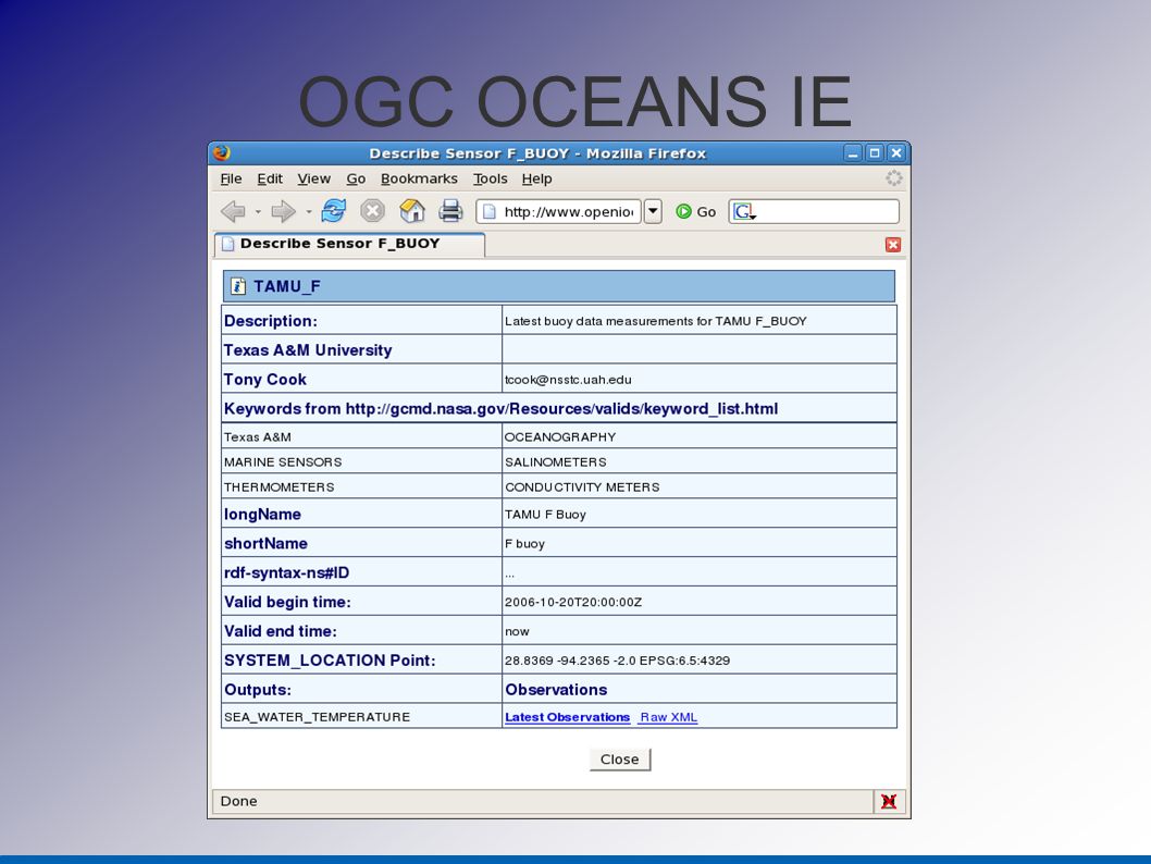
7
OGC OCEANS IE Data are accessible as graphical objects on a map http://www.openioos.org/testbed/sos/gm_sos.html http://www.openioos.org/testbed/sos/ Data are accessible as text/table Data are available as time-series presentations

8
OGC OCEANS IE

11
OGC Oceans IE

12
OGC OCEANS IE Observations Query Support WFS Version 1.1 Bounding Box: getFeature lat long; lat lon z Procedure (requires workaround) Observed Property (requires workaround) SOS Version 1.0 getObservation lat lon; lat lon z time instance/interval time interval min only time interval max only Procedure and Obs. Property supported http post required

13
OGC OCEANS IE WFS requires schema creation/definition Maintenance, versioning, extensibility, standardization SOS requires adoption of a set of specifications time/learning curve to understand specifications/standards

14
OGC OCEANS IE End products Roadmap/procedures to implement specs used (SOS, WFS) Prototype servers and clients developed Code available Reference implementations Cookbooks for developers Feedback results to OGC for specifcation update/improvement
 Prototype servers and clients developed Code available Reference implementations Cookbooks for developers Feedback results to OGC for specifcation update/improvement")
15
OGC OCEANS IE Lessons learned Adopting standards is hard Need to involve science domain expertise Beats reinventing the wheel Long-term payback potential is better than “one- off’s” Use of standards promotes innovation

Similar presentations


 OGC TC Meeting, MIT, Cambridge, MA June 22-26 2009.>")
 SWIM Application Asia/Pacific AMHS/SWIM Workshop Chaing Mai, Thailand March 5-7, 2012 Tom McParland,>")


 for INSPIRE Sylvain.>")


 Program Philip Bogden CEO, GoMOOS Director, SCOOP Program at SURA Southeastern Universities Research.>")

 a metadata content standard (International.>")


