Download presentation
Presentation is loading. Please wait.

1
Investigating: Water Circulation Channel Configuration vs Hydrodynamic Change Introducing Weirs Water Turnover Time Herve Damlamian, Jens Kruger

2
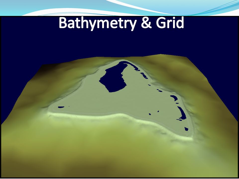
Located 225 km from Rarotonga 50 km 2 lagoon Max depth 11 m Shallow water (0 m to 3 m) largely dominant, with only few areas > 5m Arutanga channel: - Narrow : 10 m to 20 m wide - Shallow : 1 m to 5m deep
 largely dominant, with only few areas > 5m Arutanga channel: - Narrow : 10 m to 20 m wide - Shallow : 1 m to 5m deep")
4
Climate Analysis & Model Waves are Southerly dominant Mean Significant Wave High, Hs = 2.4m Wave & Wind Climate Analysis (ECMWF era interim model) Climate Scenarios Southerly Wave & Mean Easterly Wind Southeasterly Wave & mean easterly wind Northwesterly Wave & mean westerly wind No Wave & mean easterly wind Numerical model & Water circulation 4 weather scenarios * 2 (Neap & Spring)
 Climate Scenarios Southerly Wave & Mean Easterly Wind Southeasterly Wave & mean easterly wind Northwesterly Wave & mean westerly wind No Wave & mean easterly wind Numerical model & Water circulation 4 weather scenarios * 2 (Neap & Spring)")
5
High tide Low tide Water Circulation in Aitutaki Mean Condition Low tide, Secondary pattern

6
Configuration 0, 1 & 2 Configuration 1: small boat and yacht - Channel width : 50 m - Channel depth : 4 m - Marina diameter : 150 m Configuration 2: international cargo ship - Channel width : 80 m - Channel depth : 8 m - Marina diameter : 150 m

7
Comparing Conf.0 vs Conf.1 vs Conf.2 Water Circulation pattern for main weather condition Similar main water circulation patterns Similar secondary water circulation pattern Increased occurrence of secondary pattern at Spring tide Conf.0 : 1h50/day Conf.1 : 3h00/day Conf.2 :5h00/day New occurrence of secondary pattern at Neap tide. Secondary pattern results from the dominancy of tidal forcing against (hydraulic gradient + wave) forcing. Opening of Arutanga channel increases tidal forces within the lagoon and strengthens that particular water circulation pattern. (spring tide)
 forcing. Opening of Arutanga channel increases tidal forces within the lagoon and strengthens that particular water circulation pattern. (spring tide).")
8
Comparing Conf.0 vs Conf.1 vs Conf.2 Current Speed Possible impact: Disturb sediment transport rate leading to erosion

9
Comparing Conf.0 vs Conf.1 vs Conf.2 Surface Elevation 6 1 2 3 5 4 Possible Impacts: Coral species sensitive to water level fluctuation such as Micro-atoll Increase low tide exposure of reef and could potentially stress/kill coral communities Increase in lagoon water temperature: -Decrease in DO - Decline in seagrass

10
Introducing Channel Walls to Mitigate Water Level Drawdown Channel walls : Introducing Weir Structures - Emerging at low tide - No flow passing through - Allow boat to travel between the Marina and the lagoon.

11
Impact of the Implementation of Weirs on the Surface elevation

12
Impact of the Implementation of Weirs on the Current Speed - Only localized effect on Cur.spd - Water travels along the weir down to the channel entrance. - Up to 300% increase in the marina’s entrance - Up to 20% decrease in the channel mouth Possible impact: Increase sediment transport rate, erosion

13
Sc2 Conf 0 Conf 2 Conf 1 T=420 h T=135 h Lagoon Water Turnover Time Turnover time to quantify lagoon vulnerability to pollution scenario and identify areas of low water quality potential Transport model simulated a 20 days period. Eddy region: most vulnerable to pollution scenario. Opening the channel increase water turnover time (Double in Conf 2) C0nf 0Conf 1Conf 2 T0
 C0nf 0Conf 1Conf 2 T0.")
14
Conclusion 3 Circulation patterns were extracted from the model: Wave pumping, Hydraulic gradient force and wind stress, tidal flood Current Impact from channel enlargement: - Increase current speed on the south and southwest coast of Aitutaki main island (Conf 1: 50% increase ; Conf 2, 100% increase) - Lower Water level at low tide (Sc1, 1-3 cm; Sc2, 7-10 cm) Weirs set-up have negative impact as it doubles channel current speed and does not significantly prevent water level to drop. Transport model: - Channel enlargement leads to an increase in lagoon vulnerability (Double water turnover time in Conf 2). - Increase Confinement of Eddy region that can potentially decrease water quality. Cyclone threat? Improvements & Limitations
. - Increase Confinement of Eddy region that can potentially decrease water quality. Cyclone threat. Improvements & Limitations.")
15
Calibration

16
Low tide, Secondary pattern Water Circulation in Aitutaki Northwesterly wave and wind field High tide Low tide

17
Channel Current vs Scenarios - Flush out is dominant for each scenario as a result of surface elevation gradient - Maximum flush out speed: southerly wave field. - Minimum flush out speed: northwesterly wave field. - maximum channel flush in: no wave condition. - Flush in(Sc1)<Flush in(Sc2), d ue to Aitutaki geometry
<Flush in(Sc2), d ue to Aitutaki geometry.")
Similar presentations