Download presentation
Presentation is loading. Please wait.

1
Center for Hydrometeorology and Remote Sensing - University of California, Irvine Precipitation Detection and Estimation Using Multi-Spectral Remotely Sensed Data 1 Center For Hydrometeorology and Remote Sensing (CHRS), University of California, Irvine 2 NASA/GSFC Code 613.1 3 NOAA/NESDIS Center for Satellite Applications and Research (STAR), Camp Springs, MD Ali Behrangi 1 Kuo-lin Hsu 1 Bisher Imam 1 Soroosh Sorooshian 1 George Huffman 2 Robert J. Kuligowski 3

2
Center for Hydrometeorology and Remote Sensing - University of California, Irvine LEO (PMW): More accurate estimate Even after 3 hour accumulation still we have gaps GEO (VIS/IR): Less accurate estimate Global coverage is available frequently Introduction: Problem Statement
: More accurate estimate Even after 3 hour accumulation still we have gaps GEO (VIS/IR): Less accurate estimate Global coverage is available frequently Introduction: Problem Statement")
3
Center for Hydrometeorology and Remote Sensing - University of California, Irvine Introduction: Solution 1) Interpolating the precipitation intensity obtained from LEO (PMW) Satellites 2) GEO (VIS/IR) satellites provide high-resolution (time and space) images (Joyce et al., 2004)
 Interpolating the precipitation intensity obtained from LEO (PMW) Satellites 2) GEO (VIS/IR) satellites provide high-resolution (time and space) images (Joyce et al., 2004)")
4
Center for Hydrometeorology and Remote Sensing - University of California, Irvine Question: Can Multi–spectral images help us to improve GEO-based precipitation estimation ?

5
Center for Hydrometeorology and Remote Sensing - University of California, Irvine MULTI-SPECTRAL images Spinning Enhanced Visible and Infra-red Imager (SEVIRI). 12 different wavelengths once every 15 minutes,

6
Center for Hydrometeorology and Remote Sensing - University of California, Irvine The ABI (Advanced Baseline Imager) on Future GOES-R Figure courtesy of ITT Industries (Advanced Baseline Imager ) Multi- Spectral Precipitating Estimation
 on Future GOES-R Figure courtesy of ITT Industries (Advanced Baseline Imager ) Multi- Spectral Precipitating Estimation")
7
Center for Hydrometeorology and Remote Sensing - University of California, Irvine Multi- Spectral Precipitating Estimation Kurino (1997)6.7, 11 and 12 µm Rosenfeld and Gutman (1997)0.65, 3.7, 10.8 and 12 µm Inoue and Aonashi ( 2000)0.6, 1.6, 3.8, 11 and 12 µm Ba and Gruber (2001)0.65, 3.9, 6.7, 11 and 12 µm Capacci and Conway (2005) 9 MODIS and corresponding SEVIRI channels - IR 11µm & 12 µm: => removal of thin cirrus cloud - IR 11µm & WV 6.7 µm: => sign of deep convective - NIR 3.7 µm : => sensitive to cloud drop size distribution - VIS : => cloud optical thickness.
6.7, 11 and 12 µm Rosenfeld and Gutman (1997)0.65, 3.7, 10.8 and 12 µm Inoue and Aonashi ( 2000)0.6, 1.6, 3.8, 11 and 12 µm Ba and Gruber (2001)0.65, 3.9, 6.7, 11 and 12 µm Capacci and Conway (2005) 9 MODIS and corresponding SEVIRI channels - IR 11µm & 12 µm: => removal of thin cirrus cloud - IR 11µm & WV 6.7 µm: => sign of deep convective - NIR 3.7 µm : => sensitive to cloud drop size distribution - VIS : => cloud optical thickness.")
8
Center for Hydrometeorology and Remote Sensing - University of California, Irvine Relative-frequency distributions of different channels under rain and no-rain conditions No Rain Rain (0.65 μm)(3.9 μm)(6.7 μm) (10.8 μm)(13.3 μm)
(3.9 μm)(6.7 μm) (10.8 μm)(13.3 μm)")
9
Center for Hydrometeorology and Remote Sensing - University of California, Irvine Multi- Spectral Precipitating Estimation Algorithm Development: 1- Grid-box based : 2- Cloud Patch based :

10
Center for Hydrometeorology and Remote Sensing - University of California, Irvine Grid-Box Based Approach

11
Center for Hydrometeorology and Remote Sensing - University of California, Irvine Grid-box Approach Algorithm Development: Unsupervised Classification PCA A : Thick-Cold cloud (i.e., Convective) B : Thin-Cold cloud (i.e., Cirrus) C : Clear Sky Rain Probability/Intensity Multi-spectral Images Textural information Clusters (MRR)
 B : Thin-Cold cloud (i.e., Cirrus) C : Clear Sky Rain Probability/Intensity Multi-spectral Images Textural information Clusters (MRR)")
12
Center for Hydrometeorology and Remote Sensing - University of California, Irvine

13
Case Study 1: Florida : August 30 2006 Hit Under EstimationOver Estimation Ch 1 : 0.6 µm Ch2 : 3.9 µm Ch3 : 6.5 µm Ch4:10.7µm Ch5 : 13.3µm f) Ch3+Ch5 ETS=25 POD=74 FAR=45 ETS=29 POD=77 FAR=42 ETS=27 POD=78 FAR=44 ETS=36 POD=76 FAR=35 ETS=30 POD=80 FAR=42 ETS=30 POD=72 FAR=39 ETS=35 POD=79 FAR=37 ETS=37 POD=78 FAR=35 ETS=37 POD=80 FAR=36 ETS=48 POD=75 FAR=22 ETS=49 POD=79 FAR=24 g) Ch4+Ch5 i) Ch3+Ch4+Ch5 d) Ch5 f) Ch3+Ch5 VIS IR (10.8 µm)
 Ch3+Ch5 ETS=25 POD=74 FAR=45 ETS=29 POD=77 FAR=42 ETS=27 POD=78 FAR=44 ETS=36 POD=76 FAR=35 ETS=30 POD=80 FAR=42 ETS=30 POD=72 FAR=39 ETS=35 POD=79 FAR=37 ETS=37 POD=78 FAR=35 ETS=37 POD=80 FAR=36 ETS=48 POD=75 FAR=22 ETS=49 POD=79 FAR=24 g) Ch4+Ch5 i) Ch3+Ch4+Ch5 d) Ch5 f) Ch3+Ch5 VIS IR (10.8 µm)")
14
Center for Hydrometeorology and Remote Sensing - University of California, Irvine Case Study 2: Over Estimation d) Ch5 g) Ch4+Ch5 i) Ch3+Ch4+Ch5 f) Ch3+Ch5 Ch 1 : 0.6 µm Ch2 : 3.9 µm Ch3 : 6.5 µm Ch4:10.7µm Ch5 : 13.3µm
 Ch5 g) Ch4+Ch5 i) Ch3+Ch4+Ch5 f) Ch3+Ch5 Ch 1 : 0.6 µm Ch2 : 3.9 µm Ch3 : 6.5 µm Ch4:10.7µm Ch5 : 13.3µm")
15
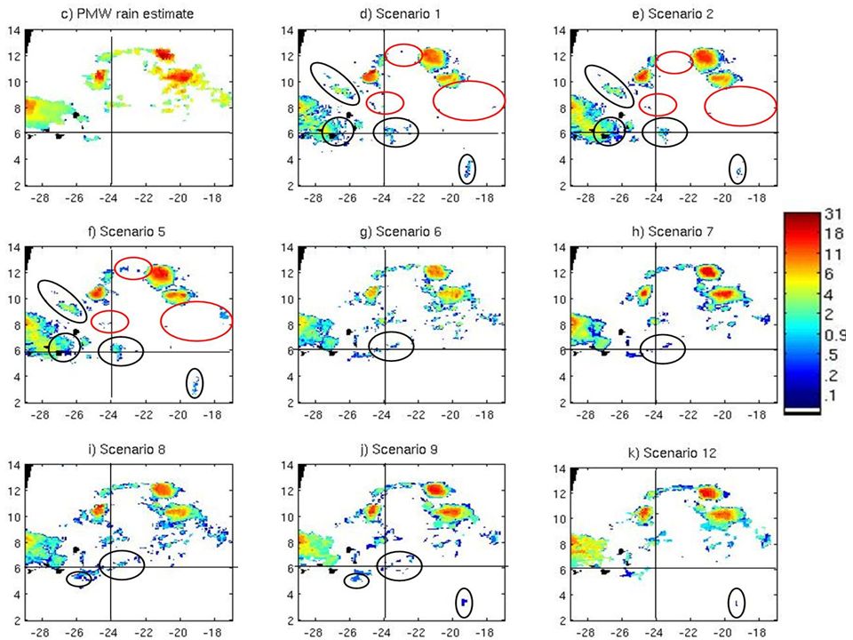
Center for Hydrometeorology and Remote Sensing - University of California, Irvine SEVIRI (MSG) VIS (0.65 µm)IR (10.8 µm) Case Study 3: Precipitation Estimation (using SEVIRI)
 VIS (0.65 µm)IR (10.8 µm) Case Study 3: Precipitation Estimation (using SEVIRI)")
16
Center for Hydrometeorology and Remote Sensing - University of California, Irvine

18
Under Estimate Over Estimate

19
Center for Hydrometeorology and Remote Sensing - University of California, Irvine Overall Results ETS POD/ FAR BIAS (area) Scenario Rain / No-rain Detection RMSE BIAS (volume) CC Scenario Rain Rate Estimation
 Scenario Rain / No-rain Detection RMSE BIAS (volume) CC Scenario Rain Rate Estimation")
20
Center for Hydrometeorology and Remote Sensing - University of California, Irvine Multi-spectral & Diurnal Cycle of Precipitation New York Florida Texas

21
Center for Hydrometeorology and Remote Sensing - University of California, Irvine BT 10.8 µm Day: BT (0.65 &10.8) µm Night: BT (6.7 & 10.8 )µm Day & Night: BT (6.7 & 10.8 )µm NEXRAD Diurnal Cycle over Florida, USA (Summer 2006)
 µm Night: BT (6.7 & 10.8 )µm Day & Night: BT (6.7 & 10.8 )µm NEXRAD Diurnal Cycle over Florida, USA (Summer 2006)")
22
Center for Hydrometeorology and Remote Sensing - University of California, Irvine Patch Based Approach

23
Center for Hydrometeorology and Remote Sensing - University of California, Irvine

24
IR-Based Patching VIS - Based Patching Multi-spectral - Patch based

25
Center for Hydrometeorology and Remote Sensing - University of California, Irvine IR-Based Patching VIS - Based Patching Warm thick cloud Cold Thin cloud Multi-spectral - Patch based

26
Center for Hydrometeorology and Remote Sensing - University of California, Irvine Results of Multi-spectral Cloud Classification experiment: In general results are encouraging ! Detail Statistics will be provided in near future

27
Center for Hydrometeorology and Remote Sensing - University of California, Irvine Conclusions: -Multi-spectral data are promising for precipitation retrieval, Particularly for delineation of areal extent of precipitation. -In addition to 10.8 μm band, VIS channel for day time and WV channel for night time seems to be good candidates. Future Work -Developing a combined algorithm using multi- spectral data and PMW estimate, …. is ongoing.

28
Center for Hydrometeorology and Remote Sensing - University of California, Irvine Thank You !

29
Center for Hydrometeorology and Remote Sensing - University of California, Irvine

Similar presentations

 Part II: Drizzle Detection.>")


 Michael J. Pavolonis.>")

, W. Feltz (UW-CIMSS), J. Sieglaff (UW-CIMSS), L. Cronce (UW-CIMSS) Objectives Develop.>")


 SQUALL LINES Author:Jochen Kerkmann (EUMETSAT)>")
 Tim Schmit Paul Menzel September 1999 National Oceanic and Atmospheric Administration NESDIS/ORA.>")


 Review 09 – 11 March 2010 CLOUD MASK AND QUALITY CONTROL FOR SST WITHIN THE ADVANCED CLEAR SKY PROCESSOR.>")