Download presentation
Presentation is loading. Please wait.

1
Ocean Zones & bathymetry
Ref: Lesson 6 in textbook

2
First a little oceanography background….

3
Ocean zones An ocean is a major body of saline water, and a principal component of the hydrosphere. Approximately 71% of the Earth's surface is covered by ocean, a continuous body of water that is divided into several principal oceans and smaller seas.

4
characteristics More than half of this area is over 3,000 meters deep.
Average oceanic salinity is around 35 parts per thousand (ppt) (3.5%). Scientists estimate that 230,000 marine life forms of all types are currently known, but the total could be up to 10 times that number.
 (3.5%). Scientists estimate that 230,000 marine life forms of all types are currently known, but the total could be up to 10 times that number.")
5
World ocean Though generally described as several 'separate' oceans, these waters comprise one global, interconnected body of salt water sometimes referred to as the World Ocean or global ocean. This concept of a continuous body of water with relatively free interchange among its parts is of fundamental importance to oceanography.

6
The major oceanic divisions (largest to smallest):
Pacific Ocean Atlantic Ocean Indian Ocean Southern Ocean Arctic Ocean Southern Ocean, which, unlike other oceans, has no landmass separating it from other oceans and is therefore sometimes subsumed as the southern portions of the Pacific, Atlantic, and Indian Oceans, which encircles Antarctica and covers much of the Antarctic Arctic Ocean, sometimes considered a sea of the Atlantic, which covers much of the Arctic and washes upon northern North America and Eurasia

7
World ocean The Pacific and Atlantic may be further subdivided by the equator into northern and southern portions. Smaller regions of the oceans are called seas, gulfs, bays, straits and other names.

8
Origin of ocean water One scientific theory about the origin of ocean water states that as Earth formed from a cloud of gas and dust more than 4.5 billion years ago, a huge amount of lighter elements (including hydrogen and oxygen) became trapped inside the molten interior of the young planet. During the first one to two billion years after Earth's formation, these elemental gases rose through thousands of miles of molten and melting rock to erupt on the surface through volcanoes and fissures (long narrow cracks).
 became trapped inside the molten interior of the young planet. During the first one to two billion years after Earth s formation, these elemental gases rose through thousands of miles of molten and melting rock to erupt on the surface through volcanoes and fissures (long narrow cracks).")
9
Origin of ocean water Within the planet and above the surface, oxygen combined with hydrogen to form water. Enormous quantities of water shrouded the globe as an incredibly dense atmosphere of water vapor. Near the top of the atmosphere, where heat could be lost to outer space, water vapor condensed to liquid and fell back into the water vapor layer below, cooling the layer. This atmospheric cooling process continued until the first raindrops fell to the young Earth's surface and flashed into steam. This was the beginning of a fantastic rainstorm that, with the passage of time, gradually filled the ocean basins.

10
Origin of ocean water Scientists calculate that this cosmic rain adds one inch of water to Earth's surface every 10,000 to 20,000 years. This amount of water could have been enough to fill the oceans if these comets have been entering Earth's atmosphere since the planet's beginning 4.5 billion years ago.

11
Why is the ocean blue? A common misconception is that the oceans are blue primarily because the sky is blue. In fact, water has a very slight blue color that can only be seen in large volumes. While the sky's reflection does contribute to the blue appearance of the surface, it is not the primary cause. The primary cause is the absorption by the water molecules' nuclei of red photons from the incoming light, the only known example of color in nature resulting from vibrational, rather than electronic, dynamics.

12
Physical properties The total mass of the hydrosphere is about 1,400,000,000,000,000,000 metric tons which is about 0.023% of the Earth's total mass. Less than 3% is freshwater; the rest is saltwater, mostly in the ocean.

13
Topic 1: bathymetry :characteristics of the ocean floor
The surfaces of the Moon and Jupiter have been mapped more thoroughly than the floor of the sea.

14
Not in notes! - The Vast Unknown
On January 7, 2005, only 400 miles from its base on Guam, the navy submarine USS San Francisco was traveling about 35 mph when it slammed into an uncharted mountain about 6,000 feet beneath the surface. One crew member died and 23 others were injured.

15
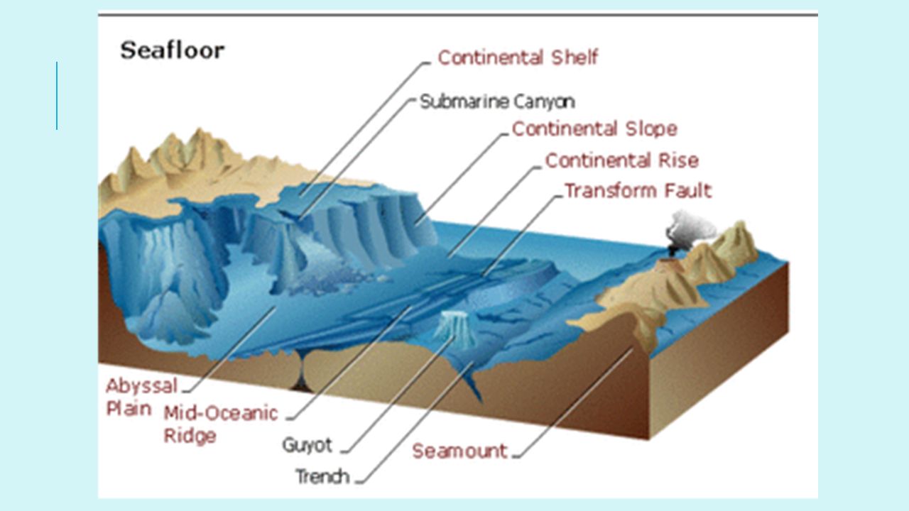
Ocean floor The familiar landscapes of continents are mirrored, and generally magnified, by similar features in the ocean basin. The largest underwater mountains, for example, are higher than those on the continents. Underwater plains are flatter and more extensive than those on the continents. All basins contain certain common features that include oceanic ridges, trenches, abyssal plains, and volcanic cones.

16
SEAFLOOR FEATURES

17
1) Continental shelf Gently sloping land area along the edges of continents
 Continental shelf Gently sloping land area along the edges of continents")
18
2) Continental slope Steep slope leading from the edge of a continent down to the seafloor
 Continental slope Steep slope leading from the edge of a continent down to the seafloor")
19
3) Continental Rise Hill of sediment at the bottom of the steep slope near the edges of continents
 Continental Rise Hill of sediment at the bottom of the steep slope near the edges of continents.")
20
4) Abyssal plains Flat, featureless plain making up a large part of the seafloor They tend to be found at depths of meters. Oceanographers believe that abyssal plains are so flat because they are covered with sediments (clay, sand, and gravel) that have been washed off the surface of the continents for hundreds of thousands of years. More extensive in Atlantic and Indian Ocean because of constant river input of sediments.
 that have been washed off the surface of the continents for hundreds of thousands of years. More extensive in Atlantic and Indian Ocean because of constant river input of sediments.")
21
5) mid-ocean ridge Underwater mountain range
Atlantic Mid-Ocean Ridge is largest in the world Enormous mountain ranges, or oceanic ridges, cover the ocean floor. The Mid-Atlantic Ridge starts at Greenland, runs down the center of the Atlantic Ocean and ends at the southern tip of the Africa. At that point, it stretches around the eastern edge of Africa, where it becomes the Mid-Indian Ridge. Some scientists say this is a single oceanic ridge that encircles Earth, one that stretches a total of more than 40,000 miles.

22
Ocean ridges (not in notes)
In most locations, oceanic ridges are 2,000 meters or more below the surface of the oceans. In a few places, however, they actually extend above sea level and form islands. Iceland, the Azores (about mi. off coast of Portugal), and Tristan de Cunha are examples of such islands.
, and Tristan de Cunha are examples of such islands.")
23
5) mid-ocean ridge Scientists believe ocean ridges are formed when magma emerges from Earth’s interior, a process known as seafloor spreading. Alfred Wegener developed continental drift theory, Pangaea Which led to Harry Hess’s proposal of seafloor spreading

24
6) trenches Deepest feature of the ocean, plunging deep below the seafloor. Trenches are long, narrow, canyon like structures, most often found next to a continental margin. They occur much more commonly in the Pacific than in any of the other oceans. The deepest trench on Earth is the Mariana Trench, which runs from the coast of Japan south and then west toward the Philippine Islands—a distance of about 1,580 miles. The British naval vessel, Challenger II surveyed the trench in 1951 and named the deepest part of the trench, the "Challenger Deep".

26
6) Trenches Its deepest spot is 11,033 meters below sea level called the Challenger Deep in the Marianas Trench. Earthquakes and volcanic activity are commonly associated with trenches. Mariana Trench Video – 45 min

28
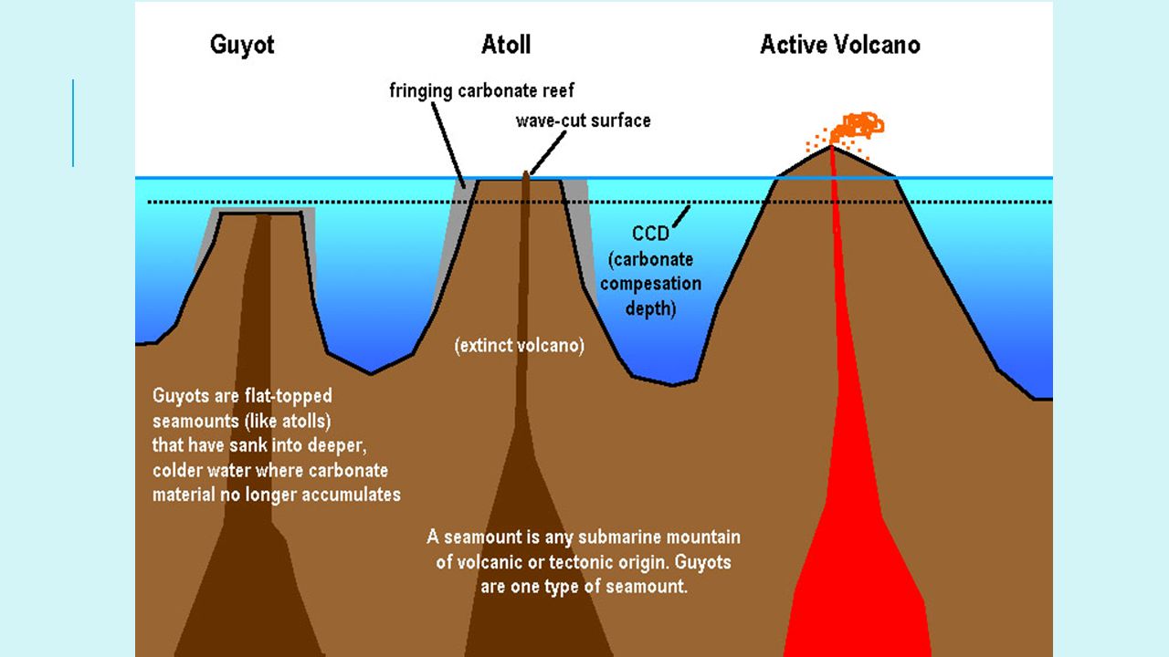
7) Volcanic cones Ocean basins are alive with volcanic activity. Magma flows upward from the mantle to the ocean bottom not only through rifts, but also through numerous volcanoes and other openings in the ocean floor. a) Seamounts are submarine volcanoes and can be either active or extinct. b) Guyots are a specific type of seamount with a flattened top. Extinct volcanoes that were once above sea level but have since receded below the surface. As they receded, wave or current action eroded the top of the volcano to a flat surface.
 Seamounts are submarine volcanoes and can be either active or extinct. b) Guyots are a specific type of seamount with a flattened top. Extinct volcanoes that were once above sea level but have since receded below the surface. As they receded, wave or current action eroded the top of the volcano to a flat surface.")
31
8) Submarine canyon Steep-sided underwater valley near the edge of a continent.
 Submarine canyon Steep-sided underwater valley near the edge of a continent.")
33
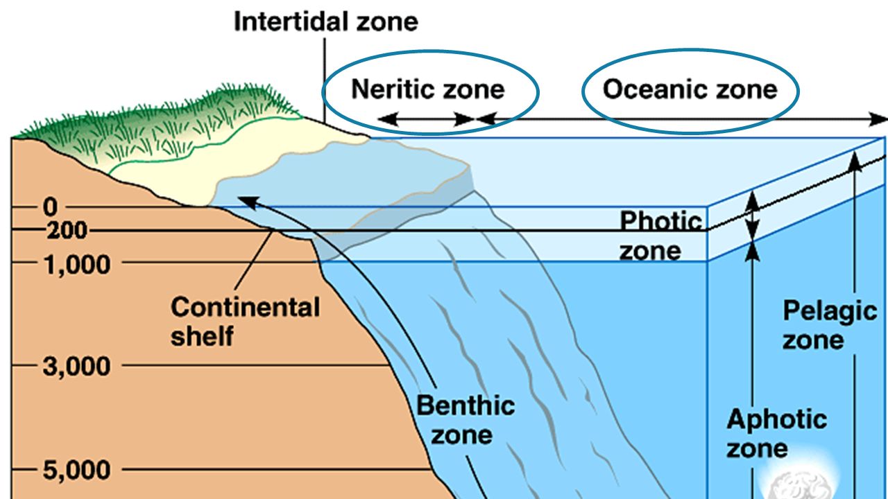
TOPIC 2: Ocean zones The ocean can be divided into two basic regions:
A. Pelagic Zone (anywhere in the water column) B. Benthic Zone (the seafloor)
 B. Benthic Zone (the seafloor)")
34
Pelagic Zone The Pelagic Zone is further divided horizontally into:
Neritic Zones – Nearshore. - large variety of conditions - Salinity can increases by evaporation, or decrease from river input - Temperature changes rapidly - Most biologically productive part of the sea Oceanic Zones – Offshore. - Open ocean - 90% of the world’s ocean

36
Pelagic zone Epipelagic zone – (0-200 meters)
Can also be divided vertically into: Epipelagic zone – (0-200 meters) Mesopelagic Zone (200–1000 meters) Bathypelagic Zone – ( meters) Abyssalpelagic Zone – ( meters) Hadalpelagic – (6000 – 10,000 meters)
 Mesopelagic Zone (200–1000 meters) Bathypelagic Zone – ( meters) Abyssalpelagic Zone – ( meters) Hadalpelagic – (6000 – 10,000 meters)")
39
splash Zone Supralittoral (splash zone) – rarely if ever covered with water Intertidal/littoral Zone – Regularly submerged and exposed with the fluctuating tide levels Sublittoral (sub – tidal) Zone – which extends to the edge of the continental shelf.
 Zone – which extends to the edge of the continental shelf.")
40
Splash zone

41
Light penetration Euphotic Zone Dysphotic Zone Aphotic Zone
Primary production occurs, light penetrates to 200m Dysphotic Zone Some light penetration, m Aphotic Zone Zero light penetration, >1000m

Similar presentations


 What is topography of the ocean?>")


 Depth = (time x 1500 m/sec)/2 (round trip) At 25 degrees.>")


