Download presentation
Presentation is loading. Please wait.

1
Providing Uncertainty: Mariner ’ s Perspective CAPT Lee Alexander, USNR (ret)
")
2
Three Aspects 1. What does “Uncertainty” mean? Hydrographer vs. Mariner Awareness and understanding 2. Use of “Thinking like a Mariner” 3. Portrayal Some considerations Some examples A Recommendation…

3
Hydrographic Uncertainty IHO S-44 - Specifies the minimum standards for hydrographic surveys So that the data collected are sufficiently accurate spatial uncertainty is adequately quantified to be safely used by mariners (as primary users of this information)
")
4
As Defined in IHO S-44 Confidence level - The probability that an error will not exceed the specified minimum value. Error - The difference between an observed or computed value of a quantity and the ideal or true value of that quantity Spatial uncertainty - [not defined]

5
S-57 ENC Product Specification Object - M_QUAL Attribute - CATZOC Attribute values - POSACC, SOUACC, & TECSOU No specific mention of uncertainty. Instead, confidence in terms of so-called “Zone of Confidence” (CATZOC) Not really a zone but an assigned category within a defined area. CATZOC “values” assigned in terms of: 1. Position accuracy 2. Depth accuracy 3. Seafloor coverage 4. Seafloor characteristics
 Not really a zone but an assigned category within a defined area. CATZOC values assigned in terms of: 1. Position accuracy 2. Depth accuracy 3. Seafloor coverage 4. Seafloor characteristics.")
6
Mariner’s Basic Assumption The charted information provided is sufficient for safe navigation.* Sufficiently accurate (depth and position) Adequately quantified Errors are known within defined confidence level spatial uncertainty is accounted for * If not, why not?
 Adequately quantified Errors are known within defined confidence level spatial uncertainty is accounted for * If not, why not")
7
The Reality… Mariners are: Less knowledgeable about charts than hydrographers.* Not really interested in the survey, itself what type, when conducted, or by who More concerned about depths known/unknown, coverage, density, and accuracy Keen to obtain information in which to make informed decisions Decision support based on current situation/task-at-hand * CAPT Robert Ward (HI “Insiders View, Sept. 04) RADM Tim McGee (USHydro 05)
 RADM Tim McGee (USHydro 05).")
8
Navigation Display Cargo Regulatory Tasks Currents Deep-sea Navigation Ship Configuration Sea State AIS Ice Human Factors Speed Weather Voyage plan Draft Manoeuvrability Chart in use Height of eye VTS Load Conditions Visibility Radar Traffic Density Coastal navigation Pilotage MIOs Time-to-go Bridge Layout Uncertainty?

9
Perceptions & Misperceptions The more soundings you see, the better the area was surveyed. The number of soundings shown are less than what is known. Soundings in deep water are less accurate than those in shallow water. Soundings are fixed, while depths are dynamic.

10
Thinking Like a Mariner Hydrographers collect and provide, while mariners “digest” and use. what may be interesting to a Hydrographer, may not be particularly useful to Mariners. more information is not necessarily better Give a Mariner good information and he/she will figure out how to use it they decide what is/is not important Good information is that which contributes to informed decision-making. interesting is not the same critical too much is often worse than too little

11
Thinking Like a Mariner (cont.) The main use is decision support (i.e., “what if” or “can I”). route/voyage planning Civil/Commercial Government/Military current situation/task-at-hand The display of uncertainty/confidence is less important than how it can/should be used. source diagrams numerical values (e.g., CATZOC) color-coded graphics
 color-coded graphics.")
12
Uses for Uncertainty/Confidence Dynamic seafloor areas Assign “changeability coefficient” (value or color scheme) Superceded Data Previous replaced with new/better Old superceded by new Higher confidence than before
 Superceded Data Previous replaced with new/better Old superceded by new Higher confidence than before")
13
Source: LT Shep Smith

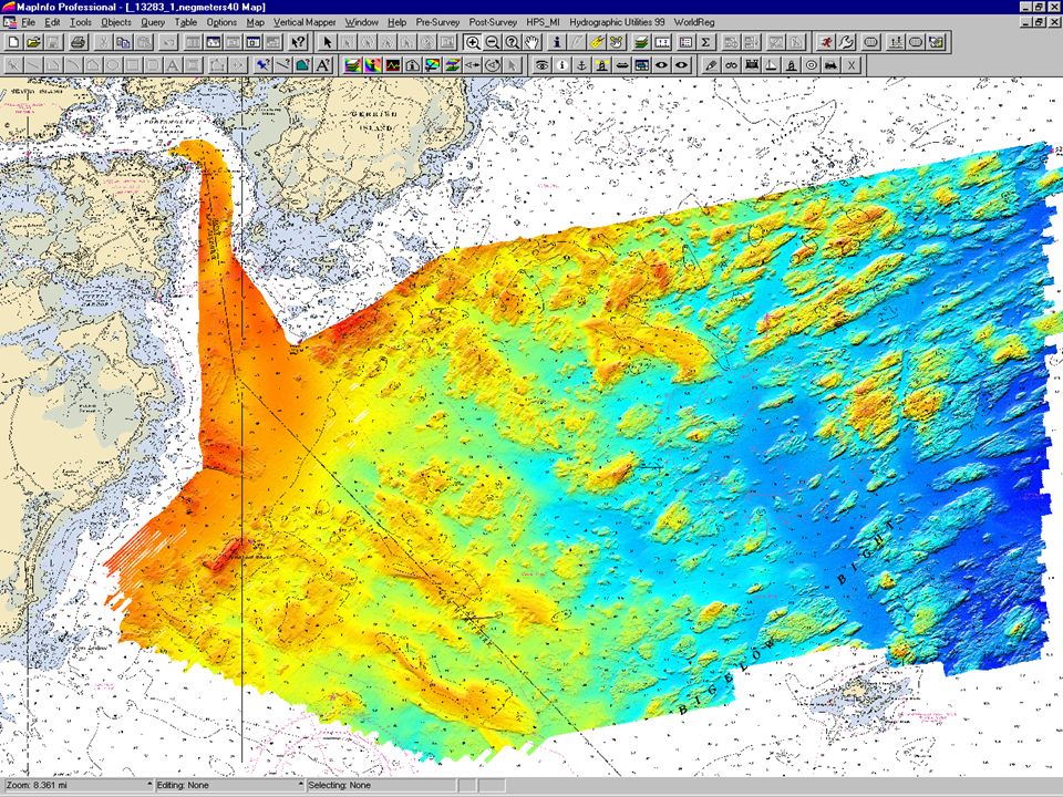
14
Depth & Uncertainty Combined Depth Grid Companion Uncertainty Grid

15
Combined Depth and Uncertainty Advantages: - intuitive - psudo-3D perspective - supplements nautical and cartographic info

16
Uncertainty Modeling Traditionally, the measurement error of a given sounding is the value reported as the uncertainty of the depth. In other words: How good was that measurement? But, what mariners really want to know is: How well is the depth known at this location?

17
Defocusing (Horizontal Error) CHS Pacific EM3000 – Esquimalt - 1m Surface defocused using 5m horizontal uncertainty estimate Source: “Total Propagated Error, BASE Surfaces and CARIS HIPS 5.4”, Lamey, B. et al., Proc. 3 rd Int. Conf. On High-Resolution Surveys in Shallow Water, Sydney, Australia, 2003.

19
Reson 8101 at Survey Density (NOAA Ship WHITING) Smoothsheet Density Shoal-Biased Selected Soundings
 Smoothsheet Density Shoal-Biased Selected Soundings")
20
Soundings Extracted from the Navigation Surface

21
Smooth Sheet Soundings from a Navigation Surface

22
Soundings and Contours from Navigation Surface

23
S-57 Ed. 3.1 ENC from Navigation Surface

24
Tide-Aware ENC 7Cs Tide Demo

25
CATZOC For most ENCs that have been produced, the assigned CATZOC value is “U” (Un-assessed) Unknown Unable Unwilling CATZOC not widely understood or used by Mariners
 Unknown Unable Unwilling CATZOC not widely understood or used by Mariners")
26
ENC Uncertainty S-57 ENC objects could be attributed with an estimated error. But,for depths: depths are defined by a variety of measurements some areas were interpolated without measurement One approach: require that the bathymetric portions of an ENC have uniform reported error. If there are areas that exceed the reported error: classified as or “poorly surveyed” assign a lower CATZOC value

27
Provision and Portrayal Strategy Recommendation: Focus on New, not Old Rather than trying to give uncertainty or confidence information on what occurred in the past (old surveys current charts), Provide new/better information that resulted from modern surveys (new surveys better charts.
, Provide new/better information that resulted from modern surveys (new surveys better charts.")
Similar presentations


 Friedhelm Moggert-Kägeler, SevenCs GmbH.>")
 Sources: Berry online text, Dawn Wright.>")


