Download presentation
Presentation is loading. Please wait.

2
Which African country is hosting 2015 Africa Cup of nations? Morocco

3
Africa Cup of Nations The 2015 Africa Cup of Nations, also known as the Orange Africa Cup of Nations Morocco 2015 is scheduled to be the 30th edition of the Africa Cup of Nations, the football championship of Africa (CAF), held from 17 January to 8 February 2015. For the second time, the tournament is scheduled to be hosted by Morocco, who previously hosted it in 1988. In October 2014, the government of Morocco requested a postponement of the tournament because of the Ebola virus epidemic in West Africa. Four host cities of the 2015 Africa Cup of Nations are Rabat, Marrakesh, Agadir and Tangier. Casablanca will serve as an alternative venue.

5
Morocco Quick Facts The official name of Morocco is the Kingdom of Morocco. Morocco is about the same size as the state of California. There are over 32 million people living in Morocco (32,649,130) as of July 2013. The capital city of Morocco is Rabat, although the largest city is Casablanca with nearly 4 million people. Other major cities in Morocco include Marrakech, Tangier, Tetouan, Salé, Fes, Agadir, Meknes, Oujda, Kenitra, and Nador. The official languages of Morocco are Berber and Arabic. The distinctive group of Moroccan Arabic dialects are collectively called Darija. French and to a lesser extent Spanish and English are also spoken in the country
 as of July The capital city of Morocco is Rabat, although the largest city is Casablanca with nearly 4 million people. Other major cities in Morocco include Marrakech, Tangier, Tetouan, Salé, Fes, Agadir, Meknes, Oujda, Kenitra, and Nador. The official languages of Morocco are Berber and Arabic. The distinctive group of Moroccan Arabic dialects are collectively called Darija. French and to a lesser extent Spanish and English are also spoken in the country.")
6
Morocco Quick Facts The currency in Morocco is called the Dirham. The southeast of the country is intersected by the Sahara Desert and direct to the south lies the Western Sahara. Morocco claims that the Western Sahara is part of its territory and refers to the area as its Southern Provinces, although officially this area is still a disputed territory. Green tea with mint and sweetened with sugar is a popular beverage in Morocco. The most famous of Moroccan dishes is couscous, other popular dishes include pastilla, tajine, and harira. Chicken is the most widely eaten meat. From 1912 to 1956, Morocco was divided into French and Spanish zones. There are just two small Spanish-controlled areas still remaining today (Ceuta and Melilla).
..")
7
Super typhoon “Phanfone” becomes the most intense storm of the year 2014, and in which country did this storm have landfall? Japan

8
Typhoon Phanfone - Japan At least one military official is dead and two are missing after being swept away by big waves when Typhoon Phanfone made landfall in Japan. About 10 people have been injured across the nation in storm-related accidents. The storm brushed past Tokyo on Monday morning, and by noon was moving rapidly north-east, clearing skies enough that Mount Fuji was clearly visible to the south-west of the city. More than 600 domestic flights have been cancelled, with Japan Airlines saying it had cancelled 19 international flights. Close to 200,000 households throughout eastern Japan were urged to evacuate due to fears of landslides or flooding as rivers threatened to burst their banks. Phanfone made landfall near the central city of Hamamatsu, prompting Honda to halt production at its Hamamatsu and Suzuka plants, while Nissan said it was halting production at its Oppama plant.

11
Japan Quick facts Area 145,834 square miles Tokyo is the capital and largest city in Japan. About 1,500 seismic events (mostly tremors) occur every year. Population 127,000,000 (U.S. is 308.7 million). 67% of the population live in cities. Language Japanese Main Exports Motor vehicles, electronic equipment, machine tools, steel, ships, chemicals, textiles, processed foods. Religion(s) Shinto; Buddhism
 occur every year. Population 127,000,000 (U.S. is million). 67% of the population live in cities. Language Japanese Main Exports Motor vehicles, electronic equipment, machine tools, steel, ships, chemicals, textiles, processed foods. Religion(s) Shinto; Buddhism.")
12
Japan Quick Facts The Japanese name for Japan is “Nihon” or “Nippon” which means “sun origin”. Japan belongs to the continent of Asia. Japan is an island nation surrounded by the Sea of Japan to the East and the Pacific Ocean to the West. Japan is made up of 6,852 islands. Some of the most well-known companies in the world are Japanese such as Toyota, Honda, Sony, Nintendo, Canon, Panasonic, Toshiba, and Sharp. Japanese cuisine has become popular around the world. Some well- known dishes are sushi, sashimi and tempura. Japan is home to many different forms of martial arts. Karate, Judo, Sumo, Ninjutsu, Kendo, Jujutsu, and Aikido to name a few. Japan hosted the 1964 Summer Olympic games in Tokyo and will again in 2020. They also hosted the 1972 and 1998 Winter Olympic Games in Sapporo and Nagano, respectively.

13
What is the name of the city on an Indonesian island where archaeologists found 40,000 year old cave paintings, which are as old as some of the other works in Europe. Maros, a city in Sulawesi province

14
Maros/Sulawesi A team of researchers reported in the journal Nature on Wednesday that paintings of hands and animals in seven limestone caves on the Indonesian island of Sulawesi may be as old as the earliest European cave art. The oldest cave painting known until now is a 40,800-year-old red disk from El Castillo, in northern Spain.

15
Maros/Sulawesi The authors of the new study, a team from Australia and Indonesia, used a uranium decay technique to date the substance that encrusts the wall paintings — a mineral called calcite, created by water flowing through the limestone in the cave. The art beneath is presumably somewhat older than the crust. The Sulawesi dates challenge the long-held view about the origins of cave art in an explosion of human creativity centered on Western Europe about 40,000 years ago, Dr. Aubert said, in an announcement issued by Griffith University.

18
Indonesia Quick Facts Population: 221,932,000 Capital: Jakarta; 13,194,000 Area: 1,922,570 square kilometers (742,308 square miles) Language: Bahasa Indonesia, English, Dutch, Javanese, and other local dialects Religion: Muslim, Protestant, Roman Catholic, Hindu, Buddhist Currency: Indonesian rupiah Industry: Petroleum and natural gas; textiles, apparel, and footwear; mining, cement, chemical fertilizers Agriculture: Rice, cassava (tapioca), peanuts, rubber; poultry Exports: Oil and gas, electrical appliances, plywood, textiles, rubber
 Language: Bahasa Indonesia, English, Dutch, Javanese, and other local dialects Religion: Muslim, Protestant, Roman Catholic, Hindu, Buddhist Currency: Indonesian rupiah Industry: Petroleum and natural gas; textiles, apparel, and footwear; mining, cement, chemical fertilizers Agriculture: Rice, cassava (tapioca), peanuts, rubber; poultry Exports: Oil and gas, electrical appliances, plywood, textiles, rubber")
19
Indonesia Facts Indonesia is officially called the Republic of Indonesia. The country of Indonesia is ethnically diverse, with around 300 distinctive native ethnic groups and over 740 different languages and dialects spoken in the country. Indonesia is part of the Malay Archipelago covering 5,150 km's (3,200 miles) east to west, between the Indian and Pacific Oceans. Scattered over either side of the equator is more than 17,500 islands, of which about 6,000 are inhabited. The largest of these islands are Sumatra, Java, Kalimantan (Indonesian Borneo), Sulawesi, and the Indonesian part of New Guinea called Papua. Indonesia is part of the Pacific Rim "Ring of Fire". The country has some 400 volcanoes, about 150 of these are active which is around 75% of all currently active volcanoes on Earth. Indonesia shares land borders with Malaysia, Papua New Guinea and East Timor.
 east to west, between the Indian and Pacific Oceans. Scattered over either side of the equator is more than 17,500 islands, of which about 6,000 are inhabited. The largest of these islands are Sumatra, Java, Kalimantan (Indonesian Borneo), Sulawesi, and the Indonesian part of New Guinea called Papua. Indonesia is part of the Pacific Rim Ring of Fire . The country has some 400 volcanoes, about 150 of these are active which is around 75% of all currently active volcanoes on Earth. Indonesia shares land borders with Malaysia, Papua New Guinea and East Timor..")
20
Indonesia Facts Indonesians are fanatical about the game of badminton, often winning gold medals at the Olympic games in the sport. Football (soccer) is also a popular sport in the country.
 is also a popular sport in the country..")
21
Cat 5 Cyclone Hudhud mainly affected which states in India? Andhra Pradesh and Odisha

22
Cyclone Hudhud Cyclone Hudhud will cross north Andhra, south Odisha on October 12 noon. The low pressure area over north Andaman that moved west- northwestwards and was intensified into a cyclonic storm 'Hudhud' on Wednesday morning will further intensify into a severe cyclonic storm during next 24 hours and eventually cross north Andhra Pradesh and south Odisha coasts between Visakhapatnam and Gopalpur. The Indian Meteorological Department (IMD) in its latest alert on late Wednesday evening said that the "system would continue to move west- northwestwards, intensify further into a severe cyclonic storm during next 24 hours and into a very severe cyclonic storm during subsequent 36 hours."
 in its latest alert on late Wednesday evening said that the system would continue to move west- northwestwards, intensify further into a severe cyclonic storm during next 24 hours and into a very severe cyclonic storm during subsequent 36 hours. .")
23
Cyclone Hudhud Under the influence of the cyclonic system, heavy to very heavy rainfall would take place over west and east Godavari, Visakhapatnam, Vijayanagaram and Srikakulam districts of north Andhra Pradesh and Ganjam, Gajapati, Koraput, Rayagada, Nabarangpur, Malkangiri, Kalahandi, Phulbani districts of south Odisha during next 48 hours. "All the central agencies are fully geared up to provide necessary assistance to these states in case of any eventualities arising out of the landfall of the cyclone expected tomorrow," a home ministry statement said here.

27
Andhra Padesh Facts ●Telugu, the official language of Andhra Pradesh, was described by Englishmen as the "Italian of the East " for its sweetness. Pingali Venkayya, who designed the Indian National Flag, was born in Bhatlapenumarru, in the Krishna district. He served in the British Indian army during the Anglo-Boer wars in South Africa. Andhra Pradesh is the largest producer of rice in the country. It also accounts for about 55% of the country's production of castor, and about 94% of Virginia tobacco. Nagarjunasagaris the world's tallest masonry dam, at a height of 124 metres, and creates a reservoir holding up to 11,472 million cubic metres. Golconda, near Hyderabad was India’s richest diamond mine. It produced renowned diamonds like: the Koh-i-Noor, the Darya-e-Nur, the Nur-Ul-Ain, the Hope diamond and the Regent diamond. Dances: Kuchipudi is a classical dance form which originated in Andhra Pradesh.

28
Odisha Facts Capital: Bhubaneswar Area: 155,707Sqkms Latitude: Between 17°49' and 22°34' North Longitude: Between 81°27' and 87°29' East Population: 3.67 crores (as per 2001 census) Average Annual Rainfall: 150 cm Language: Its Official Language is Oriya (Odia). Major Religions: Hinduism, Islam, Buddhism, Jainism, Sikhism, and Christianity Best Time to Visit: October to March Important Cities: Bhubneshwar, Konark, Puri and Cuttack Major Tourist Attractions: Jagannath Temple, Lingaraj Temple, Nandankanan Zoological Park, Raja Rani Temple and Nine Planets' Shrine Dances: The Odishi classical dance form is world famous besides fold dances such as Chhau, Chaiti Ghoda, etc. Festivals: World Famous “Chariot Festival” or “Car Festival” or Ratha Yatra is celebrated in a large way.

29
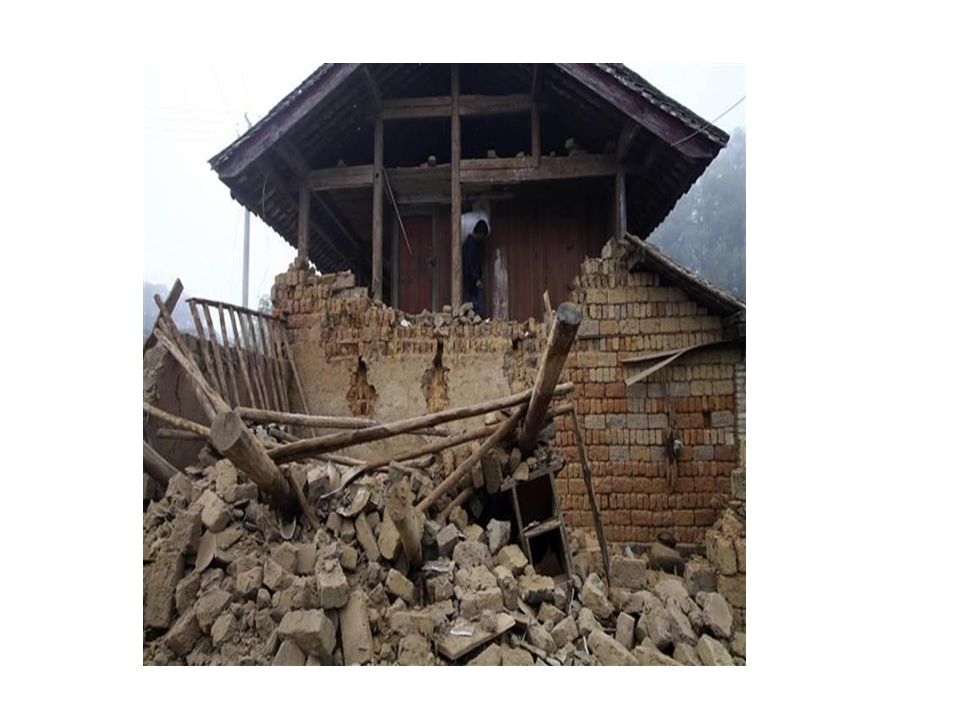
A magnitude 6.0 earthquake hits China, which province is affected by this earthquake? Yunnan province

30
Earthquake in Yunnan Province A strong 6.0-magnitude earthquake has hit southwest China's mountainous Yunnan province, the US Geological Survey (USGS) says. The quake struck at the shallow depth of 10km at 9.49pm local time on Tuesday in a region that lies close to China's borders with Myanmar and Laos. China's official Xinhua news agency said at least one person had been killed in the quake with three others injured. The epicentre was located in Jinggu County, 85km from Pu'er city, in a region famous for its tea plantations. The quake was also felt in Yunnan's provincial capital Kunming. The agency said buildings shook for several seconds, according to local officials, while some phone calls to the region went unanswered.

31
Earthquake in Yunnan Province Yunnan, a remote province, is acutely vulnerable to earthquakes. The region sees frequent seismic activity from the collision of the Indian and Eurasian tectonic plates, which form the vast Himalaya mountain range. In August, a 6.1-magnitude struck Yunnan killing more than 600 people. At least 3,143 people were injured, while more than 80,000 homes were fully or partially destroyed.

34
China Facts China is officially known as the People's Republic of China. China has the largest population in the world, with over 1.3 billion people (1,343,239,923) as of July 2012. China is the 4th largest country by area at 9,706,961 sq km (3,747,879 sq miles). China belongs to the continent of Asia. Bordering countries include Afghanistan, Bhutan, Burma, India, Kazakhstan, North Korea, Kyrgyzstan, Laos, Mongolia, Nepal, Pakistan,Russia, Tajikistan, and Vietnam. The summit of Mt Everest marks the border between China and Nepal. There are many different languages spoken in China, including Mandarin, Yue, Wu, Minbei, Minnan, Xiang, Gan and Hakka. The capital city is Beijing, while the most populated city is Shanghai. Other major cities include Chongqing, Shenzhen and Guangzhou.
 as of July China is the 4th largest country by area at 9,706,961 sq km (3,747,879 sq miles). China belongs to the continent of Asia. Bordering countries include Afghanistan, Bhutan, Burma, India, Kazakhstan, North Korea, Kyrgyzstan, Laos, Mongolia, Nepal, Pakistan,Russia, Tajikistan, and Vietnam. The summit of Mt Everest marks the border between China and Nepal. There are many different languages spoken in China, including Mandarin, Yue, Wu, Minbei, Minnan, Xiang, Gan and Hakka. The capital city is Beijing, while the most populated city is Shanghai. Other major cities include Chongqing, Shenzhen and Guangzhou..")
35
China Facts China experiences typhoons every year and also suffers from floods, tsunamis, earthquakes and droughts. China has the fourth longest river in the world, the Yangtze River, which reaches 5,797km (3,602 miles) in length. It also has the sixth longest, the Yellow River, stretching 4,667km (2,900 miles). In 2003, China became the third country to successfully send a person to space. The Great Wall of China is the largest man made structure in the world, stretching an incredible 8,850 kilometres (5,500 miles). The famous Giant Panda is found near the Yangtze River in China. China hosted the 2008 Summer Olympic Games in Beijing.
 in length. It also has the sixth longest, the Yellow River, stretching 4,667km (2,900 miles). In 2003, China became the third country to successfully send a person to space. The Great Wall of China is the largest man made structure in the world, stretching an incredible 8,850 kilometres (5,500 miles). The famous Giant Panda is found near the Yangtze River in China. China hosted the 2008 Summer Olympic Games in Beijing..")
36
President Obama designated the largest marine monument in the world recently by expanding an existing monument around US controlled islands. Name this group of unorganized and mostly unincorporated Island territories. Pacific Remote Islands Marine National Monument (PRIMNM)
.")
37
The Pacific Remote Islands Marine National Monument falls within the Central Pacific Ocean, ranging from Wake Atoll in the northwest to Jarvis Island in the southeast

38
PRIMNM The following islands constitute the Pacific Remote Islands Marine National Monument: Baker Island, an atoll in the North Pacific Ocean 1,830 nmi (3,389 km) southwest of Honolulu, about half way between Hawaii and Australia. The atoll has a total area of 129 km², of which 2.1 km² is land and 127 km² is water. (nmi – nautical mile) Howland Island, an island in the North Pacific Ocean 1,815 nmi (3,361 km) southwest of Honolulu, about half way between Hawaii and Australia. The island has a total area of 139 km², of which 2.6 km² is land and 136 km² is water. Jarvis Island, an island in the South Pacific Ocean 1,305 nmi (2,417 km) south of Honolulu, about half way between Hawaii and the Cook Islands. The island has a total area of 152 km², of which 5 km² is land and 147 km² is water.
 Howland Island, an island in the North Pacific Ocean 1,815 nmi (3,361 km) southwest of Honolulu, about half way between Hawaii and Australia. The island has a total area of 139 km², of which 2.6 km² is land and 136 km² is water. Jarvis Island, an island in the South Pacific Ocean 1,305 nmi (2,417 km) south of Honolulu, about half way between Hawaii and the Cook Islands. The island has a total area of 152 km², of which 5 km² is land and 147 km² is water..")
39
PRIMNM Johnston Atoll, an atoll in the North Pacific Ocean 717 nmi (1,328 km) southwest of Honolulu, about one-third of the way from Hawaii to the Marshall Islands. The atoll has a total area of 276.6 km², of which 2.6 km² is land and 274 km² is water. Kingman Reef, a reef in the North Pacific Ocean 930 nmi (1,722 km) south of Honolulu, about half way between Hawaii and American Samoa. The reef has a total area of 1,958.01 km², of which 0.01 km² is land and 1,958 km² is water. Palmyra Atoll, an atoll in the North Pacific Ocean 960 nmi (1,778 km) south of Honolulu, about half way between Hawaii and American Samoa. The atoll has a total area of 1,949 km², of which 3.9 km² is land and 1,946 km² is water. Wake Island, a coral atoll with a coastline of 12 miles (19 km) just north of the Marshall Islands
 south of Honolulu, about half way between Hawaii and American Samoa. The reef has a total area of 1, km², of which 0.01 km² is land and 1,958 km² is water. Palmyra Atoll, an atoll in the North Pacific Ocean 960 nmi (1,778 km) south of Honolulu, about half way between Hawaii and American Samoa. The atoll has a total area of 1,949 km², of which 3.9 km² is land and 1,946 km² is water. Wake Island, a coral atoll with a coastline of 12 miles (19 km) just north of the Marshall Islands.")
40
PRIMNM The expanded Monument will include over 130 newly protected sea mounts, which are hotspots of biodiversity that harbor uncounted numbers of new and unique marine species. The expansion will better protect the habitat of animals with large migration and foraging ranges that stretch throughout the area, including sea turtles, marine mammals, and manta rays. The Monument is also home to millions of seabirds that forage over hundreds of miles and bring food back to their rookeries on the islands and atolls. These birds serve as a conveyor belt of energy bringing nutrients caught at sea back into the near shore environment where they help sustain the ecosystems.

41
PRIMNM Commercial fishing and other resource extraction activities, such as deep sea mining, are banned in the Monument. In recognition of the importance of encouraging and supporting access to federally managed areas, recreational and traditional fishing that is consistent with the conservation goals of the Monument will continue to be allowed in the expanded Monument.

42
PRIMNM The United States long ago used the Guano Islands Act to claim islands in the middle of the Pacific Ocean as territory, which means that today the U.S. government has the legal authority to protect waters up to 200 miles out from each island, an area known as the exclusive economic zone. The following islands constitute the Pacific Remote Islands Marine National Monument: - Baker Island- Johnston Atoll - Howland Island- Kingman Reef - Jarvis Island- Palmyra Atoll - Wake Island Guano – waste product from birds or cave dwelling bats. As a manure, guano is a highly effective fertilizer due to its exceptionally high content of nitrogen, phosphate, and potassium, three nutrients essential for plant growth. digestive tract.

43
At least nine people have died in a boat accident, with about 30 people still missing. In which African country did this boat accident take place recently? Guinea

44
Guinea Boat Accident At least nine people have died in a boat accident in Guinea, with about 30 people still missing, officials and residents say. The boat capsized near the Forecariah district, in the country's south. Eighteen people on board were rescued. A local security source told AFP news agency that the boat had collided with a mining ship. Eighteen people were rescued and survived, he said. Local authorities were continuing to search for victims of the accident as night fell. Boat accidents are common off Guinea's coast, with overcrowding and poor safety standards thought to be factors. Boats are a common form of transport in the country's coastal areas. Guinea is among the west African countries currently battling an Ebola outbreak, which has killed over 4,000 people.

46
Guinea Quick Facts Population: 9,453,000 Capital: Conakry; Area: 245,857 square kilometers (94,926 square miles) Language: French, local languages Religion: Muslim, Christian, indigenous beliefs Currency: Guinean franc Industry: Bauxite, gold, diamonds, alumina refining, light manufacturing Agriculture: Rice, coffee, pineapples, palm kernels; cattle; timber Exports: Bauxite, alumina, gold, diamonds, coffee Guinea shares its northern border with Guinea-Bissau, Senegal and Mali and its southern border with Liberia, Sierra Leone and Cote d’Ivoire The climate is predominantly humid and hot. The monsoonal rains are from June to November and the dry season is from December to May when they experience north easterly harmattan winds. Guinea gained independence from France on October 2 1958 and this is celebrated every year as the National day of the Republic of Guinea.

47
Which South American country is having a drought, which is impacting coffee industry? Brazil

48
Brazil Drought The governor of the Brazilian state of Sao Paulo has asked for emergency clearance to siphon the remaining water out of the main reservoir serving Sao Paulo city, which has almost run dry. After nine months of unprecedented drought, 95% of the water has gone. Twenty-nine other Brazilian cities have been affected by the drought. In Sao Paulo's main reservoir, the Cantareira system, the fall in the level has exposed a cracked earth landscape littered with the wrecks of dozens of old cars dumped over the years. The drought has also affected other states. Rio de Janeiro and Minas Gerais are locked in an increasingly hostile battle over water resources, since Sao Paulo - the economic power engine of Brazil - is trying to draw water from a river system that also serves these other two states.

49
Brazil Drought Brazil is the world's biggest coffee producer, accounting for about a third of global production. It produces more than half of the world's arabica coffee - the most popular bean used in espressos and cappuccinos globally. So the drought has had an impact on prices. And it has coincided with a leaf rust that has damaged crops in Central America, further hiking up prices.

52
Brazil Quick Facts Brazil is the largest country in South America. The name Brazil comes from a tree named brazilwood. It is called Brasil in Portuguese, the official language spoken in Brazil. Brazil is the only country in South America that speaks Portuguese. Portugal claimed the land of Brazil in the year 1500. Independence was declared in 1822. Brazil is the 5th largest country in the world by both land area and population. The capital city is Brasilia, while the largest city is Sao Paulo. Other major cities include Rio de Janeiro, Salvador and Fortaleza. In Brazil they drive on the right-hand side of the road. Brazil has a large coastline on the eastern side of South America, stretching 7491 kilometres (4655 miles) in length.
 in length..")
53
Brazil Quick Facts Brazil shares a border with all South American countries except for Chile and Ecuador. Brazil covers 3 time zones. Brazil has one of the largest economies in the world. Brazil is one of the 77 founding members of the United Nations. The Amazon River flows through Brazil, it is the 2nd longest river in the world (after the Nile). Football (soccer) is the most popular sport in Brazil with the national team consistently among the best in the world, winning the World Cup a record 5 times.
. Football (soccer) is the most popular sport in Brazil with the national team consistently among the best in the world, winning the World Cup a record 5 times..")
Similar presentations