Download presentation
Presentation is loading. Please wait.

1
Includes acquisition of aerial and satellite imagery and geochronology. Part of the EarthScope Facility project funded by NSF (MREFC). Managed at UNAVCO. Assist with EarthScope instrument siting. Examine strain field at different temporal/spatial scales than geodetic & seismic instrumentation. Data will be freely available. GeoEarthScope
. Managed at UNAVCO. Assist with EarthScope instrument siting. Examine strain field at different temporal/spatial scales than geodetic & seismic instrumentation. Data will be freely available. GeoEarthScope.")
2
GeoEarthScope Poster

3
InSAR Yuri Fialko* Falk Amelung Gerald Bawden Ben Brooks Craig Dobson Andrea Donnellan Jeff Freymueller Francisco Gomez Zhong Lu Tim Melbourne Kurt Feigl Gilles Peltzer Mary Hubbard* Ramon Arrowsmith James Beget Anne Blythe Eric Kirby David Mogk Tom Rockwell David Schwartz James Spotila Geochron Kevin Furlong* Ron Bruhn Doug Burbank James Dolan John Oldow Carol Prentice Charlie Rubin Brian Wernicke Steve Wesnousky LiDAR Federal government employees are non-voting observers Working Groups Mark Simons* Roland Burgmann Michael Oskin Susan Owen Fred Phillips Overview *Chair

4
GeoEarthScope LiDAR goals are based on recommendations provided by LiDAR Working Group on behalf of community WG report available online at http://earthscope.org and http://unavco.org/geo earthscope http://earthscope.org http://unavco.org/geo earthscope WG Reports

5
Technique, Lab (Lab Manager), Award Amount 14CLLNL (Guilderson) $50,000 14C UC Irvine (Southon) $50,000 OSLUtah State (Rittenour) $50,000 OSL U. of Washington (Feathers) $50,000 CosomogenicU. of Kansas (Walker) $50,000 CosomogenicPRIME Lab (Caffee) $150,000 (U-TH)/HeU. of Arizona (Reiners) $120,000 Fission TrackAtoZ (Donelick) $60,000 40Ar/39ArNew Mexico Tech (Heizler) $40,000 40Ar/39ArBerkeley Geochron Ctr (Renne)$40,000 40Ar/39ArU. of Florida (Foster) $40,000 U-PbMIT (Bowring) $100,000 Techniques, labs, awards determined by RFP process and recommendations from working group. Geochronology Labs
 $50,000 CosomogenicU. of Kansas (Walker) $50,000 CosomogenicPRIME Lab (Caffee) $150,000 (U-TH)/HeU. of Arizona (Reiners) $120,000 Fission TrackAtoZ (Donelick) $60,000 40Ar/39ArNew Mexico Tech (Heizler) $40,000 40Ar/39ArBerkeley Geochron Ctr (Renne)$40,000 40Ar/39ArU. of Florida (Foster) $40,000 U-PbMIT (Bowring) $100,000 Techniques, labs, awards determined by RFP process and recommendations from working group. Geochronology Labs.")
6
Q: I am preparing a proposal to submit to NSF. How do I request access to GeoEarthScope geochronology facilities/credits? A: NSF will award geochronology credits based on proposals submitted via the merit review proposal process. Proposals may include specific requests to access geochronology credits [but such requests will have no direct influence on NSF award decisions]. On the other hand, successful proposals may have geochronology credits issued to them even if the proposals did not request this. NSF award decisions will be science-based, not credit-based. Geochronology Credits

7
Q: I still have questions regarding geochronology credits and my proposal. Who should I contact for additional information? A: Investigators preparing NSF proposals should contact Kaye Shedlock, EarthScope Program Director, at NSF (kshedloc@nsf.gov). General question may also be directed to David Phillips, GeoEarthScope Manager, at UNAVCO (phillips@unavco.org). Geochronology Credits

8
InSAR Recommendations

9
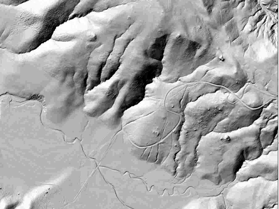
Flown by NCALM Mar-Apr 2007 GPS “heavy” data collected by OSU, UNAVCO, volunteers Complementary to B4 project Benefited from B4 experiences Overlaps with B4 Significant community involvement Core targets identified by GeoES working group with input from research community Supplemental targets were funded by USGS, SF PUC, City of Berkeley Northern California LiDAR ENTIRE SAN ANDREAS HAS NOW BEEN IMAGED WITH HIGH RESOLUTION AIRBORNE LIDAR!

10
Southern Creeping

12
Hayward

13
Death Valley-Fish Lake Valley PI: James Dolan, USC Flown by NCALM Nov-Dec 2006 LiDAR Projects

14
Additional GeoES LiDAR projects planned for: Southern/eastern California Intermountain Seismic Belt Pacific Northwest Alaska Future LiDAR Projects

15
Elsinore => (138km x 1km)+ (16km x 4km at step overs in middle section) = 202 sq. km Garlock => (223km x 1km)+ (16km x 3.5km at Koehn Lake)+ (9.5km x 3km)+ (26km x 3.5km at eastern section of Garlock) = 398.5 sq. km Panamint Valley, Hunter Mountain, Saline Valley faults => (125.5km x 1km)+ (50km x 1.5km in Saline Valley) = 200.5 sq. km Ash Hill fault => (29km x 1km)+ (7km x 1.5km in southern section) = 39.5 sq. km Owens Valley fault => (26km x 3km in northern section) + (69km x 1km) + (26km x 2km in southern section) = 199 sq. km San Cayetano fault => 40km x 2km = 80 sq. km Lenwood fault => 53km x 1km = 53 sq. km Calico fault => 21km x 1km = 21 sq. km Total area: 1193.5 sq. km Southern / Eastern California LiDAR
+ (16km x 3.5km at Koehn Lake)+ (9.5km x 3km)+ (26km x 3.5km at eastern section of Garlock) = sq. km Panamint Valley, Hunter Mountain, Saline Valley faults => (125.5km x 1km)+ (50km x 1.5km in Saline Valley) = sq. km Ash Hill fault => (29km x 1km)+ (7km x 1.5km in southern section) = 39.5 sq. km Owens Valley fault => (26km x 3km in northern section) + (69km x 1km) + (26km x 2km in southern section) = 199 sq. km San Cayetano fault => 40km x 2km = 80 sq. km Lenwood fault => 53km x 1km = 53 sq. km Calico fault => 21km x 1km = 21 sq. km Total area: sq. km Southern / Eastern California LiDAR.")
16
Acknowledgements Ken Hudnut NCALM GeoEarthScope working groups

18
Q: Are there guidelines that should be followed if I would like to specifically request access to geochronology credits in my proposal? A: No. NSF award decisions will be science-based, not credit-based. Q: Would it be detrimental to my proposal if I requested support for geochronology analyses not available from GeoEarthScope facilities? A: No. NSF award decisions will be science-based, not credit-based. Geochronology Labs

19
Q: Can GeoEarthScope credits be used to support geochronology field work and sample collection? A: No. Credits can only be used for “analysis”. Q: Geochronology credits are not mentioned in NSF Solicitation 06-562. Will the GeoEarthScope geochronology credits still be available for proposals submitted for the July 16, 2007 deadline? A: Yes. Geochronology Labs

20
Budget The overview panel’s report, submitted to UNAVCO in summer 2007, recommended the following funding distribution: LiDAR, $1.9M InSAR, $1.1M Geochronology, $0.8M UNAVCO is currently implementing GeoEarthScope activities based on these recommendations

Similar presentations


, Interseismic strain accumulation and anthropogenic motion in metropolitan Los.>")


>")
 a confluence of interests Ken Hudnut U. S. Geological Survey, Pasadena.>")

 Co-PIs: J Ramon Arrowsmith.>")