Download presentation
Presentation is loading. Please wait.

1
Numerical Prediction of High-Impact Local Weather: How Good Can It Get? Kelvin K. Droegemeier Regents’ Professor of Meteorology Vice President for Research University of Oklahoma 2013 Congress 19 April 2013

3
n Agriculture $135.8B (100%) n Oil and Gas Extraction $99.5B (100%) n Construction $463.6B (100%) n Transportation $786.5B ( 95%) n Retail Trade $893.9B (100%) n State/Local Government $829.5B (100%) n Others n Total$3.86T ( 40%) 40% of the $10T U.S. Economy is Impacted by Weather and Climate

4
n 876 deaths annually due to severe weather n 7000+ weather-related traffic fatalities n 450,000 weather-related traffic injuries A Great Toll in Human Life

5
About 50% of the loss is deemed preventable with better weather and climate forecasts!

6
Copyright © 2003 WGN-TV Computer Models are the Primary Source of Information for All Weather & Climate Predictions

7
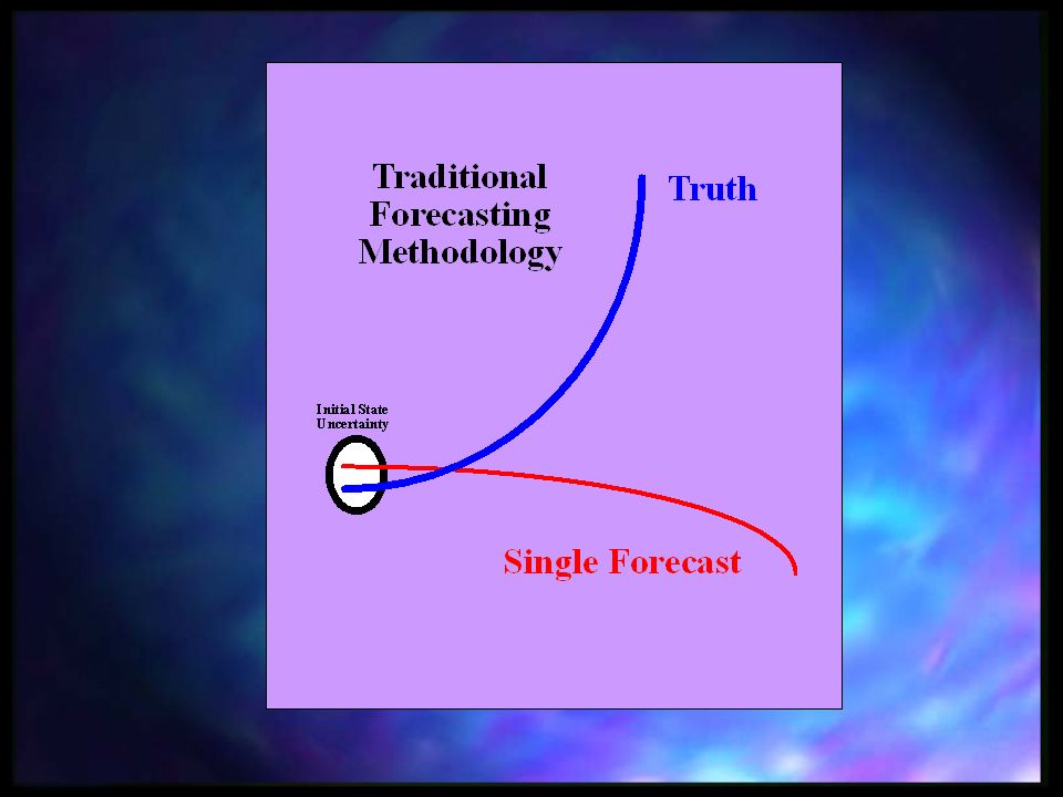
The Prediction Process Analyze Results Compare and Verify Observe the Atmosphere Identify and Apply Physical Laws Create a Mathematical Model Create and Run a Computer Model

8
Data Assimilation Data Assimilation System Radars Radial Wind, Reflectivity Other Observations A Bit of Everything Some Places Forecast Model Output All Variables, But From a Forecast 3D Gridded Analysis That Contains all Variables, is Dynamically Consistent, and has Minimum Global Error w/r/t the Observations

9
The First Numerical Weather Prediction Experiment n Done on ENIAC: 5 million times slower than my laptop n Numerically integrated one equation at one altitude n 450 mile grid spacing n 24 hour forecast took 24 hours

10
Today’s Models

11
Typical Forecast from Today’s Operational Models

12
What Causes the Major Problems?

13
A Foundational Question... explicitly predict this type of weather? Can computer forecast technology...

14
Example : March 28, 2000 Fort Worth Tornadic Storms

15
Tornado Local TV Station Radar

16
NWS 12-hr Computer Forecast Valid at 6 pm CDT (near tornado time) No Explicit Evidence of Precipitation in North Texas
 No Explicit Evidence of Precipitation in North Texas")
17
Reality Was Quite Different!

18
6 pm 7 pm8 pm Radar Xue et al. (2003) Fort Worth Hourly Radar Observations (Fort Worth Shown by the Pink Star)
 Fort Worth Hourly Radar Observations (Fort Worth Shown by the Pink Star).")
19
6 pm 7 pm8 pm Radar Fcst With Radar Data 2 hr 3 hr 4 hr Fort Worth Xue et al. (2003)
")
20
How Good Are the Forecasts?? Actual Event 30 miles D/FW Airport A perfectly predicted storm having a position error of 30 miles may be a terrible forecast on the scale of a single airport Forecast

21
O F 50 km One Forecast Verification Strategy HIT O F 50 km MISS

22
O F 30 km HIT O F MISS 30 km One Forecast Verification Strategy

23
Probability of Detection

24
False Alarm Rate

25
Actual Event 30 miles D/FW Airport We need to forecast the weather PLUS the accuracy of the forecast!!! Forecast

26
As a Forecaster Worried About This Reality… 7 pm

27
As a Forecaster Worried About This Reality… How Much Trust Would You Place in This Model Forecast? 3 hr 7 pm

30
Actual Radar

31
Forecast #1 Forecast #2 Forecast #3 Forecast #5 Forecast #4 Actual Radar

32
Probability of Intense Precipitation Model Forecast Radar Observations

33
MUCH MORE Computing Power is Required!!

36
n Each set of forecasts (ensemble and individual) –produces 6 TB of output PER DAY –Requires 9000 cores (750 nodes) of the Kraken Cray XT5 at Oak Ridge –Takes 6.5 hours to run n Provisioning of data in real time n Management in a repository – retention time? n Experiment reproducibility!! n Creating products that will benefit the public (smart device location-based warnings) Challenges
 Challenges.")
37
A Fundamental Research Question A Fundamental Research Question n Can we better understand the atmosphere, educate more effectively about it, and forecast more accurately if we adapt our technologies and approaches to the weather as it occurs? n People, even animals adapt/respond: Why don’t our resources???

38
The Vision Revolutionize the ability of scientists, students, and operational practitioners to observe, analyze, predict, understand, and respond to intense local weather by interacting with it dynamically and adaptively in real time

39
The Value of Adaptation: Forecaster- Initiated Predictions Brewster et al. (2008) Observed Composite Reflectivity 20 hr Pre-Scheduled WRF-ARF 5 hr LEAD Dynamic WRF-ARF With Radar Data Assimilation
 Observed Composite Reflectivity 20 hr Pre-Scheduled WRF-ARF 5 hr LEAD Dynamic WRF-ARF With Radar Data Assimilation.")
40
The Million Dollar Question: Will Computer Models Ever Be Able to Predict Tornadoes?

42
24 May 2011 Tornado Outbreak: Warning on a Numerical Forecast NWS OUN Graphic

43
24 May 2011 Tornado Outbreak: Warning on a Numerical Forecast

44
Are All the Data Making a Difference? 44

45
45 Are All the Data Making a Difference?

46
Numerical Simulation 24 hours CPU = 1 hour real 20 TB of output Still trying to understand Mother Nature Real time! Still trying to understand Data Don’t Guarantee Understanding!

48
n Be careful what you wish for! A one-hour model- based “tornado warning” would be a game changer n Social and behavioral science elements are critical –Why did 550 people die in the US last year from tornadoes? n Our ability to effectively warn the public and understand its response is relatively crude n This is an area ripe for additional research – and it is ESSENTIAL for making progress Challenges

49
TODAY: Centralized Prediction, Distributed Data

50
TOMORROW: Distributed & Cloud-Based Models Run Locally, On Demand 10 km 3 km 10 km 20 km CONUS Ensembles

Similar presentations


 is responsible for forecasts several times.>")
: Web Services for Meteorological Research and Education.>")


 National Oceanic and Atmospheric.>")
