Download presentation
Presentation is loading. Please wait.

1
The Glacial Features of Martha’s Vineyard - Part One

2
Questions to answer: How did the ice and water from the glacier form the Vineyard? Why is the Vineyard shaped like it is? Why are some areas hilly and other areas so flat? Why are some parts sandy and other areas full of rocks and boulders? How did the freshwater ponds and the saltwater ponds form? When did the Vineyard first form, and how has it changed since then?

3
Think about the variety in our landscape. That is why the Island is so beautiful.

4
For a small island, it is very diverse. And perhaps that is why the Island is so popular.

5
So how did it get that way? And what did the Pleistocene Ice Age have to do with it?

6
KEEP IN MIND: Huge continental glaciers can reshape the land beneath them and in front of them, completing scraping away the land, while carving new landscapes. And they can carry this material (soil, rocks, etc...) for hundreds of miles, depositing it into a variety of new landscapes.
 for hundreds of miles, depositing it into a variety of new landscapes..")
7
LET’S GO BACK IN TIME: Imagine being on the Earth about 18,000 years ago, at peak glaciation of the Wisconsinan Stage of the Pleistocene Ice Age. What would it be like? What would it look like?

8
Probably something like this (Greenland today).
.")
9
And this (also on Greenland).
.")
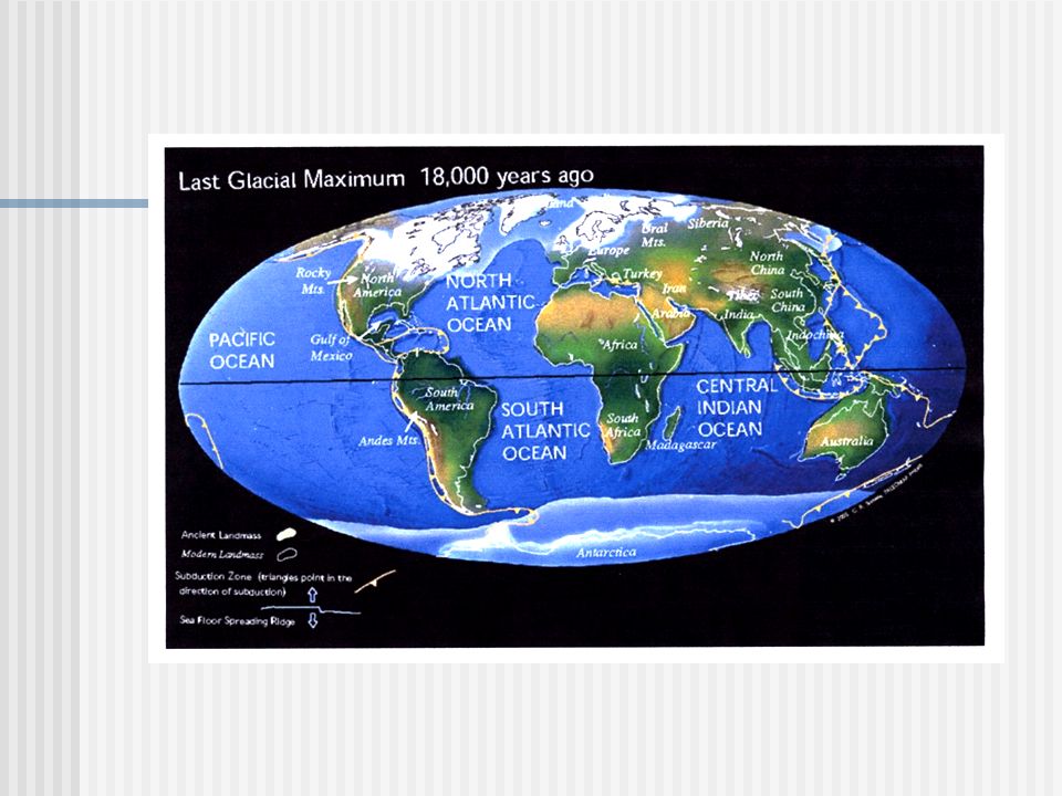
12
Here is what a map of North America would have looked like then.

13
The Ice Sheets It is important to remember that the great ice sheets - even at their largest and not growing bigger - actually “flowed”. Glacial ice flows very slowly, but it can sometimes surge rapidly. As glacial ice “flows”, it scrapes and plucks and deposits and reshapes the land underneath it, and even ahead of it. The direction of the flow is important to note.

14
There were actually three main ice sheets in North America. Notice the direction of the ice flow. Why is the direction always away from the center of the ice sheets?

15
Glacial “till” Term for anything carried by glaciers. Rocks, gravel, sand, silt, clay. Our till was carried from places as far away as New Hampshire, Vermont, even Canada. Also called glacial “drift”. Glaciers, even smaller mountain glaciers, can carry hundreds or thousands of CUBIC MILES of till.

16
Glacial ice can be loaded with till.

17
Now imagine flying over what will someday be called New England, including Martha’s Vineyard. Remember what happened to sea level. Look where the coast was then!

18
This is what it probably looked like then. (This shot is from Greenland today.)
")
19
The Edge of the Ice Actually made of many “lobes” of ice. Ice was loaded with till. Till especially built up along edges of the ice because of the ice flow. Tremendous winds blowing off the ice. Glacial meltwater runs from the edge as ice is constantly melting, often forming streams that criss- cross. The land just beyond the edge is frigid cold, barren, harsh (tundra-like conditions). We see these conditions in Greenland today.
. We see these conditions in Greenland today..")
20
The top of a glacial ice sheet. (This shot is also from Greenland.)
")
21
There were three main lobes of ice that contributed to forming Cape Cod and the Islands.

22
Notice the direction of the ice flow. Notice the shape of the ice lobes, and the shape of the Cape and Islands. Notice where the ice stopped (twice). Is this a coincidence?
. Is this a coincidence .")
23
Summary: The Pleistocene Ice Age reshaped much of North America forever. The Pleistocene Ice Age is also responsible for the formation of the Cape and Islands Both glacial ice and glacial meltwater can change the landscape, but in different ways. Till is any material carried by glacial ice. Glacial ice flows very slowly as it grows. We can tell the direction of the flow today. Glacial ice can also melt back, leaving deposits. The edges of these huge ice sheets were especially full of till. The edges also are where the meltwater occurred mostly. We can go to Greenland today to study the best example of how a huge continental glacier looks and behaves.

Similar presentations