Download presentation
Presentation is loading. Please wait.

1
e-Government Projects in Greece Developed in a Research Environment Poulicos Prastacos Director of Research Institute of Applied and Computational Mathematics Foundation for Research and Technology-Hellas Hrakleion, Greece Poulicos@iacm.forth.gr

2
Outline of presentation E-Government and Research Institutions Health map of Greece Environmental management – noise mapping Development of a portal for the coastal area Dissemination of traffic information in real time Conclusions

3
e-Government with spatial components Spatial planning –Environmental planning –Urban planning –Transportation Planning –……. Provision of services to citizens –Dissemination various spatial information to the citizens

4
Why research institutions get involved Technologically advanced countries –Projects initiated by the government –Carried out by the private sector Countries in which technology is not the dominant sector –Projects are initiated as pilot projects by Research/ Academic institutions –Often developed with minimal input by the Government –After some years government initiates the project again on a full scale –Private companies implement it

5
FORTH Second Largest Research center in Greece, located in Crete 7 Institutes, about 200 Researchers Budget 40% from Government, rest from competitive projects (EU, national etc.) Regional Analysis Division, Institute of Applied Mathematics –Involved with the development of tools and methodologies related to spatial planning –GIS technology –Involved in numerous e-government type of projects in Greece and elsewhere
 Regional Analysis Division, Institute of Applied Mathematics –Involved with the development of tools and methodologies related to spatial planning –GIS technology –Involved in numerous e-government type of projects in Greece and elsewhere")
6
Health map of Greece A GIS based tool developed under a grant from the Greek Ministry of Health that allows the mapping of: –The position of all public health resources and infrastructure –The spatial component of Public Health –The supply and demand of medical services at the local level Developed for the Regional Health Authorities Operational project, not pilot application

7
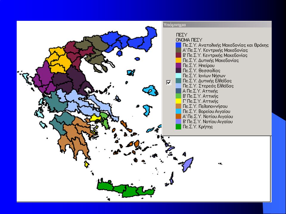
Developed for the Regional Health Authorities Greece is divided into 17 regions each supervised by a Regional Health Authority (PESY) established by the Ministry of Health Each PESY are responsible for administration, management and strategic planning of Public Health resources at the regional level Each PESY needs a tool to: –Inventory all Public Health Resources under administration –Evaluate the Public Health providers and the quality of their services in each region –Aid the decision making for long-term planning and future investment
 established by the Ministry of Health Each PESY are responsible for administration, management and strategic planning of Public Health resources at the regional level Each PESY needs a tool to: –Inventory all Public Health Resources under administration –Evaluate the Public Health providers and the quality of their services in each region –Aid the decision making for long-term planning and future investment")
9
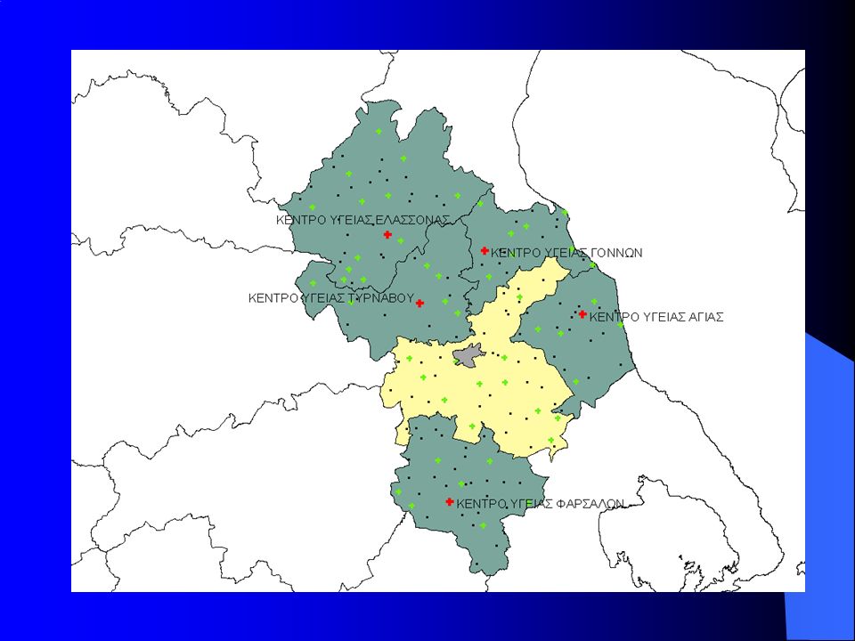
Data included in the system Data for health facilities: –General Hospitals (118) –Medical Centers (199) –Hospitals – Medical Centers (combined) (17) –Village Clinics (1538) Population and epidemiology data at the prefecture level Geographical layers –Settlements –Road network –Communes –Municipalities –Prefectures –Regions
 –Medical Centers (199) –Hospitals – Medical Centers (combined) (17) –Village Clinics (1538) Population and epidemiology data at the prefecture level Geographical layers –Settlements –Road network –Communes –Municipalities –Prefectures –Regions")
10
Data attributes for health facilities Address, contact information Number of clinics, ambulances Personnel : –Doctors by specialty –Nurses by specialty –Other personnel (administrative, technical support etc) Medical clinics (Hospitals) Outpatient clinics and hours of operation Laboratories and number of medical tests and examinations Bio-medical equipment Preventive health care services Other operational characteristics
 Medical clinics (Hospitals) Outpatient clinics and hours of operation Laboratories and number of medical tests and examinations Bio-medical equipment Preventive health care services Other operational characteristics")
12
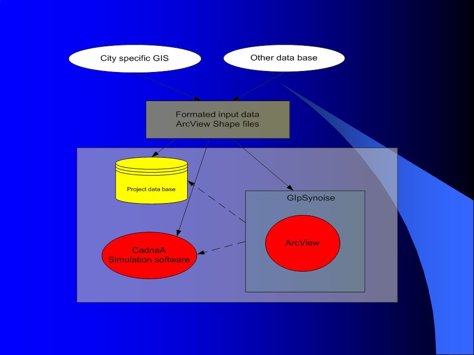
Overall architecture of the system

13
How does the system could be used to assist decision making Extensive search capabilities –Geographical criteria –Operational characteristics of the health facilities –Availability of resources –Utilization of medical facilities Development of indices and production of thematic maps

14
Health Indices Various population and epidemiology indices calculated at different geographical levels/facilities for example: –Births –Mortality from all types of cancers –Deaths from circulatory illnesses –Serious injuries caused by traffic accidents –Doctor specialties (Medical Center Microbiologists per 1000 inhabitants living in the coverage area) –Nurse specialties –Outpatient clinics by specialty (visits per 1000 inhabitants) –Laboratory exams (Microbiology tests per 1000 inhabitants) –Hospital beds per 10 thousand inhabitants –Surgical Hospital beds per 10 thousand inhabitants –Doctor specialties (Radiologists per 10 thousand inhabitants) –CT scanners per 10 thousand inhabitants
 –Nurse specialties –Outpatient clinics by specialty (visits per 1000 inhabitants) –Laboratory exams (Microbiology tests per 1000 inhabitants) –Hospital beds per 10 thousand inhabitants –Surgical Hospital beds per 10 thousand inhabitants –Doctor specialties (Radiologists per 10 thousand inhabitants) –CT scanners per 10 thousand inhabitants")
15
Hospital radiologists / 10 inhabitants

16
Health facilities on the web Web site developed as part of the same project that included data on all facilities and resources Users could query the web site to find out: –Location of closest public health facility –Hours of operation –Medical specialties available –How to get there

17
Evaluation of the project Project initiated by the Minister of Health Project completed successfully Extensive training provided Used for one year Then abandoned for the following reasons –Data were not being updated –Funding was not available –There was discussion for a “bigger” project that would feed electronically all the information to the various databases. However, this was never materialized

18
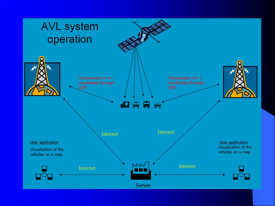
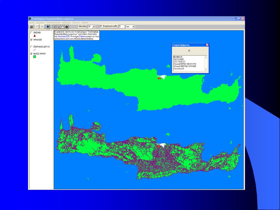
AVL system for Health Emergency Services in Crete Each ambulance equipped with a GPS and GSM modem Position transmitted at the Center and displayed on a map At the Center dispatcher can reroute ambulances etc. according to the needs that arise

21
Evaluation of the project Initiated in 1997 as part of a research project Not fully functional because of problems with communication technology Fully developed and functioning since 2003 with the assistance of IT companies “associated” with FORTH

22
SDI-Development of a Portal for Coastal Zone management Project started recently Funded by the Secretarial for Research and Technology Collaboration of FORTH with IT companies and public authorities

23
Objectives Develop distributed databases storing and managing data and information related to the coastal zone Procedures for extracting data from satellite pictures and from on the field capture of data through GPS Procedures for analyzing the various thematic information for estimating complex environmental indicators A Geo-portal capable of distributing the data and the resulting information to several administration levels Objective is to start the development of an SDI for the Region of Crete

24
Environmental modeling noise mapping DAMEN directive issued by the EU in 2002 All cities with population larger than 250,000 pop should develop noise maps by 2007 Need for a tool to assist decision makers to evaluate noise reduction plans GipsyNoise Project funded by LIFE Tool developed by FORTH tested in several European cities

25
GipsyNoise GIS based tool for estimating noise levels from traffic, railroad, industry Combines GIS and noise dispersion tools Extensive visualization and reports capability All results in terms of harmonized indicators Capability to perform scenarios

27
Comparison of results from different scenarios Introduce policies reducing traffic in some cities Initial condition Scenario Difference

28
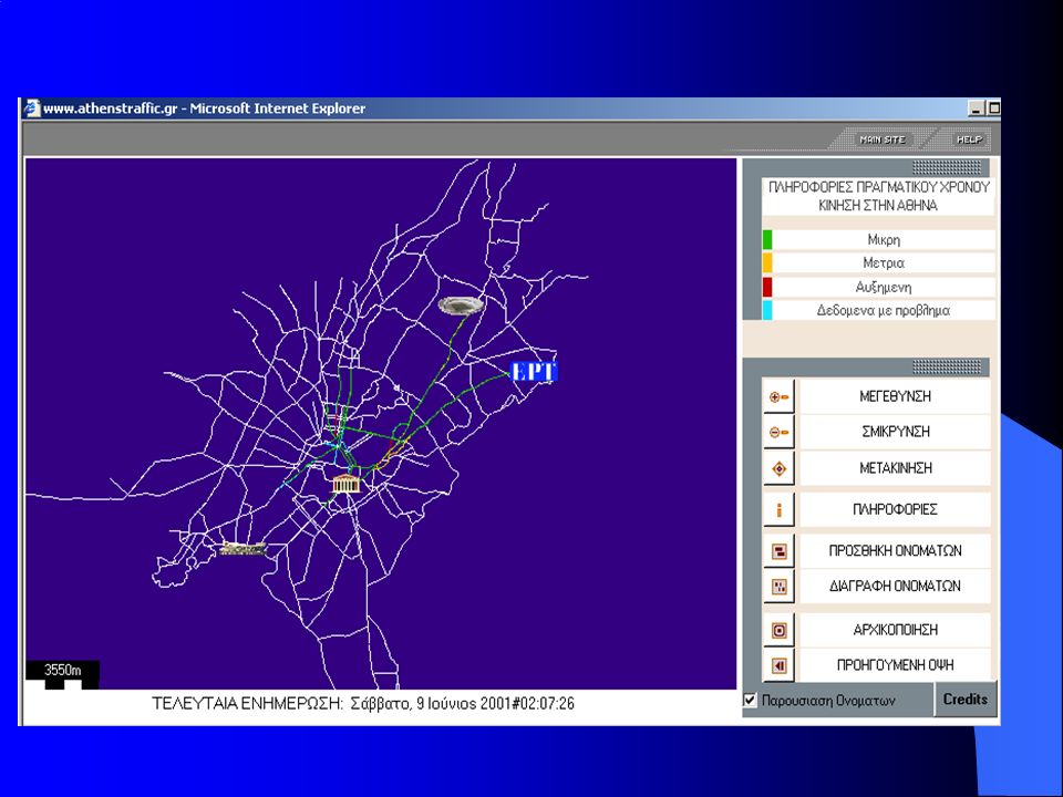
Displaying information for traffic on the net Ministry of the Environment collects data from loop detectors Issue is how to disseminate these to concerned citizens in real time Project funded by Ministry, implemented by FORTH and two “affiliated” IT companies Special Java applet developed

30
Conclusions In Greece, many e-government projects have started in a research environment The big issue is how to continue the project once the funding for the pilot applications has finished Often the projects “discarded” and “reinvented” after some years. Pilot projects play the role of educating the public sector on the need for e government

Similar presentations


-BANGLADESH MOHFW is responsible to ensure basic health care to the people.>")


, Namibia By Mrs Ottilie M Mwazi Chief Statistician, Survey, Cartography/GIS>")


 School of Chemical Engineering Unit of Environmental Science and Technology (UEST) Katherine Haralambous.>")
 for Khorasan Province in Iran (Technical Report) S.H. Sanaei-Nejad, (MSc, PhD) Ferdowsi University.>")