Download presentation
Presentation is loading. Please wait.

1
Oceans and Coastlines

2
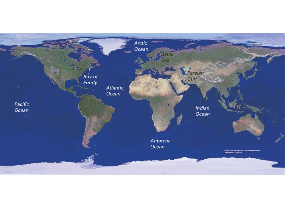
Ocean Basins Oceans are all connected, so it’s really just 1 big ocean! 5 ocean basins –Atlantic –Pacific –Indian –Antarctic (Southern) –Arctic (northern extension of the Atlantic)
 –Arctic (northern extension of the Atlantic).")
4
Fig. 15.7a, p.380

5
Seawater Composition and Salinity –The salt content or salinity is around 3.5% –The dissolved material in sea water comes from Weathering of rock and transport to sea by rivers Volcanic activity –Evaporation and freezing tend to concentrate salt in sea water –Salt is removed by biological organisms –Sea water also receives an influx of fresh water from precipitation and river flow

6
3 Major Density Zones in the Ocean (controlled by temperature and salinity)
")
7
Current: continuous flow of water in a given direction Surface currents: caused by winds Winds blow in preferred directions due to differential heating of the earth’s surface Example of a surface current: Gulf Stream – 80km wide by 650m deep, 5km velocity (at fastest)
")
8
Gyres - circuit of currents around the periphery of an ocean basin Gulf Stream Current is part of the North Atlantic Gyre) Caused by Westerlies and trade winds Trade winds blow from the northeast in the or southeast in the tropics Westerly winds (westerlies) blow from the northwest or southwest in the mid- latitudes
 Caused by Westerlies and trade winds Trade winds blow from the northeast in the or southeast in the tropics Westerly winds (westerlies) blow from the northwest or southwest in the mid- latitudes")
9
Gyres

10
Gyres circulate clockwise in the northern hemisphere Gyres circulate counterclockwise in the southern hemisphere

11
Surface Ocean Currents Currents on the west side of the ocean basin (i.e. east side of continent) originate in the tropics and are warm-water currents Examples: Gulfstream, Brazil Current Currents on the east side of the ocean basin (i.e. west side of continent) originate at the poles and are cold-water currents Examples: California Current, Humbolt Current (cause of El Nino)
 originate in the tropics and are warm-water currents Examples: Gulfstream, Brazil Current Currents on the east side of the ocean basin (i.e. west side of continent) originate at the poles and are cold-water currents Examples: California Current, Humbolt Current (cause of El Nino).")
12
Surface Ocean Currents

13
The diagram shows the South Pacific during a normal year. Strong S. Pacific Equatorial Current reinforces the northward-flowing Humbolt Current This promotes upwelling of cold, nutrient-rich water, which supports the S. American fishing industry

14
An El Nino Event (ENSO) –Occurs every 3-7 years for a year –Weakens trade winds and S. Pacific Equatorial current –This in turn weakens the Humbolt Curent which reduces cold upwelling –This creates warmer surface water, depresses the fishing industry and changes weather patterns in many places.

15
Consequences of El Nino Anomalous warm water off the coast of South America Increased storm activity in many parts of the U.S and northwestern Europe Drought in Australia and S.E. Asia

16
Deep-Ocean Currents- Thermohaline Circulation –caused by density differentials –Temperature: cold water is more dense than warm and will sink –Salinity: saltier water is denser than fresh water and will sink –Deep-ocean currents are connected to the surface current system –Increased freshening of polar waters is changing thermohaline circulation patterns. What is the effect on surface currents?

17
If the Labrador Current (Cold) is too fresh to sink, it may block passage of the N. Atlantic Drift (warm) which moderates the climate of Great Britain and Scandinavia
 which moderates the climate of Great Britain and Scandinavia.")
18
Global warming and sea-level rise Sea-level has risen and fallen in the past –Past 40,000 yrs, 150m fluctuation –More recently, sea-level is rising ~3mm/yr –Warming temperatures raise sea level by Thermal expansion of water Release of glacial water that was on land –Some low lying coasts and islands are already feeling effects

19
Fig. 16-39, p.401

20
Rising Sea Level

21
Fig. 16.38a, p.423

22
Tides Both the Earth and the Moon revolve around a point located in the interior of the earth, near point A. The solid Earth is not affected, but the water forms 2 permanent bulges.

23
Tides Bulge “A” caused directly by gravitational attraction of moon. Bulge “B” caused by inertia of water as earth swings inward toward the moon (“centrifugal force”).
..")
24
Tides As the earth rotates, shorelines pass through each bulge approximately 12 hours apart. Other influences include: –Gravitational effect of the Sun –Shape of the coastline

25
Spring and Neap Tides Spring tide – highest tides, occur when Earth, Sun & Moon are in alignment Neap tide – lower high tide, when Earth, Sun & Moon form a 90 o angle

26
Spring and Neap Tide

27
Beach Drifting and Longshore Currents

28
Fig. 16-22, p.390

Similar presentations


>")


>")


