Download presentation
Presentation is loading. Please wait.

1
CBERS Program: An Overview Earth Observation Directorate September 2004 Prepared by José Carlos Epiphanio (CBERS Application Program Manager) and Gilberto Câmara (Director for Earth Observation)
 and Gilberto Câmara (Director for Earth Observation)")
2
CBERS: China-Brazil Earth Resources Satellite Brief History Initial agreement signed in July 6th, 1988, covering CBERS-1 and 2. In 2002, both governments decided to expand the initial agreement by including CBERS-3 and 4. Program objectives Build a family of remote sensing satellites to support the needs of users in earth resources applications Improve the industrial capabilities of space technology in Brazil and China

3
CBERS Program Timeline Launch Date Operation20042005200620072008200920102011 CBERS-119994 years CBERS-220034 years CBERS-2B20064 years CBERS-320085 years CBERS-420115 years

4
CBERS Satellite Platform Total Weight: 1500 Kg Dimension: 1,8 x 2,0 x 2,2 m Power: 1100W AOCS:3 axis stabilization Compatible with Long March-4 launch vehicle. Payload bit rate: 53 Mb/sec x 2 (CBERS-1,2) 150 Mb/sec x 2 (CBERS-3,4) Design already qualified in CBERS-1 and 2, will be improved for CBERS-2B, 3 and 4
 150 Mb/sec x 2 (CBERS-3,4) Design already qualified in CBERS-1 and 2, will be improved for CBERS-2B, 3 and 4.")
5
CBERS Orbit Sun synchronous Height: 778 km Inclination: 98,48 degrees Period: 100,26 min Equator crossing time: 10:30 AM Revisit: 26 days Distance between adjacent tracks: 107 km

6
CBERS-2

7
Work Share (70% China, 30% Brazil) Service Module StructureBrasil Thermal Control China Attitude and Orbit Control China Power supplyBrasil On-board computerChina TelemetryBrasil Payload Module CCDChina IRMSSChina WFIBrasil Data TransmissionChina Data collectionBrasil
 Service Module StructureBrasil Thermal Control China Attitude and Orbit Control China Power supplyBrasil On-board computerChina TelemetryBrasil Payload Module CCDChina IRMSSChina WFIBrasil Data TransmissionChina Data collectionBrasil")
8
CBERS-2 being put into Long March-4B

9
Long March-4B Height: 44 meters 3 stages, liquid fuel Capacity of launching 2800 kg in sun-synchronous orbit (900km) Total weight: 250 tons (232 tons of fuel) Launched 6 times with success since May 1999
 Total weight: 250 tons (232 tons of fuel) Launched 6 times with success since May 1999")
10
CBERS-2 Launch (21 October 2003 ) CBERS-2
 CBERS-2")
11
CBERS-2 Orbits

12
CBERS 1,2, 2B Sensor Configuration mm 0.42.50.71.10.90.51.51.7 2.3 WFI 260 m (890 km) MSS 80 m (120 km) CCD 20 m (120 km) Built by ChinaBuilt by Brazil
 MSS 80 m (120 km) CCD 20 m (120 km) Built by ChinaBuilt by Brazil")
13
CBERS-1,2, 2B Sensor Configuration Sensor Bands ( m) Swath (km)Resolution (m) CCD0.45-0.5212020 0.52–0.5912020 0.63–0.6912020 0.77–0.8912020 0.51-0.7312020 IRMSS0.76-1.1012080 1.55–1.7512080 2.08–2.3512080 10.4–12.5120160 WFI0.63–0.69890260 0.77–0.89890260
 Swath (km)Resolution (m) CCD – – – IRMSS – – – WFI0.63– –")
14
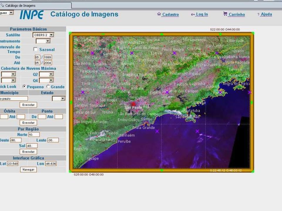
Image CBERS-2 WFI CBERS2-WFI – 157/124, 18/01/2004, São Paulo WFI sensor

15
CBERS2-WFI – 157/124, 10/03/2004, São Paulo WFI sensor

16
CB2-IRM-157/123, 18/01/2004 10/03/2004 CB2-CCD CBERS-2 IRMSS (Rio Preto, Brazil)
")
17
CB2-IRM-157/124, 24/3/2004, Catanduva (Brazil) IRMSS sensor
 IRMSS sensor")
18
CBERS2 - IRMSS x CCD (Maringá, Brazil) CB2-IRM-159/126, 30-03-2004CB2-CCD-159/126, 30-03-2004
 CB2-IRM-159/126, CB2-CCD-159/126,")
19
CBERS-2 CCD, Minas Gerais, Brazil

20
CB2 – CCD 156/121- 4/11/2003 – Brazil

21
CBERS-2 CCD Sobradinho Dam, Brazil Dez 2003

22
CBERS-2 CCD, Parnaíba River Delta, Nov 2003

23
CBERS-2 CCD Manaus, Brazil, Dec 2003

24
CBERS-2 CCD, Pradópolis, Brazil, Nov 2003

25
CBERS 3 – 4 Sensor Configuration mm 0.42.30.71.10.90.51.51.7 2.1 WFI 73 m (860 km) MSS 40 m (120 km) CCD 20 m (120 km) MUX 10 m (60 km) PAN 5 m (60 km) Built by ChinaBuilt by Brazil
 MSS 40 m (120 km) CCD 20 m (120 km) MUX 10 m (60 km) PAN 5 m (60 km) Built by ChinaBuilt by Brazil")
26
Launch Date Res (m) 2004200520062007200820092010 LANDSAT5198430 LANDSAT82008?25 HRV/SPOT4199810/20 HRV/SPOT5200220 CCD CBERS-2 200320 CCD CBERS-2B 200620 CCD CBERS-3 200720 LISS-3 IRS-P6 200323 Optical Sensors (Medium Resolution, Global Coverage)
 LANDSAT LANDSAT HRV/SPOT /20 HRV/SPOT CCD CBERS CCD CBERS-2B CCD CBERS LISS-3 IRS-P Optical Sensors (Medium Resolution, Global Coverage)")
27
Swath (km) Res (m) 2004200520062007200820092010 MODIS (TERRA AQUA) 25002502001 VEGETATION (SPOT-4/5) 250010002003 MERIS (ENVISAT) 11003002002 WFI (CBERS2 CBERS2B) 8902602003 AWFIS (IRS)700652003 AWFI (CBERS-3)750702008 Optical Sensors (Large Swath, High Temporal Resolution)
 Res (m) MODIS (TERRA AQUA) VEGETATION (SPOT-4/5) MERIS (ENVISAT) WFI (CBERS2 CBERS2B) AWFIS (IRS) AWFI (CBERS-3) Optical Sensors (Large Swath, High Temporal Resolution)")
28
CBERS 3/4 x LANDSAT-8 mm 0.42.30.71.10.90.51.51.7 2.1 CCD 20 m (120 km) MUX 10 m (60 km) PAN 5 m (60 km) PAN 15 m (180 km) TM 30 m (180 km) MSS 40 m (120 km) WFI 73 m (860 km)
 MUX 10 m (60 km) PAN 5 m (60 km) PAN 15 m (180 km) TM 30 m (180 km) MSS 40 m (120 km) WFI 73 m (860 km)")
29
CBERS 3/4 x IRS-P6 e IRS-P5 mm 0.42.30.71.10.90.51.51.7 2.1 CCD 20 m (120 km) MUX 10 m (60 km) PAN 5 m (60 km) PAN 2.5 m (30 km - stereo) LISS 23 m (140 km) MSS 40 m (120 km) WFI 73 m (860 km) MSS 5.8 m (24 km) AWFIS 70 m (700 km)
 MUX 10 m (60 km) PAN 5 m (60 km) PAN 2.5 m (30 km - stereo) LISS 23 m (140 km) MSS 40 m (120 km) WFI 73 m (860 km) MSS 5.8 m (24 km) AWFIS 70 m (700 km)")
30
CBERS Ground Station Reception & Recording System Quality Control System Product Generation System Catalogue Browse System Order Management System Acquisition Planning System

31
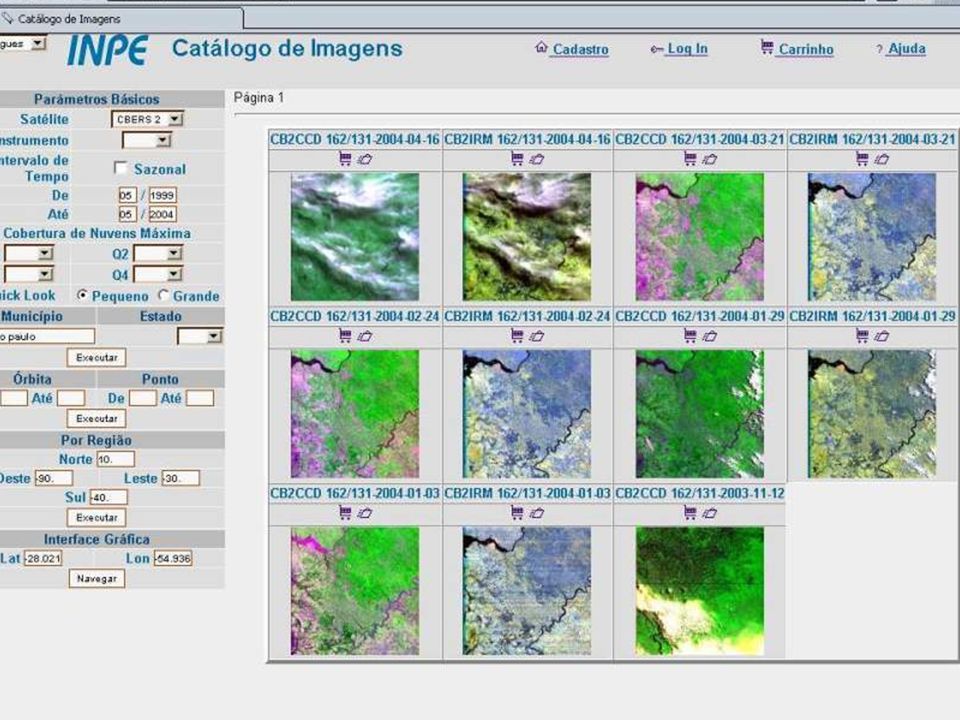
CBERS Ground Station in Brazil Developed by Brazilian company and INPE Major cost saving User-centered design User requests products in a web interface Products are generated automatically User can download products via FTP Efficiency and scalability Based on low-cost Linux PCs Totally automated, no operator intervention

32
Ground Station Design Principles Low-cost hardware Standard PCs Open software and standards Linux, GCC, Apache, PHP, MySQL, HDF, GeoTIFF, XML Scalability and automation Modules, distributed processing Use of Internet technology Scripting languages, Web browser

33
CBERS Image Distribution in Brazil (May to August 2004) Total number of full CCD scenes distributed (145 Gb/scene) 22,460 Number of users4960 Number of scenes produced per week2115 Average time to process a user request12 min Production environment8 PCs/Linux
 Total number of full CCD scenes distributed (145 Gb/scene) 22,460 Number of users4960 Number of scenes produced per week2115 Average time to process a user request12 min Production environment8 PCs/Linux")
38
FTP area for User

39
Data Policy for CBERS Three different situation Case 1: Distribution of data received at China and Brazil Case 2: Use of on-board data recorder Case 3: Data reception and distribution by other ground stations

40
Case 1 Imagens received by Brazil/China ground stations These ground stations have unlimited access to all data collected within their footprint. The policy for distribution of data collected by those ground stations will be decided by each operator. CRESDA can distribute all data collected by the Urumqi, Guangzhou and Beijing ground stations according to its best interests INPE can distribute all data collected by the Cuiaba ground station according to its best interests

41
CASE 2 - Images obtained by OBDR INPE and CRESDA have exclusive rights for use of on- board data recorder for CBERS-2 and CBERS-2B

42
CASE 3 – Distribution of Images Outside Brazil/China CRESDA and INPE will license a third party company that will sell access time to CBERS for international ground stations CBERS is marketed as a LANDSAT-class satelite Access fee covers full downlink to data on ground station footprint Software and hardware for CBERS ground stations is provided by a company licensed by INPE and CRESDA

Similar presentations


, infrared (BW, Color) –RADAR (SLAR, SAR) –LIDAR (light detection and ranging)>")


 INPE PoC for CEOS 1 23 rd CEOS Plenary I Phuket, Thailand.>")


 A demonstration space mission dedicated to land surface environment (Vegetation and Environment New.>")


