Download presentation
Presentation is loading. Please wait.

1
Chapter 4 Integrating Site Design and Stormwater Management Frank X. Browne, Ph.D., P.E. F. X. Browne, Inc. www.fxbrowne.com

2
Presentation Overview of Low Impact Development Concepts Overview of Low Impact Development Concepts Discussion of Chapter 4 Discussion of Chapter 4 Case Studies Case Studies

3
Low Impact Development An innovative, ecosystem- based approach to land development and stormwater management

4
Why We Need Low Impact Development Protect and Improve Protect and Improve Water Quality Water Quality Watershed Hydrology Watershed Hydrology Fish and Wildlife Fish and Wildlife Reduce Infrastructure Costs Reduce Infrastructure Costs Make Communities More Attractive Make Communities More Attractive

5
Low Impact Development Mimic Predevelopment Site Hydrology Using Site Design Techniques that Store, Infiltrate, Evaporate and Detain Stormwater Runoff

6
The difficulty lies not in the new ideas, but in escaping from the old ones. John Maynard Keynes, 1936

7
Conventional

8
Low Impact Development Objectives Reduce Effective Impervious Area Reduce Effective Impervious Area Infiltrate Stormwater Infiltrate Stormwater Maximize Evapotranspiration Maximize Evapotranspiration

9
Low Impact Development Planning Concepts A. Maintain/Improve Site Hydrology B. Think Small C. Control Stormwater at the Source D. Use Natural, Nonstructural Methods E. Create Multifunctional Environment Modified from Prince George County, Maryland

12
Chapter 4 Integrating Site Design and Stormwater Management

14
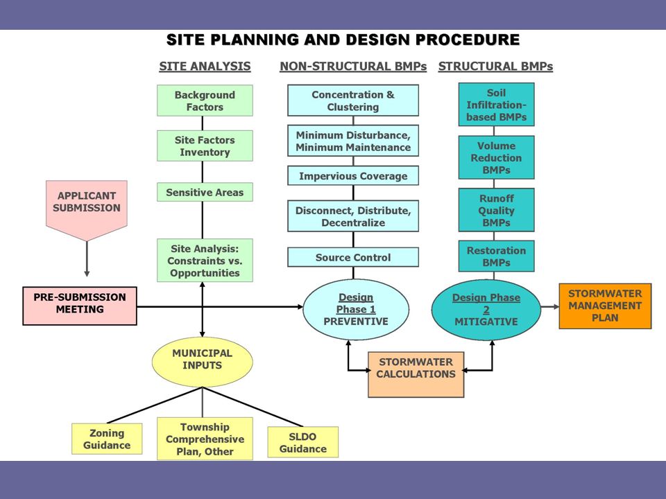
SITE ANALYSIS Background Site Factors Site Factors Inventory Site Factors Analysis

15
Background Site Factors Describe hydrologic context and other natural elements Chapter 93 stream use designation Special Protection Waters (EV, HQ) Fishery/Aquatic Life Use (WWF, CWF, TSF) Chapter 303d/impaired streams Aquatic biota sampling Sensitive downstream areas (water supply source) Location of any know downstream flooding Any Special Areas?
 Fishery/Aquatic Life Use (WWF, CWF, TSF) Chapter 303d/impaired streams Aquatic biota sampling Sensitive downstream areas (water supply source) Location of any know downstream flooding Any Special Areas")
16
Special Areas Previously Mined AMD/AML areas Brownfields Source Water Protection areas Urban Areas Carbonate/Limestone Other

17
Site Factors Inventory Describe the existing developed features of the site, if any Describe important natural features of site

18
Describe the size and shape of the site Special constraints/opportunities Special site border conditions and adjacent uses

19
Describe the existing developed features of the site, if any Existing structures/structures to be preserved Existing cover/uses Existing impervious areas Existing public sewer and water Existing storm drainage systems Existing on-site water and wastewater

20
Describe important natural features of site Existing hydrology (drainage swales, intermittent, perennial) Existing topography, contours, subbasins Soils on site – potential for infiltration Areas of vegetation (trees, scrub, etc) Special Value Areas Sensitive Areas PNDI areas or species
 Existing topography, contours, subbasins Soils on site – potential for infiltration Areas of vegetation (trees, scrub, etc) Special Value Areas Sensitive Areas PNDI areas or species")
21
Special Value Areas Wetlands, hydric soils Floodplains/alluvial soils High quality woodlands, other woodlands and vegetation Riparian buffers Naturally vegetated swales/drainageways

22
Sensitive Areas Steep slopes Special geologic conditions (limestone) Shallow bedrock (less than 2ft) High water table (less than 2ft)
 Shallow bedrock (less than 2ft) High water table (less than 2ft)")
23
Site Factors Analysis Characterize site constraints Wetlands Bog turtle habitat Streams and ponds Characterize site opportunities\ Good soils Woodlands Riparian buffers

24
Constraints and Opportunities Avoid development on or near special and sensitive natural features Place impervious areas on poor soils Protect good soils – use for infiltration

25
Using the site opportunities Has a Potential Development Area been defined? Does the proposed layout fit the constraints and opportunities of the site?

27
MUNICIPAL INPUTS Township Comprehensive Plan and Zoning guidance Township SLDO guidance and options Township SLDO/stormwater requirements Is useful interaction at sketch plan or even pre-sketch plan phases occurring?

28
Township Comprehensive Plan and Zoning guidance Guidance in Comprehensive Plan? Existing Zoning District? Total number of units allowed? Type of units? Density of units? Any allowable options?

29
Township SLDO guidance and options Performance standards for neo-traditional, village, hamlet planning? Reduce building setbacks? Curbs required? Street width, parking requirements, other impervious requirements? Cut requirements? Grading requirements? Landscaping requirements?

30
Township SLDO/stormwater requirements Peak rate and design storms Total runoff volume Water quality provisions Methodology requirements Maintenance requirements

32
SITE DESIGN: NON-STRUCTURAL BMPs Lot Concentration and Clustering Minimum Disturbance Impervious Coverage Reduction Disconnect/Distribute/Decentralize Source Control

33
Lot Concentration and Clustering Reduce individual lot size Concentrate/cluster lots Configure lots to incorporate natural site characteristics Orient structures to fit natural topography Minimize site disturbance

34
Minimum Disturbance Define disturbance zones for site Protect good soils Protect sensitive and special areas Minimize total site compaction Maximize zones of open space and greenways Consider re-forestation and re-vegetation opportunities

35
Impervious Coverage Reduction Reduce road widths and lengths Use Cul-de-sacs with vegetated islands Reduce driveway length and width Reduce parking ratios and sizes Evaluate shared parking Use porous surfaces where applicable Design single-side sidewalks

36
Disconnect/Distribute/Decentralize Rooftop disconnection Existing yard areas Existing vegetated areas/woods Disconnection from storm sewers/street gutters Front/side yard opportunities Vegetated swales, rain gardens, etc.

38
SITE DESIGN: STRUCTURAL BMPs Volume/Peak Rate Using Infiltration Volume/Peak Rate Reduction Using Other Methods Runoff Quality/Peak Rate Reduction Site Restoration Testing Protocols

39
Volume/Peak Rate Through Infiltration Porous Pavement with Infiltration Beds Infiltration Basins Infiltration Trenches Rain Garden/Bioretention Dry Wells/Seepage Pits Vegetated Swales Vegetated Filter Strips Infiltration Berm/Retentive Grading

40
Volume/Peak Rate Reduction – Other Methods Vegetated Rooftops (Green Roofs) Capture & Reuse Cisterns Rain Barrels
 Capture & Reuse Cisterns Rain Barrels")
41
Runoff Quality/Peak Rate Reduction Constructed wetland Wet pond/retention basin Dry extended detention basin (Naturalized Basin) Water quality filters: Constructed and Other Sand and sand/peat filters Multi-chamber catch basins and inlets
 Water quality filters: Constructed and Other Sand and sand/peat filters Multi-chamber catch basins and inlets")
42
Site Restoration for Stormwater Riparian Buffer Restoration Landscape Restoration Soil Amendment/Restoration Streambank Restoration

43
Testing Protocols Soil Testing Site Infiltration

44
STORMWATER METHODOLOGY AND CALCULATIONS Iterative Process Occurring Throughout Planning and Design to Maximize Non-Structural Practices Strive to Minimize Stormwater Runoff Strive to Achieve Standards of Comprehensive Stormwater Management

45
DEVELOP COMPREHENSIVE STORMWATER MANAGEMENT PLAN Has There Been Thorough Approach To Use of Both Non-Structural and Structural BMPs? If not, what non-structurals and structurals might be used? Should the building program be modified? What Related Benefits Are Being Achieved Through The Use of BMPs?

46
Case Study Stony Creek Farms Age Qualified Residential Development Homsher Hill, LLC Worcester Township, Pennsylvania

47
Proposed Development Age-Qualified Community Age-Qualified Community 209 Townhouses 209 Townhouses Clubhouse Clubhouse Day Spa Day Spa

48
Site Conditions Forested Forested C and D Soils C and D Soils Mild Slopes Mild Slopes Intermittent Stream Intermittent Stream Natural Stream Buffer Natural Stream Buffer

49
Goals Control 2-Year Storm Control 2-Year Storm Peak runoff rates Peak runoff rates Runoff volume Runoff volume Water quality Water quality Larger Storms Larger Storms Control peak runoff rates Control peak runoff rates

50
Objectives Reduce effective impervious area Reduce effective impervious area Maintain natural conditions Maintain natural conditions Treat at source Treat at source Minimize storm sewers Minimize storm sewers Infiltrate and evaporate stormwater Infiltrate and evaporate stormwater

51
Approach Identify Potential BMPs Identify Potential BMPsLocationsDepths Perform Soil Testing Perform Soil Testing Evaluate Soil Data & BMPs Evaluate Soil Data & BMPs Develop Conceptual Plan Develop Conceptual Plan Develop Final Plan Develop Final Plan

54
List of Potential BMPs Rooftop Disconnection Rooftop Disconnection Grass Swales Grass Swales Riparian Buffers Riparian Buffers Bioinfiltration Systems Bioinfiltration Systems Infiltration Trenches Infiltration Trenches Infiltration Basins Infiltration Basins Porous Pavement Porous Pavement Constructed Wetlands Constructed Wetlands

55
Soil Test Locations

57
Final Low Impact Development Plan Rooftop Disconnection (90%) Rooftop Disconnection (90%) Riparian Buffers Riparian Buffers Bioinfiltration Systems (10) Bioinfiltration Systems (10) Infiltration Basins (5) Infiltration Basins (5) Constructed Wetlands (2) Constructed Wetlands (2)
 Rooftop Disconnection (90%) Riparian Buffers Riparian Buffers Bioinfiltration Systems (10) Bioinfiltration Systems (10) Infiltration Basins (5) Infiltration Basins (5) Constructed Wetlands (2) Constructed Wetlands (2)")
58
Stony Creek Farms Low Impact Development

61
Case Study Bryn Eyre…the largest planned community in Pennsylvania

62
Bryn Eyre Located on 5 square miles in Berks County, PA Located on 5 square miles in Berks County, PA Largest planned community currently being developed in the northeast Largest planned community currently being developed in the northeast Over 1500 acres of natural area preservation and open space Over 1500 acres of natural area preservation and open space Project has a 25 year development schedule Project has a 25 year development schedule 5 million square feet of retail and commercial space 5 million square feet of retail and commercial space 12,000 residential units 12,000 residential units Three new schools Three new schools

63
Stormwater Management Approach Developed long-term, conceptual stormwater management plan for 5 square mile community Developed long-term, conceptual stormwater management plan for 5 square mile community Developed detailed stormwater management plan for Phase 1 Developed detailed stormwater management plan for Phase 1

64
Bryn Eyre BMPs vegetated buffers and filter strips vegetated buffers and filter strips bio-swales bio-swales rain gardens rain gardens underground infiltration trenches and basins underground infiltration trenches and basins regionalized rooftop disconnection regionalized rooftop disconnection dry wells dry wells constructed wetlands constructed wetlands green roofs green roofs porous pavement porous pavement riparian buffer enhancement riparian buffer enhancement stream restoration stream restoration and naturalized extended detention and naturalized extended detention bio-infiltration basins bio-infiltration basins

65
Phase 1 110 acres 110 acres 459 residential units 459 residential units 256 single family 256 single family 203 town houses 203 town houses One bog turtle One bog turtle

66
LID Approach – Phase 1 Performed detailed site analysis Performed detailed site analysis Performed over 50 soil infiltration tests Performed over 50 soil infiltration tests Identified sensitive areas…bog turtle habitat Identified sensitive areas…bog turtle habitat Identified constraints and opportunities Identified constraints and opportunities Used non-structural and structural BMPs Used non-structural and structural BMPs Integrated site design & stormwater management…worked with planner Integrated site design & stormwater management…worked with planner

67
Phase 1 BMPs 19 Rain Gardens (7 water quality, 12 infiltration) 23 Bioswales ( 6 water quality, 17 infiltration) 17 Infiltration Trenches 4 Naturalized Basins (3 water quality, 1 infiltration)
 23 Bioswales ( 6 water quality, 17 infiltration) 17 Infiltration Trenches 4 Naturalized Basins (3 water quality, 1 infiltration)")
69
Summary – Integrating Site Design and Stormwater Management Requires more Requires more Analysis…Modeling…Design Analysis…Modeling…Design Need to be creative, think outside of box Need to be creative, think outside of box Results are worth it Results are worth it Better stormwater management Better stormwater management Less flooding Less flooding Less streambank erosion Less streambank erosion Improved water quality Improved water quality Better aesthetics Better aesthetics Less infrastructure costs Less infrastructure costs

Similar presentations