Download presentation
Presentation is loading. Please wait.

1
Issues in Australian Environments Land and Water Management Case Study: Murray Darling River

2
Traditional landuse http://dl.screenaustralia.gov.au/module/19/ 2 min video 1966 Nomads in the Gibson Deserthttp://dl.screenaustralia.gov.au/module/19/ River fish traps like these near Brewarrina, New South Wales, were built using a complex network of rock walls designed to channel fish of varying sizes into specific catchment areas.

3
Aboriginal Land use Aboriginal Australians have occupied the Murray-Darling river system for many thousands of years, and Europeans for less than 200. The Aborigines lived in harmony with the land and the river’s cycles of flood and drought. The river provided them with fish and crustaceans, and other foods; the river red gums provided the bark for their canoes and for shelter. They built elaborate fish traps and made nets for catching fish and birds.

4
Aboriginal Land use Aboriginal communities along the Murray River were denser than almost anywhere else on the Australian mainland, because of the relatively continual availability of food and water.

5
European Settlers

7
Land clearing When the British arrived in 1788 10% of Australia was covered by forest. Woodlands covered a further 23 %. Within 200 years the area covered by eucalypt forest has been halved and the area of rainforest has been reduced by 75 %. The forests that remain are disappearing at the rate of 1 % per year. In particular the rate of deforestation is highest in SE QLD and exceeds that being carried out in the Amazon.

8
Cultivation of crops Experimental rain grown cotton crops were first trialled in Queensland in the mid 1800s and production slowly increased until the 1930s when world prices fell enough for production to cease. In the 1950s and 1960s irrigated cotton production began and by the 1970s commercial production of irrigated cotton accelerated rapidly.

9
Wheat Wheat is the major crop in the MDB (Murray Darling Basin).
.")
10
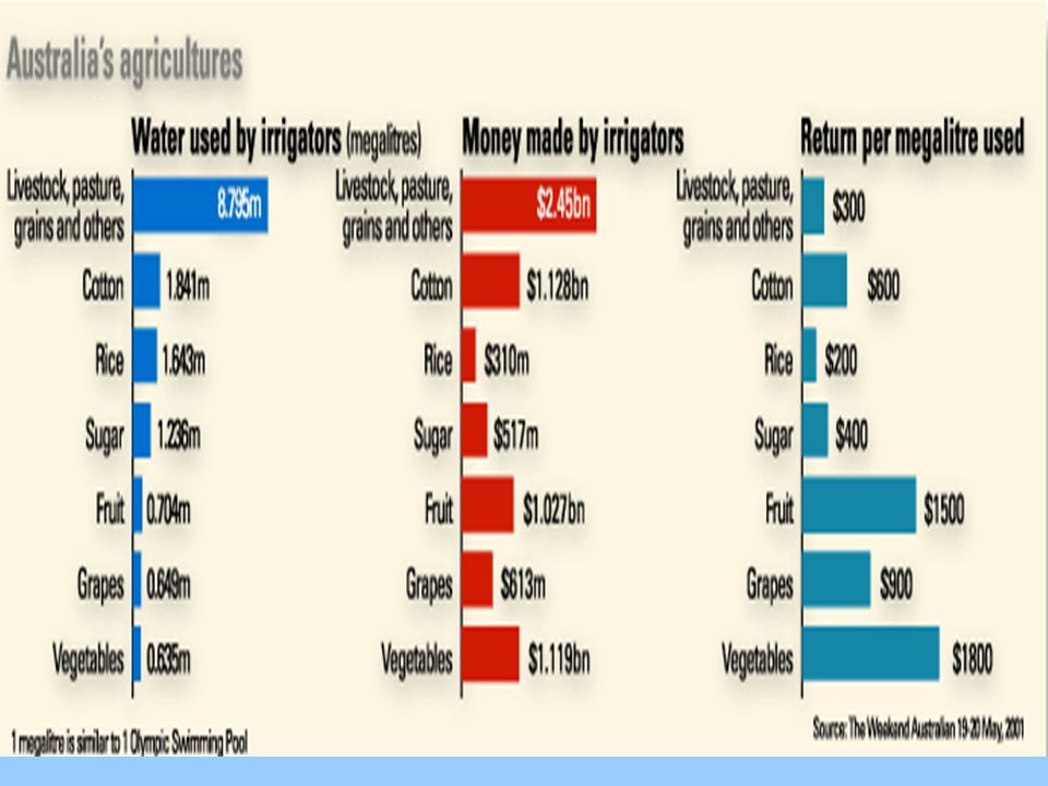
Cotton Today, cotton is mainly grown in the Northern part of the Murray-Darling Basin, along the Darling River and near the tributaries in northern New South Wales and southern Queensland. About 80 per cent of cotton crops are grown under irrigation. The Murray-Darling Basin accounts for over 93 per cent of Australia’s raw cotton production http://www.smh.com.au/news/water-issues/cotton-sucking-life-out-of- murray/2008/08/15/1218307227802.html August 2008http://www.smh.com.au/news/water-issues/cotton-sucking-life-out-of- murray/2008/08/15/1218307227802.html

11
Rice Most of Australia’s rice is also grown within the Murray-Darling Basin. In 1924 rice production began around the townships of Leeton and Griffith in the Murrumbidgee Irrigation Area. Rice is now the major irrigated cereal crop and is grown entirely in the Murrumbidgee and Murray valleys of New South Wales. The annual rice production in Australia is between 1 and 1.7 million tonnes, with 1.2 million tonnes produced in 2002. Rice requires more water to grow than cotton.

12
Vineyards, Citrus, Fruit and Nut orchards Today, vineyards, citrus, fruit and nut orchards cover approximately 30,000 hectares of irrigated land and produce one third of Australia’s wines and citrus fruit. Up to 90 per cent of South Australia’s citrus, stone fruits and nuts are produced in the area. Angas Park, Australia’s largest producer of dried tree fruit, has a plant in Loxton employing a large team of full-time and seasonal workers.

13
Vineyards The Riverland has also become the largest wine-producing region in Australia and most major Australian wine companies source grapes from the area. The National Wine Centre of Australia provides more information about Riverland wineries.National Wine Centre of Australia

14
Land degradation: What is it? Land degradation is any change in the land that reduces its existing or potential productivity.

15
Land degradation Our soil resources are an important natural asset, and their degradation is a significant concern to Australian farmers, governments and the general public. When left untreated, degraded soil reduces agricultural productivity, while salinity can damage buildings and infrastructure such as water pipes, roads and sewers. Degradation can also damage habitat for wildlife, kill micro-organisms that live in the soil, and harm the quality of our inland waters.

16
Causes

17
Land clearing

18
Irrigation

19
Video http://www.powerhousemuseum.com/ed ucation/ecologic/aussalt.htm Why is Aust So Salty video. Need to open it in broadband 6 minshttp://www.powerhousemuseum.com/ed ucation/ecologic/aussalt.htm

20
Salinity Where is it and why?

22
Soil Salinity Salinity occurs when the water table rises, bringing natural salts to the surface (in sufficient quantity, these salts are toxic to most plants). When trees or other deep-rooted vegetation are replaced with vegetation that uses less water, the water table may rise to cause dryland salinity. (If the water table rises through increased irrigation then irrigation salinity can occur.

23
Dryland Salinity is where the water table rises after more water infiltrates due to the clearing of trees. Dryland Salinity

24
Recharge and leakage Water `leakgage' beneath the root zone and entering internal drainage and groundwater systems has increased. Ground water recharge is the amount of water being added to the ground water. If this is higher than discharge, which is the amount of water lost from the ground water, then the water table rises. As it does, the water dissolves salt held in the soil profile, and the salt becomes more and more concentrated as the water moves upwards. If the salty water keeps rising, it eventually reaches the surface and subsurface layers of the soil. The water evaporates, leaving the salt behind.

25
Dryland salinity in WA

36
Irrigation Salinity Irrigation Salinity is where the water table rises due to excessive irrigation meaning extra water infiltrates.

42
Concentrated salt at the surface will kill vegetation. Also plants trying to survive in saline areas are preferentially grazed. Removing vegetation causes problems with wind and water erosion and lost production.

43
Salinity Forecasts State/Territory20002050 New South WalesNew South Wales181 0001 300 000 VictoriaVictoria670 0003 1 100 000 South AustraliaSouth Australia390 000600 000 Western AustraliaWestern Australia4 363 0008 800 000 TasmaniaTasmania54 00090 000 QueenslandQueenslandnot assessed3 100 000 Total 17 000 000 http://www.abc.net.au/water/stories/s15 72428.htmhttp://www.abc.net.au/water/stories/s15 72428.htm Water facts on Salinity

44
Degradation Our soil resources are an important natural asset, and their degradation is a significant concern to Australian farmers, governments and the general public. When left untreated, degraded soil reduces agricultural productivity, while salinity can damage buildings and infrastructure such as water pipes, roads and sewers. Degradation can also damage habitat for wildlife, kill micro- organisms that live in the soil, and harm the quality of our inland waters.

46
Murray Darling Show Clickview 16 min video River’s End 60 mins 2008 And clickview 507 Catalyst 2008.05.01 http://www.abc.net.au/water/stories/s 2003556.htmhttp://www.abc.net.au/water/stories/s 2003556.htm

47
Murray Darling is the 7th biggest river system on the planet is Australia's largest and most developed river system covers more than 1 million square kilometres of land provides drinking water for over 3 million people encompasses 30,000 wetlands represents much of Australia's unique flora and fauna provides over 41% of Australia's gross value of agricultural production once boasted 28 billion trees, yet now has only 5 billion

55
Murray Darling Basin Stats http://www.abs.gov.au/ausstats/abs@.n sf/mf/4610.0.55.007http://www.abs.gov.au/ausstats/abs@.n sf/mf/4610.0.55.007

56
Total Catchment Management Is the integrated management of all landuse types within a catchment. A catchment is the total area from which material is received be it rainfall or deposition from upstream.

57
Individual responses responses to salinity

58
Engineering methods Engineering methods that intercept surface water through banks or shallow drains are used for recharge control. Good quality water harvested by pumping or water diversion can be reused elsewhere on a property for irrigation or stock watering, by making productive use of water that may otherwise be a problem once it intercepts salt in the landscape.

59
Protection of remnant native vegetation Management and protection of remnant native vegetation is the first step in working towards a higher water-using landscape. Native vegetation over a substantial part of a catchment provides optimum recharge control as most salinisation is the consequence of water balance change that followed tree clearing.

61
Contour ploughing Contour ploughing of hillsides frequently prevents water from flowing downhill. In other cases, where the slope is greater, contour banks will successfully retain and divert water flow into absorption areas. On gently sloping grazing land, run-off can often be successfully controlled by well-spaced furrows, ploughed on the contour.

62
Prevention and Control The formation of contour banks, contour ploughing, the growing of wind breaks and the stabilising of loose soil by crops.

64
Individual responses Strips farming following the contour to combat water erosion on a slope.

65
Tree planting Trees planted in the form of shelter belts and windbreaks can provide excellent counters to wind erosion in exposed areas. Superior to all these techniques, however, is the stabilisation of surface soil by the provision of permanent, adequate vegetative cover. Hence a considerable volume of research has been devoted to selecting plants suitable for vegetative regeneration in areas which experience long dry periods.

66
Group response to the issue http://landcaresa.org.au/murray/initiati ve/index.html Landcarehttp://landcaresa.org.au/murray/initiati ve/index.html

67
Group responses http://landcaresa.org.au/murray/initiati ve/index.html Landcare websitehttp://landcaresa.org.au/murray/initiati ve/index.html

72
Government responses

73
Government response Fears about environmental damage in many of the region's parched ecosystems have prompted the government to begin buying back water entitlements from farmers who want to sell, in a $3 billion scheme that aims to return 34,000 megalitres to the environment over the coming decade.

74
Government response The Senate has passed a motion to set up an urgent inquiry aimed at replenishing the Murray River system's lower reaches. August 2008

75
Government response Part of federal funding for South Australia will see $120 million spent to pipe river water to lower lakes communities from further upstream, where salinity is lower.

76
An adventurer has the final say http://www.abc.net.au/news/stories/20 07/09/25/2042589.htmhttp://www.abc.net.au/news/stories/20 07/09/25/2042589.htm

Similar presentations


>")


