Download presentation
Presentation is loading. Please wait.

1
Understanding Google Earth and GIS Matthew Mullenax, GISP, CFM Parsons Brinckerhoff

2
Presentation Outline Overview of Google Earth Functionality Google Earth and GIS Myrtle Beach Fire Example Importing/Exporting Data Additional Resources

3
verview of Google Earth Released in June 2005. Free, downloadable desktop software. Displays imagery of the Earth’s surface. Uses Keyhole Markup Language (.kml) for data >400,000,000 Google Earth Users worldwide (GIS Snobs take note!).
 for data >400,000,000 Google Earth Users worldwide (GIS Snobs take note!)..")
7
Google Earth Functionality Navigation Searches Measurements Geocode and GPS import Image overlay Data creation Time slider

8
Google Earth Functionality (cont’d) Street View Weather data Roads, Administrative Boundaries, Cities, Terrain layers
 Street View Weather data Roads, Administrative Boundaries, Cities, Terrain layers")
9
When using GE, be mindful… Most elevation values based on NASA SRTM. Difficult to determine resolution, exact acquisition date and source of imagery. Lack of consistent resolution. Imagery might not be most recent, publicly-available data. Cannot create attributes or metadata***. Documentation not overly detailed, user-support not extensive. Uses Lat/Lon WGS84 only. Virtually no analytical or map customization functionality (Decision-makers take note!).
..")
10
CD player vs. Recording Studio

11
Can play music. Low cost. Narrow range of functionality. Allows anyone to access/consume music. Can play music. High cost. Wide range of functionality. Allows highly technical to create music.

12
CD player vs. Recording Studio Bottom line: both were created for different yet related purposes. Recording studio can create and produce music; CD player with reduced functionality allows for access to music and means of dissemination to a broad audience.

13
Google Earth and GIS Can display geographic data. Low cost. Content-delivery and visualization environment. Easy to access and learn. Can display geographic data. High cost. Intelligent data structure and analytical environment. Technical and robust.

14
Google Earth and GIS Bottom line: both were created for different yet related purposes. GIS can author and serve information not easily accessible to the public who can interact with the data in Google Earth. Also, Google Earth can author and serve information with minimal training that can be brought into a GIS for enhanced analysis and map production.

15
Myrtle Beach Fire Example Late April 2009 Large fire in north suburban Myrtle Beach, SC Burned over 1,000 acres, destroyed 70 homes with another 100 damaged In case placed on standby for a federal disaster declaration…need information on amount and level of damage, accessibility, disaster location, etc.

16
Photo credit: Myrtle Beach Sun-Times

17
Myrtle Beach Fire (cont’d) Searched for GIS data, came across Google Earth data. Produced by Myrtle Beach Sun-Times staff who collected and verified information. (public participatory GIS by non-GIS personnel) Contained location of road closures, extent of fire, locations of shelters, geo-linked photos and videos, etc. Able to import into GIS for proximity analysis and map creation AND forward Google Earth file to management for their quick review.
 Contained location of road closures, extent of fire, locations of shelters, geo-linked photos and videos, etc. Able to import into GIS for proximity analysis and map creation AND forward Google Earth file to management for their quick review..")
19
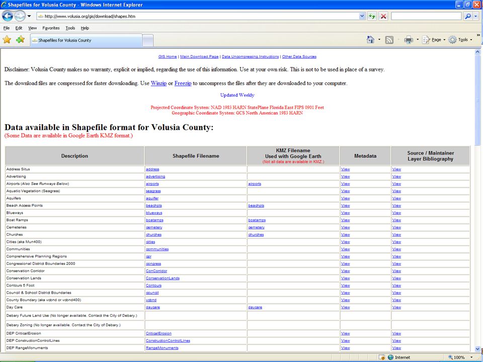
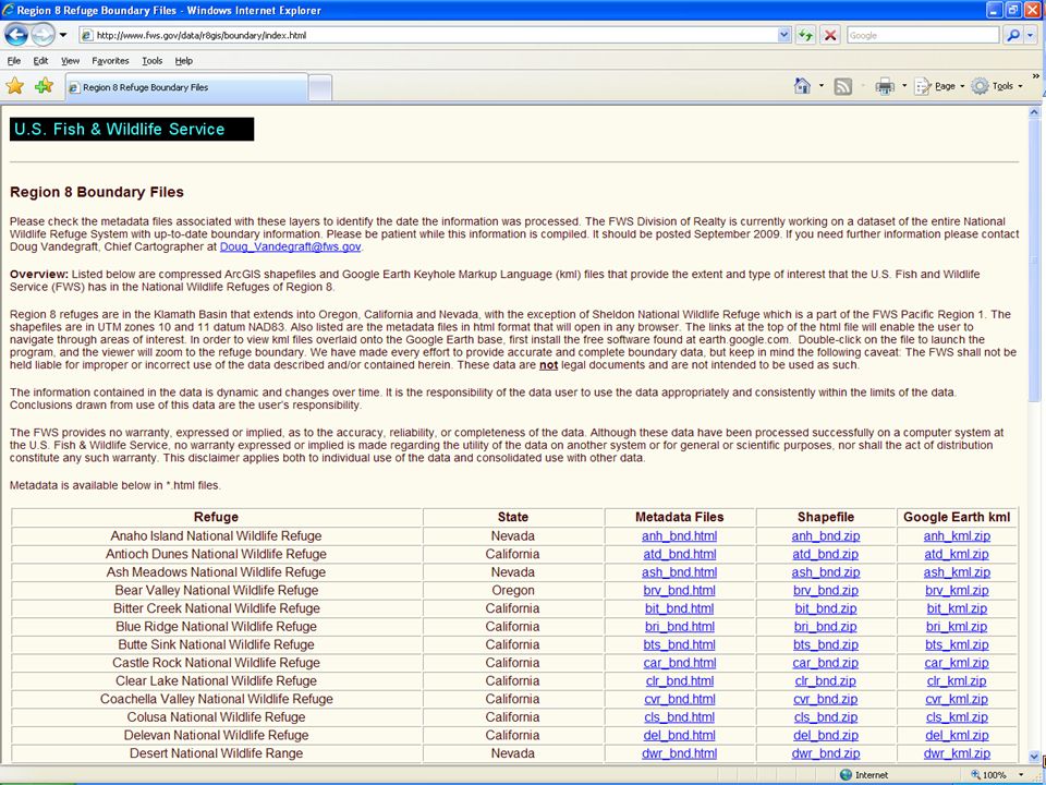
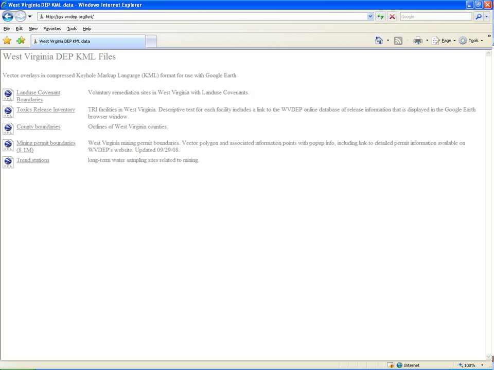
Importing/Exporting Data Out of the box: Tools in ArcGIS can directly export map or data to.kml as an image. Google Earth can directly import shapefiles (not.gdb). Excel workaround (Google Earth>.kml> Excel>.dbf> ArcGIS> AddXY Event >.shp) Scripts and Tools: Shapefile/geodatabase to.kml using: Export to Kml script (Kevin Martin-City of Portland OR). .kml to shapefile using: Kml2Shp (Zonum Solutions) Convert KML to SHP (Jason Parent) Convert Google Earth Path (KML) to SHP (Denis Beaulieu) XTools can import/export.kml in ArcGIS (~$200 license; 30 day free trial available).
. Excel workaround (Google Earth>.kml> Excel>.dbf> ArcGIS> AddXY Event >.shp) Scripts and Tools: Shapefile/geodatabase to.kml using: Export to Kml script (Kevin Martin-City of Portland OR). .kml to shapefile using: Kml2Shp (Zonum Solutions) Convert KML to SHP (Jason Parent) Convert Google Earth Path (KML) to SHP (Denis Beaulieu) XTools can import/export.kml in ArcGIS (~$200 license; 30 day free trial available)..")
20
Additional Resources: Google Earth and ESRI ArcGIS Desktop User Guides Google Earth Pro – 7 day free trial available (http://earth.google.com)http://earth.google.com Import GIS data in Google Earth (GE tutorial) Conroy, et al. 2008 “Google Earth, GIS, and the Great Divide: A new and simple method for sharing paleontological data.” Journal of Human Evolution 55:4, pgs 751-755. Vander Veen. 2009. “ESRI’s Jack Dangermond: GIS Brings Better Government Transparency.“ Government Technology 22:5, pgs 14-19.

21
Fun Additional Resources: Blurred Out: 51 Things You Aren’t Allowed to See on Google Earth Blurred Out: 51 Things You Aren’t Allowed to See on Google Earth Strangest Sights in Google Street Views Strangest Sights in Google Street Views

22
Questions?

Similar presentations


 software services with new and existing clients. Presentation.>")


