Download presentation
Presentation is loading. Please wait.

1
Where on Earth are we?

2
Globe to map?

3
Projecting the Earth The position of a place on the Earth's is defined by coordinates of latitude and longitude. The framework of parallels and meridians representing the values of latitude and longitude is called a graticule. When features on the curved surface of the Earth are represented on a flat surface, their shape or size will always be subject to distortion. Methods for representing these features on paper are known as map projections.

4
Three widely used map projections.
If a light were placed at the centre of a transparent Earth, the shapes of the countries would be thrown as shadows on a sheet of paper. If the paper is flat, the azimuthal projection results. If it is wrapped around a cylinder or in the form of a cone, the cylindrical or conic projections result.

5
Ordnance Survey maps are based on a particular type of map projection called the Transverse Mercator projection.

6
Why ordnance survey? In the United Kingdom, biologists are extremely fortunate in the quality of their maps. The Ordnance Survey which has been providing accurate, reliable and detailed geographic information for more than 200 years. The Ordnance Survey is so called because it was first established to produce accurate maps for use by the military, ordnance being military stores, and implements of war.

7
The OS grid OS maps are based on a regular metric grid.
Places are located by their X and Y coordinates on the grid.

8
The true origin The longitude line 2° West runs roughly through the middle of Great Britain and is chosen to be the central meridian of the map projection. On the central meridian the true origin of the map projection is chosen, at latitude 49° North. From this point the position of any feature can be given, in terms of x metres east or west, and y metres north, of the true origin.

9
The true origin The disadvantage in that there will be positive and negative numbers, signifying locations to the east and west of the central meridian. This is potentially confusing!

10
The false origin To eliminate this problem the grid numbering is taken from a point 100 km north and 400 km west of the true origin of the projection. This point is known as the false origin. Despite its name, this false origin is the origin of all National Grid references.

11
Northings and Eastings
The National Grid is designed to cover the whole of Great Britain and extends 700 km to the east and 1300 km to the north of the false origin. Within this framework we can use a National Grid reference to state the position of any point in Britain, to any level of precision that we require, km, m, cm. Essentially, we need to state two numbers: an easting (along the horizontal axis) and a northing (along the vertical axis).
 and a northing (along the vertical axis).")
12
Grid lines The National Grid is often subdivided into 100 km squares, with grid lines parallel to and at right angles to the central meridian of the map projection. All points on the central meridian have an easting of 400 km. We are just 11 km West of the central median. Grid lines may also be shown at 10 km, 1 km and 100 m intervals on various map series.

13
Grid lines and latitude/longitude
Because the graticule exists on the curved surface of the Earth, and the grid exists on the flat mapping plane, an exact fit of grid and graticule cannot be achieved. The Transverse Mercator map projection is designed to minimise the distortion of the grid.

14
Full national grid coordinates
If you are working with coordinates in mathematical formulae, you will need to use full easting and northing coordinates. These are given in metres with respect to the false origin. Eastings can be up to 700,000 m and northings up to 1,300,000 m.

15
The grid square convention 1
To reduce the number of digits required to give a National Grid reference, a system of grid squares denoted by letters is used. The largest are 500 km by 500 km squares, each square designated by a prefix letter. This grid is larger than the National Grid because it was adopted from a military grid system already in use. Note: the 25 letters are the letters of the alphabet, excluding the letter 'I‘ which can be confused with 1.

16
The grid square convention 2
H, N, O, S and T are the letters denoting the National Grid 500 km squares which cover Great Britain. H covers the Shetlands and Orkney N, the rest of Scotland and Northern England S, Wales and England T, England. We are currently in square S.

17
The grid square convention 3
Each 500 km by 500 km square is divided into twenty-five 100 km by 100 km squares. Each of the twenty-five 100 km by 100 km squares is designated by the second prefix letter to be quoted in the National Grid reference. Again, these use the 25 letters of the alphabet, excluding the letter 'I'. We are in square D.

18
The grid square convention 4
The diagram, representing the grid of 100 km by 100 km squares covering Great Britain, identifies the two designated prefix letters for each square and beneath. Under the system no two 100 km squares can have the same combination of prefix letters. We are in square SD.

19
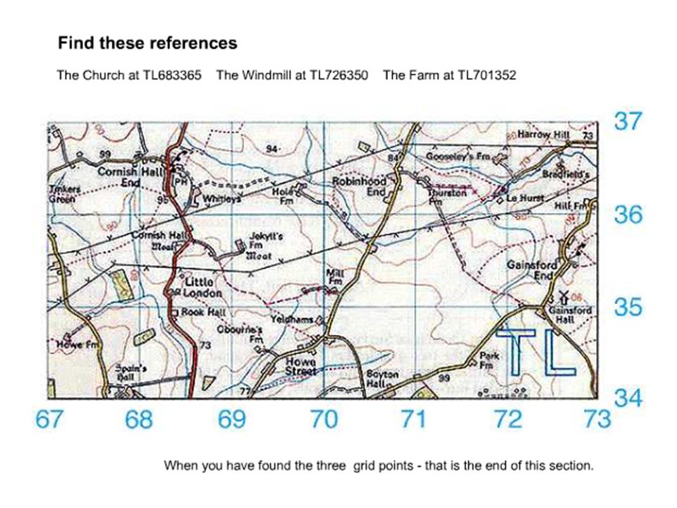
Giving a map reference

20
The 100 km square The map square will be printed at the corner of your map e.g. SE

Similar presentations


>")


