Download presentation
Presentation is loading. Please wait.

1
USGS, Denver, Colorado USA
PRMS/MMS: A Model and Modeling Framework for Use in Water- and Environmental-Resources Management George Leavesley USGS, Denver, Colorado USA

2
Overview PRMS MMS Focus Areas in Model Development Summary
Model Processes Toolbox Summary

3
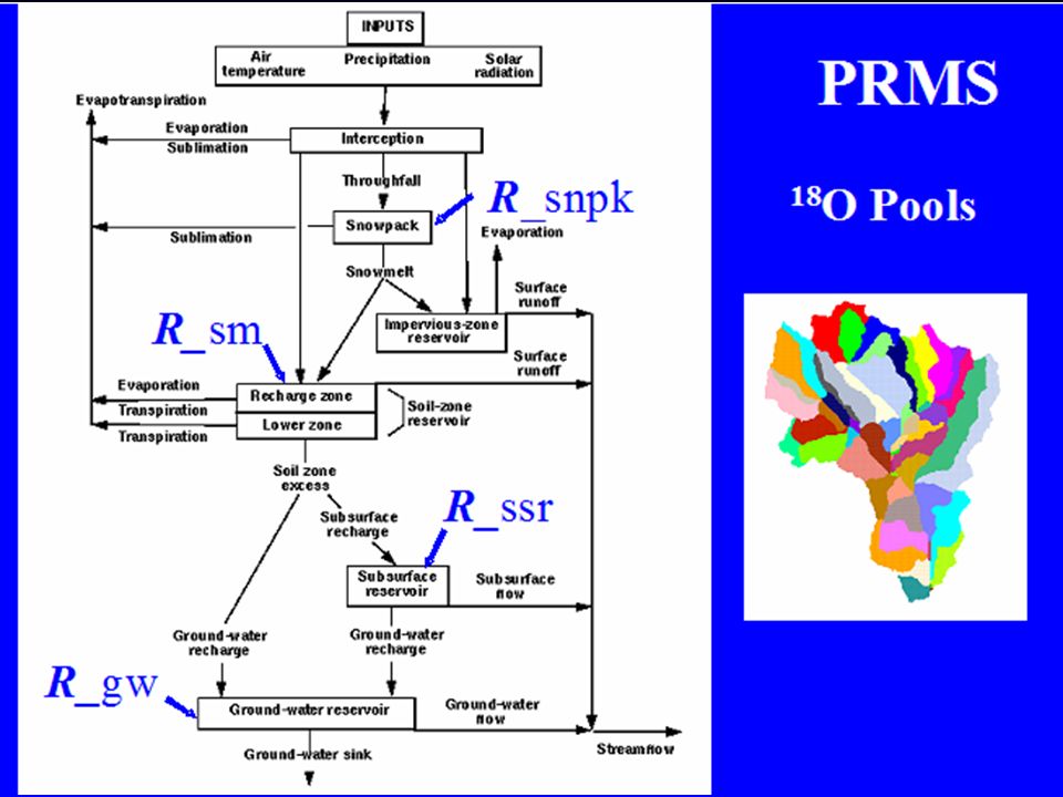
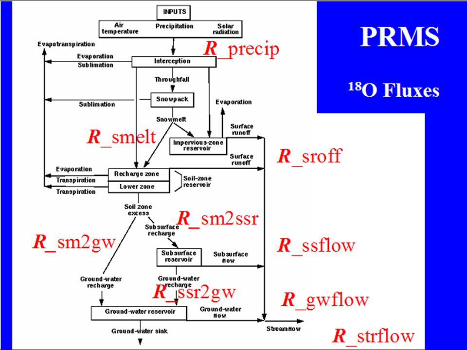
PRMS

4
PRMS Features Modular Design Deterministic Distributed Parameter
Daily and Storm Mode User Modifiable

5
Distributed Parameter Approach
Hydrologic Response Units - HRUs HRU Delineation Based on: - Slope Aspect - Elevation Vegetation - Soil Precip Distribution

6
HRU DELINEATION AND CHARACTERIZATION
Grid Cell Hydrologic Response Units (HRUs) Polygon Hydrologic Response Units (HRUs)
 Polygon Hydrologic Response Units (HRUs)")
7
PRMS -- HRU Delineation
Topographic Pixelated

8
CASCADING FLOW PLANES Overland Flow Path Channel Segment
1 2 3 1 7 8 Overland Flow Path 10 9 1 Channel Segment 3 Channel Junction 4 3 6 2 Overland Flow Plane 2 4 width Grass/Agriculture Bare Ground/Rock 5 12 11 Trees length Shrubs

9
The Modular Modeling System (MMS) An integrated system of computer software developed to:
Provide a common framework for model development and operational applications Facilitate the integration of multi-disciplinary modeling approaches for use in addressing complex, multi-objective, resource-management problems Provide a toolbox-approach to the development of resource-management, decision-support systems

10
MODULAR MODELING SYSTEM (MMS)
Model Builder MMS Interface Object User Interface

11
LEVELS OF MODULAR DESIGN
PROCESS MODEL FULLY COUPLED MODELS LOOSELY COUPLED MODELS RESOURCE MANAGEMENT DECISION SUPPORT SYSTEMS ANALYSIS AND SUPPORT TOOLS

12
PRMS

13
WEBMOD PRMS National Weather Service - Hydro17 TOPMODEL

14
Use Chemical and Isotopic Tracers to Evaluate Simulated Flow Paths and Residence Times
Next step: Use tracers to constrain the hydrologic solutions Chloride Potassium DOC Oxygen Isotopes Bedrock Alkalinity Equifinality vs uncertainty in time and place.

15
Coupled WEBMOD and PHREEQC

18
LEVELS OF MODULAR DESIGN
PROCESS MODEL FULLY COUPLED MODELS LOOSELY COUPLED MODELS RESOURCE MANAGEMENT DECISION SUPPORT SYSTEMS ANALYSIS AND SUPPORT TOOLS

19
GSFLOW -- Coupled PRMS, MODFLOW, SFR, and Unsaturated Zone Models
PRMS to SFR Unsaturated Zone Model: PRMS to UNSAT UNSAT to MODFLOW PRMS to MODFLOW MODFLOW to SFR Streamflow

20
2x vertical exaggeration
Sagehen Creek Model 2x vertical exaggeration Springs Stream gage

21
Ground-Water Discharge & Saturation Excess

22
LEVELS OF MODULAR DESIGN
PROCESS MODEL FULLY COUPLED MODELS LOOSELY COUPLED MODELS RESOURCE MANAGEMENT DECISION SUPPORT SYSTEMS ANALYSIS AND SUPPORT TOOLS

23
Aquatic Habitat Models
Watershed Model Hydraulics Model Fish Model

24
Aquatic Habitat Models Results
ft3/s ft2

25
LEVELS OF MODULAR DESIGN
PROCESS MODEL FULLY COUPLED MODELS LOOSELY COUPLED MODELS RESOURCE MANAGEMENT DECISION SUPPORT SYSTEMS ANALYSIS AND SUPPORT TOOLS

26
Watershed and River Systems Management Program
Recreation Watershed and River Systems Management Program Municipal & Industrial Irrigation Hydropower Research and development of decision support systems and their application to achieve an equitable balance among water resource issues. Riparian Habitat Endangered Species

27
WARSMP Basins Currently Active
Gunnison, Truckee, Upper Rio Grande, Yakima Under Development San Juan, Umatilla, Upper Columbia Future Bitterroot, Carson, Central Platte, Lower Rio Grande, Salmon WARSMP Basins

28
Generic DSS Framework for a Wide Range of Management Issues
Any Resource Management Model Climate Data Source Any Database DMI DMI DMI MMI Object User Interface Interface for data visualization and modeling Modular Modeling System Physical Process Models

29
Database-Centered Decision Support System
Hydromet Real-time climate data feed Hydrologic Database DMI DMI USBR RiverWare Reservoir and River System Operations Model DMI DMI USGS Object User Interface Interface for data visualization and modeling USGS Modular Modeling System Precipitation/Runoff Model (PRMS)
")
30
OBJECT USER INTEFACE (OUI)
")
31
Environmental Database-Centered Decision Support System (DSS)
Resource Database Resource Management Alternatives SIMPPLLE Vegetation Dynamics Models (USFS) Object User Interface Interface for data visualization and modeling Modular Modeling System Physical Process Models DMI
 Object User Interface. Interface for data visualization. and modeling. Modular Modeling System. Physical Process Models. DMI.")
32
Focus Area Model Processes
Precipitation Distribution Snow accumulation and melt proceses Parameter estimation in ungauged basins

33
Precipitation Interpolation Methods
Inverse distance weighting Kriging Multiple linear regression Climatological multiple linear regression Locally weighted polynomial k nearest neighbor …

34
PRMS Snowpack Energy Balance Components

35
Evaluating MM5 Output Using PRMS

36
Nested Domains for MM5

37
HRU Configurations Polygon Grid

38
HRU Configurations

39
(Climate Station Data)
Effects of HRU Configuration and Data Source (Yampa Springs) Grid Polygon (Climate Station Data) HRU Type/ Data Size
 Grid. Polygon. (Climate Station Data) HRU Type/ Data Size.")
40
Satellite vs Modeled Snow Covered Area
east

41
Animas Basin Snow-covered Area Year 2000
Simulated Measured (MODIS Satellite) Error Range <= 0.1
 Error Range <= 0.1.")
42
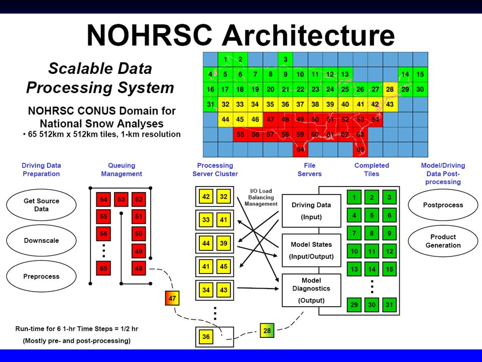
NOHRSC Snow Modeling Framework
Data Assimilation 2 Temperature Relative Humidity Wind Speed Solar Radiation Atmos. Radiation Precipitation Precipitation Type Hourly Input Gridded Data (1 km) Soils Properties Land Use/Cover Forest Properties Static Gridded Data (1 km) Snow Energy and Mass Balance Model Blowing Snow Model Radiative Transfer Model State Variables for Multiple Vertical Snow & Soil Layers Snow Water Equivalent Snow Depth Snow Temperature Liquid Water Content Snow Sublimation Snow Melt 1 Snow Observations Snow Water Equivalent Snow Depth Snow Cover 3 NSA Product Generation Interactive Maps Digital Data Discussions
 Soils Properties. Land Use/Cover. Forest Properties. Static Gridded. Data (1 km) Snow Energy and Mass Balance Model. Blowing Snow Model. Radiative Transfer Model. State Variables for. Multiple Vertical. Snow & Soil Layers. Snow Water Equivalent. Snow Depth. Snow Temperature. Liquid Water Content. Snow Sublimation. Snow Melt. 1. Snow Observations. Snow Water Equivalent. Snow Depth. Snow Cover. 3. NSA Product. Generation. Interactive Maps. Digital Data. Discussions.")
43
NOHRSC Snow Model Physics

45
National Snow Analyses (NSA)
Data Products Interactive Maps Time Series Plots Text Discussions Snow Information Products High-resolution Daily and Hourly Gridded Snow Data Sets of Fused Model and Observations Local Information (1 km2) Continental U.S. Information Snow Water Equivalent Snow Depth Snow Density Snow Sfc. Temperature Snow Avg. Temperature Snow Melt Sublimation Snow Wetness Archived at NCDC, NSIDC, and NDFD (soon)
 Continental U.S. Information. Snow Water Equivalent. Snow Depth. Snow Density. Snow Sfc. Temperature. Snow Avg. Temperature. Snow Melt. Sublimation. Snow Wetness. Archived at NCDC, NSIDC, and NDFD (soon)")
46
Animas Durango 1805 km2

47
Animas River Basin, CO

48
Predicted and Measured Streamflow
Animas Basin, CO PREDICTED MEASURED

49
Animas Basin SWE April 1 (in.) May 1 SNODAS PRMS
 May 1 SNODAS PRMS")
50
Animas Basin SWE (in.) April 1 May 1 SNODAS PRMS
 April 1 May 1 SNODAS PRMS")
51
SWE Difference on Selected HRUs
SWE_diff = SNODAS - PRMS

52
PRMS OBS Q (cfs) Animas PRMS SNODAS melt (in) PRMS SNODAS swe (in)
 Animas PRMS SNODAS melt (in) PRMS SNODAS swe (in)")
53
a priori Parameter Estimation
IAHS Predictions in Ungauged Basins (PUBs) predict the fluxes of water and associated constituents from ungauged basins, along with estimates of the uncertainty of predictions Model Parameter Estimation Experiment (MOPEX) develop techniques for the a priori estimation of the parameters used in land surface parameterization schemes of atmospheric models and in hydrologic models
 predict the fluxes of water and associated constituents from ungauged basins, along with estimates of the uncertainty of predictions. Model Parameter Estimation Experiment (MOPEX) develop techniques for the a priori estimation of the parameters used in land surface parameterization schemes of atmospheric models and in hydrologic models.")
54
Gauged Subbasins in the Upper Gunnison Basin, CO
East River Taylor River Tomichi Creek Lake Fork Cochetopa Creek

55
Forecasting at Internal Nodes
Hunter Creek nr Aspen, Colorado Hunter Midway No Name Gage Trans-mountain Diversion Points HRUs

56
GIS WEASEL Delineation: Only requires elevation Grid as input
Interactively delineate Area of Interest Many kinds of features Streams Elevation bands Landuse Contributing areas Topographic index ……

57
Satellite SW Radiation (U Md)
Vegetation Type (USFS) Vegetation Density (USFS) Land Use-Land Cover (USGS) DIGITAL DATABASES STATSGO Soils (USDA) Satellite SW Radiation (U Md) Monthly PET
 Vegetation Density (USFS) Land Use-Land Cover (USGS) DIGITAL DATABASES. STATSGO Soils (USDA) Satellite SW Radiation (U Md) Monthly PET.")
58
AUTOMATED PARAMETER ESTIMATION USING THE GIS WEASEL

59
MOPEX US Basin Locations
Workshop I Workshop II: 20 basins in France Workshop ? 438 basins

60
Participants MOPEX Workshop I
NWS (SWB & SAC) Meteo France (ISBA) Russian Academy of Science (SWAP) UC Berkeley / Princeton (VIC) Cemagref, France (GR4J) NCEP (NOAH) USGS (PRMS) Yamanashi University (BTOPMC) Swedish Meteor. and Hydro. Institute, Sweden (HBV) University of Alberta, Canada (SAC) University of Newcastle, Australia University of Arizona Centre for Ecology and Hydrology, UK Oregon State University Wageningen University, The Netherlands National Institute of Hydrology, Canada University of New Hampshire
 Meteo France (ISBA) Russian Academy of Science (SWAP) UC Berkeley / Princeton (VIC) Cemagref, France (GR4J) NCEP (NOAH) USGS (PRMS) Yamanashi University (BTOPMC) Swedish Meteor. and Hydro. Institute, Sweden (HBV) University of Alberta, Canada (SAC) University of Newcastle, Australia. University of Arizona. Centre for Ecology and Hydrology, UK. Oregon State University. Wageningen University, The Netherlands. National Institute of Hydrology, Canada. University of New Hampshire.")
61
MOPEX Workshop I Results
Average daily Nash-Sutcliffe CE for all 12 basins Uncalibrated Calibrated PRMS NWS VIC PRMS NWS VIC

62
Ensemble Modeling 10 Model Ensemble

63
Dill Basin, Germany Topography 750 km2 Sub-basins Land Use

64
Bias & Efficiency of Model Simulations Original Precip Data Set

65
Focus Area Toolbox

66
TOOLBOX TOOL PITCH Parameterizer (GIS Weasel)
")
67
TOOLBOX TOOL PITCH Parameterizer (GIS Weasel) Optimizer (Luca)
 Optimizer (Luca)")
68
Statistical and graphical sensitivity and uncertainty analysis tools
TOOLBOX Statistical and graphical sensitivity and uncertainty analysis tools TOOL PITCH Parameterizer (GIS Weasel) Optimizer (Luca) Analyzer
 Optimizer (Luca) Analyzer.")
69
OMS

70
Integrated Framework Development
Collaborative effort to integrate the Object Modeling System (OMS) and the Modular Modeling System (MMS) OMS Platform ModelCore ModelBuilder RZWQM PRMS Database Netbeans IDE, Sun Forte,… Java Compiler XML Testing C++ Other… - ARS USGS NRCS - (NWS) -Friedrich Schiller University, Germany Branding
 and the Modular Modeling System (MMS) OMS Platform. ModelCore. ModelBuilder. RZWQM. PRMS. Database. Netbeans IDE, Sun Forte,… Java Compiler. XML. Testing. C++ Other… - ARS - USGS - NRCS - (NWS) -Friedrich Schiller University, Germany. Branding.")
71
Working with the NRCS and NWS to develop a Modular Modeling System forecasting toolbox using MMS/OMS and PRMS

72
Integrated Adaptive-Modeling and Decision-Support System Summary
Facilitates multi-disciplinary integration of models and tools to address the issues of water and environmental-resource management. Allows rapid evaluation of the effects of decision and management scenarios. Allows incorporation of continuing advances in physical, social, and economic sciences. Provides an effective means for sharing scientific understanding with stakeholders and decision makers. Open source software design allows many to share resources, expertise, knowledge, and costs.

73
MORE INFORMATION http://wwwbrr.cr.usgs.gov/mms
Similar presentations

>")


: A Toolbox for Water- and Environmental-Resources Modeling and Management G.H. Leavesley, S.L. Markstrom, R.J. Viger,>")

 Description of Yakima River Basin and Yakima Storage Project MMS and Yakima River Basin models Global Climate-Change.>")


 Model Input>")


