Download presentation
Presentation is loading. Please wait.

1
ODOT Wildlife Hotspots Study RESULTS OF STATEWIDE ANALYSIS July 21, 2008 Melinda Trask Oregon Department of Transportation, Geo-Environmental Section, Salem OR Francesca Cafferata-Coe, Jessica Burton, Ellen Voth, and John Lloyd, Mason, Bruce & Girard, Inc., Portland OR

3
Types of Wildlife Collision Data Focused Road Kill Observations Possible to get accurate location and species info. Most expensive Expert Opinion Good for first cut; precursor to focused studies Subjective; not empirical Crash Records Used for national statistics Limited subjective reporting Data quality cannot be verified Dispatch Carcass Reports Most comprehensive option Data quality cannot be verified

4
Oregon's Highway Animal-Vehicle Collisions CRASH RECORDS: Avg. 400 wildlife collisions per year, past 14 years About 5,500 records statewide Less than 3% of all crash reports in Oregon 15 fatalities & 117 serious injuries in 14 years Crash records represent only a small portion of actual animal- vehicle collisions nationally (less than 10% of actual; literature) Dispatch Carcass Records 6 times more data in similar period Represents avg. 2,600 wildlife collisions per year, past 12 years About 32,000 records statewide in OR (12 years)
 Dispatch Carcass Records 6 times more data in similar period Represents avg. 2,600 wildlife collisions per year, past 12 years About 32,000 records statewide in OR (12 years).")
5
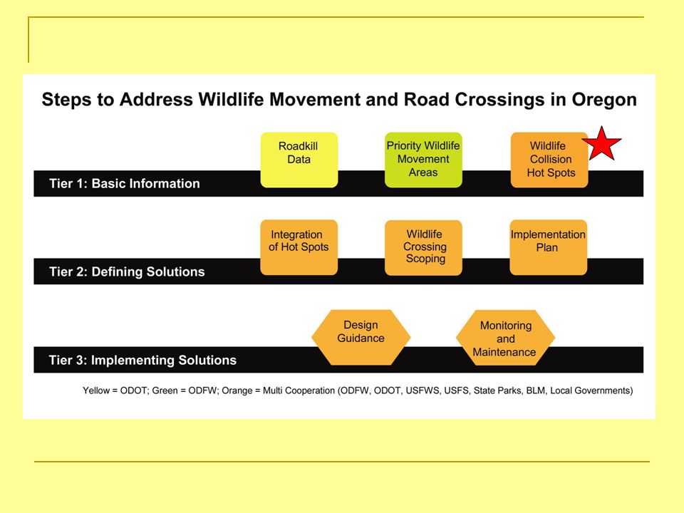
ODOT Wildlife Collision Prevention Plan Addressing wildlife passage is supported by the Governor and ODOTs current mission and goals, and particularly within the values of safety, accountability, and environmental stewardship. Current lack of information - we cannot adequately address the problem. Do we have a significant statewide road kill problem or just some areas? Need to prioritize wildlife movement corridors and highway barrier problem areas to make science-based decisions and cost- effective, versus ad-hoc. Need better tools to adequately address wildlife passage. Non-regulated but supported by FHWA, ODFW, USFWS, CETAS, nationwide attention.

6
Density: low medium high ODOT Wildlife Collision Hot Spot Analysis Uses existing carcass pick-up records Statewide, analytical approach Identify high frequency wildlife-vehicle collision zones Conducted pilot study in D10 to fine tune methods and determine the feasibility of statewide analysis US Hwy

7
Data Preparation - Methods 3 different types of record keeping Wildlife Incident Reports, call = RDKILL Animal Type, Deer & Elk Consistent Dates, 12 yeas of data (1995-2006) Location, +/- 0.5 mile Link Location to GIS Coordinates CAD_NUMCALLDATELOCATIONUNITS 95309256RDKILL101919955925 WALLACE RDHWY21 95309392RDKILL10201995HELMICK ROAD / 99 SR ;12600 HELMICK RD21AP 95309598RDKILL1020199521.5 228 SR3A20P 95312278RDKILL102319955.9 22 SR3A261 95312329RDKILL10231995SHERWOOD @ 99W SR MP 15.2-15.8/ ; 19025 SW PAC HWY3A52P 95312331RDKILL10231995HWY 212 / FORMORE CT4A30P
 Location, +/- 0.5 mile Link Location to GIS Coordinates CAD_NUMCALLDATELOCATIONUNITS RDKILL WALLACE RDHWY RDKILL HELMICK ROAD / 99 SR ;12600 HELMICK RD21AP RDKILL SR3A20P RDKILL SR3A261 99W SR MP / ; SW PAC HWY3A52P RDKILL HWY 212 / FORMORE CT4A30P")
8
Data Preparation - Results Original # Records 31,595 (100%) Step 1 - Data Processing Narrowing Acceptable Parameters25,216 (80%) (20% reduction) Cut out records older than 1995, duplicate records, non deer/elk, low precision (> 0.5 mi) Tabular Information Problems 21,335 (68%) (12% reduction) Poor location, highway nomenclature, or MP Not enough information in recorded data MP not referenced Step 2 - Linkage to GIS GIS Mapping Problems 17,824 (56%) * (11% reduction) Route ODOT Highway number * Final number of "good" records used in data analysis.
 Step 1 - Data Processing Narrowing Acceptable Parameters25,216 (80%) (20% reduction) Cut out records older than 1995, duplicate records, non deer/elk, low precision (> 0.5 mi) Tabular Information Problems 21,335 (68%) (12% reduction) Poor location, highway nomenclature, or MP Not enough information in recorded data MP not referenced Step 2 - Linkage to GIS GIS Mapping Problems 17,824 (56%) * (11% reduction) Route ODOT Highway number * Final number of good records used in data analysis.")
9
GIS Challenges 2 highway numbering systems in use Signed Highways State Highway Routes (ODOT internal system) Mileposts based on Routes not signed hwys Mileposts not unique on signed hwys Dispatch data generally refer to Routes Final dataset reduced to only records with equal hwys:route relationship
 Mileposts based on Routes not signed hwys Mileposts not unique on signed hwys Dispatch data generally refer to Routes Final dataset reduced to only records with equal hwys:route relationship")
10
Final Data Set

11
Nearest Neighbor Analysis 1 st cut to see if clustering is non-random Ripleys K Distribution Gives indication of scale of clusters Kernel Density Evaluation Shows location of clusters by density Analytical Methods

12
Results: Nearest Neighbor Analysis Carcass reports occur significantly closer together than would be expected by chance Does not identify where the clusters occur REGIONR1R2R3R4-5 Confidence Interval99% n100 t2.63 Expected Mean NN Dist. (ft)39512944807.11201 Standard Deviation (ft)199.177.7213.7510.87 Standard Error of the Mean19.917.7721.3751.087 CI 1/2 width (ft)52.2820.413.612.86 Lower Confidence Limit (ft)38992923803.41198 Upper Confidence Limit (ft)40032964810.71204 Observed Mean NN Dist.(ft)34842215490.7731.9 Nearest Neighbor Index*0.880.750.61 * If <1.0, indicates significant clustering
 Standard Deviation (ft) Standard Error of the Mean CI 1/2 width (ft) Lower Confidence Limit (ft) Upper Confidence Limit (ft) Observed Mean NN Dist.(ft) Nearest Neighbor Index* * If <1.0, indicates significant clustering.")
13
Results: Ripleys K Distribution Looks at a range of scale distances Shows significant clustering of WVCs at all distances Does not identify cluster locations Region 3 shown (other Regions essentially the same)
")
14
Results: Kernal Density Evaluation Analogous to a histogram of reports per unit area with infinitely small bins Produces an estimate of risk for each point. Highlights highway segments with higher density probabilities than others Results Depend on: Density of points Relative proximity of points Study area Method of categorizing Ranking or # bins

17
Discussion This study did not address why hotspots are found in these areas. vehicle speed, traffic volume, movement barriers, adjacent habitat structure, animal distribution, travel corridors, etc. Necessary to make sound management decisions ODOT can pay for wildlife crossing improvements Justified under PD-04 FHWA Enhancement program (Category 11) Oregon Transportation Plan (Goal 4.1.1) SAFETEA-LU Section 148 (approved uses of safety funds) Hazard Elimination Program (HEP) Highway Safety Improvement Program (HSIP)
 Oregon Transportation Plan (Goal 4.1.1) SAFETEA-LU Section 148 (approved uses of safety funds) Hazard Elimination Program (HEP) Highway Safety Improvement Program (HSIP).")
18
Next Steps ?? 1. Convert data to vector and link to Hwy/MP 2. Clean-up data for Regions – spreadsheet 3. Uses in Planning 4. Uses in Project Development 5. Uses in Safety Projects?? RESEARCH NEEDS Detailed case-studies Design Options Characterize existing highway crossings and barriers Wildlife Connections Conference

Similar presentations