Download presentation
Presentation is loading. Please wait.

1
Safe XC Soaring from Byron Land out options Use of Blipmaps as an XC Planning Tool Ramy Yanetz February 2006

2
Why Byron? Cross Country from Byron is easier and even safer then Truckee. (Must be beyond glide slope to Byron to qualify as XC though). During springtime same potential as Williams, Hollister or Avenal. More fun and rewarding to fly from your home airport In post frontal conditions (typical March to May) clouds will often mark the lift and XC is possible on any direction with local tow following the clouds. On other days there may be marginal or no lift at Byron, but excellent soaring conditions south along the Diablo range, accessible from high tows. Why not?
. During springtime same potential as Williams, Hollister or Avenal. More fun and rewarding to fly from your home airport In post frontal conditions (typical March to May) clouds will often mark the lift and XC is possible on any direction with local tow following the clouds. On other days there may be marginal or no lift at Byron, but excellent soaring conditions south along the Diablo range, accessible from high tows. Why not .")
3
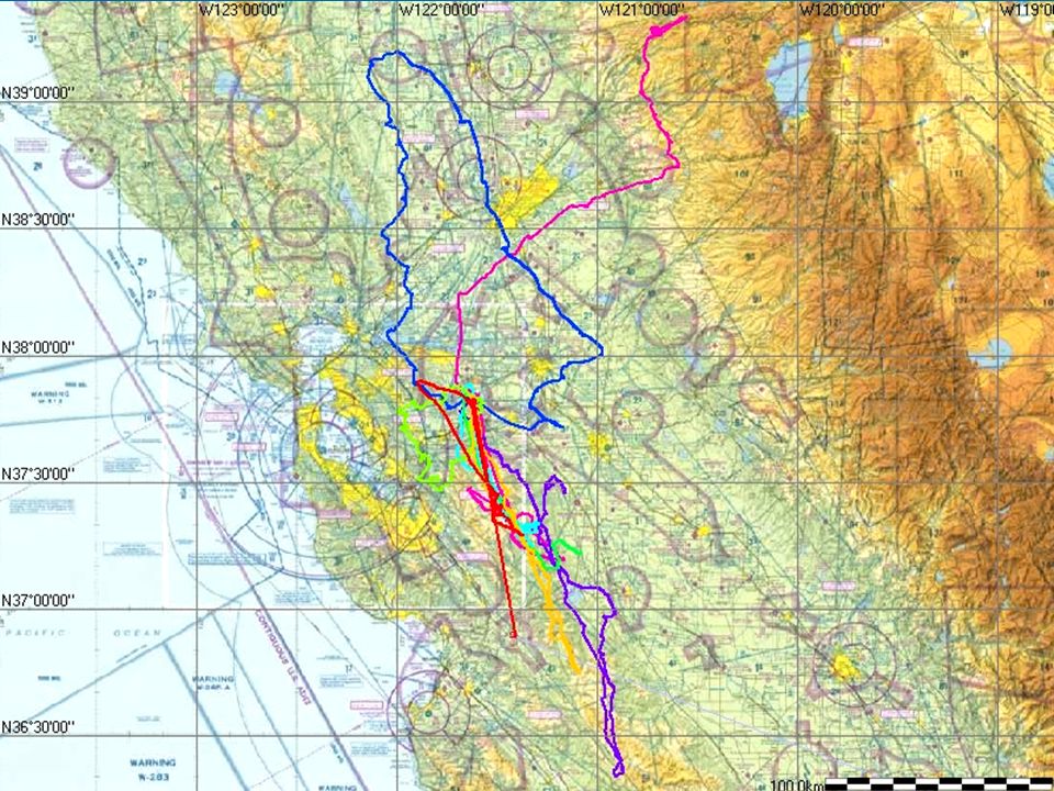
Byron XC Potential 300-500km especially during the spring (March-June) and fall. May require 20-30 miles 6000-7000ft tows when local lift not presents. 25 miles tow @ 80knots = 30 minutes round trip ($67). Typical altitude over the Diablo range south of Byron (not Mt. Diablo) is 6000-8000, occasional 10,000. Soarable most days from Spring to Fall. Easy glide back to Byron.
. Typical altitude over the Diablo range south of Byron (not Mt. Diablo) is , occasional 10,000. Soarable most days from Spring to Fall. Easy glide back to Byron..")
4
2005 Statistics Total distance from Byron – 1736 km in 7 XC flights (averaging 250km per flight) Two 400km flights Typical altitude 6000-9000 ft 40% from local tows 2 Landouts (one in an airport, one in a field)
 Two 400km flights Typical altitude ft 40% from local tows 2 Landouts (one in an airport, one in a field)")
7
Suggested Release Points Rel1 – 20 Statue miles from Byron N37:33:16, W121:36:16 Rel2 – 25 Statue miles from Byron N37:28:43, W121:33:13 Rel3 – 30 Statue miles from Byron N37:24:38, W121:32:33 Rel4 (Mt. Oso) 25 Statue miles from Byron N37:30:14, W121:22:16 Diablo Wave - 37:50.85N,121:54.43W
 25 Statue miles from Byron N37:30:14, W121:22:16 Diablo Wave - 37:50.85N,121:54.43W.")
8
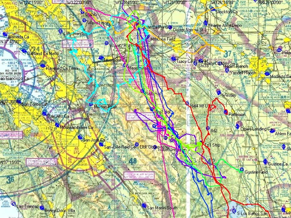
Suggested Routes No need to go to Mt Diablo unless you want to fly local or go north. Poor lift north over the delta except on unstable post frontal days Best route south along the Diablo range Often strong convergence marked with clouds over the highest terrain east of Mt Hamilton towards Mt Oso, persists all day When above 8K you can go in the middle, if lower move towards the west or east side.

9
Suggested Routes (continue) When below 4000ft stick to the foothills on the east side or even move over the hwy, thereis often a weak shear line along the hwy which lasts till late in the day Plenty of places to land on the east side, airstrip every 10 miles or so. Unless clouds indicate otherwise, stay on the east side when crossing the Pacheco pass (sea breeze on the west, potential convergence on the east)
.")
10
Suggested Tasks Byron – Pacheco pass – Byron: 100 miles (Cloud street Milk Run) Byron – San Benito Mtn (EL4) – Byron: 230 miles (300K task gold distance) Byron – Hwy41 (South of Avenal) – Byron: 324 miles (500km diamond distance) Byron – Taft or New Cuyama : 225 miles straight out Byron – New Cuyama – Byron: 450 Miles (700km)
 Byron – San Benito Mtn (EL4) – Byron: 230 miles (300K task gold distance) Byron – Hwy41 (South of Avenal) – Byron: 324 miles (500km diamond distance) Byron – Taft or New Cuyama : 225 miles straight out Byron – New Cuyama – Byron: 450 Miles (700km)")
11
Airport Landout Options (West) Reid Hill view (Tower, OK to land) South County (Morgan Hill, OK to land) Hollister (gliderport)
 Reid Hill view (Tower, OK to land) South County (Morgan Hill, OK to land) Hollister (gliderport)")
12
Airport Landout options (South) Livermore (Tower, OK if can’t make it back to Byron) Meadowlark Tracy New Jerusalem Westley (marginal, probably not aero retrievable) Patterson Crows Landing (Huge, but access unknown) Gustine Los Banos Panoche
 Livermore (Tower, OK if can’t make it back to Byron) Meadowlark Tracy New Jerusalem Westley (marginal, probably not aero retrievable) Patterson Crows Landing (Huge, but access unknown) Gustine Los Banos Panoche")
13
Airports Landouts (North) Rio Vista Nut Tree Multiple strips between Vacaville and Williams
 Rio Vista Nut Tree Multiple strips between Vacaville and Williams")
14
Off Field Options 37:46.79N,121:34.60W - Fields along Mt.House road (watch for power lines) 37:21:38N,121:28:56W,2050F - Good fields by the road on top of the Diablo range. 37:24:06N,121:15:49W,1050F - OK Field in the new development west of Patterson (land to west) 37:13:40N,121:05:17W,200F – Good field along I-5 near Gustine Exit
 37:13:40N,121:05:17W,200F – Good field along I-5 near Gustine Exit.")
15
Tips for safe landouts below the Diablo range Use conservative glide, same as when flying from Truckee. When below 4000 ft move towards the valley Wind direction will usually be from the NW Take an afternoon road trip along I-5 to check the listed airports. Take a scenic trip up the Diablo range (Mines Road from Livermore) and down to Patterson to check the fields.
 and down to Patterson to check the fields..")
16
Suggestions XC Mentoring (practical only for 2 gliders due to length of tows) Get your silver and gold distance from Byron during spring Mad Dash Event– Straight out towards Avenal, Grapevine, Tehachapi or beyond. Pilots and crew needed.

17
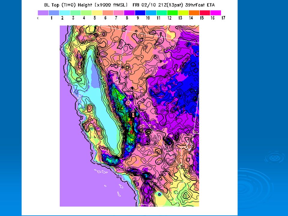
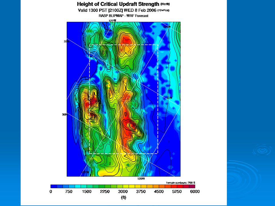
How to use blipmaps for XC planning Check the “CurrentDay” ETA forecast for Saturday on Friday evening Usually available after 6:30PM and updated every few hours Check the BLTop map (Height of Boundary Layer Top) – this is the most important and accurate parameter. It indicates how high you can get in the best thermals. The forecast period is indicated on the top right, 9hrs being the latest right, 9hrs being the latest

18
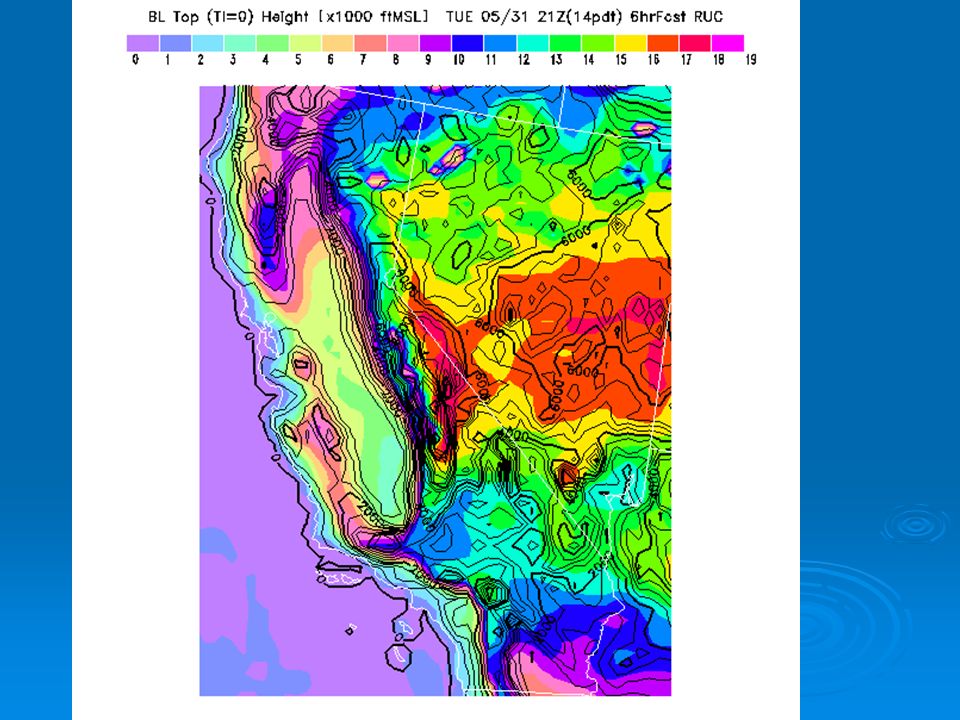
Blipmaps (continue) On Saturday morning, check both the ETA blipmap and the RUC 21Z blipmap. If they disagree, go with the RUC. If both predicting a great day – go fly! Check the Latest RUC BLTop. It is usually accurate within couple of hundred feet (especially the 6 hour forecast, which is usually available after 9:30AM). For higher resolution map check the RASP Hcrit. Check ETA Cumulus potential and Cumulus Cloudbase. Note cloudbase altitude is only valid if cumulus potential is positive. Pay special attention to the area of best lift (usually along the Diablo range south of Byron) to plan the best XC route.
. For higher resolution map check the RASP Hcrit. Check ETA Cumulus potential and Cumulus Cloudbase. Note cloudbase altitude is only valid if cumulus potential is positive. Pay special attention to the area of best lift (usually along the Diablo range south of Byron) to plan the best XC route..")
22
URL’s Hollister waypoint database: http://soaring.gahsys.com/TP/Hollister/ http://soaring.gahsys.com/TP/Hollister/ ETA - http://www.drjack.info/BLIP/ETA/CANV/ http://www.drjack.info/BLIP/ETA/CANV/ RUC - http://www.drjack.info/BLIP/RUC/CANV/ http://www.drjack.info/BLIP/RUC/CANV/ Multitime: http://www.drjack.info/BLIP/RUC/CANV/multitime.html http://www.drjack.info/BLIP/RUC/CANV/multitime.html http://www.drjack.info/BLIP/RUC/CANV/multitime.html Blipspot: http://www.drjack.info/BLIP/RUC/SPOT/index.html http://www.drjack.info/BLIP/RUC/SPOT/index.html UniViewer: http://www.drjack.info/BLIP/univiewer.html http://www.drjack.info/BLIP/univiewer.html RASP: http://www.drjack.info/RASP/PANOCHE/index.html http://www.drjack.info/RASP/PANOCHE/index.html

Similar presentations