Download presentation
Presentation is loading. Please wait.

1
Decision Making for XC and wave soaring from Byron Ramy Yanetz February 2010

2
Byron Soaring Potential Great and consistent soaring conditions are only 20 miles away from March till October Strong convergence often marked with clouds over the San Antonio Valley in the Diablo Range (between Rel 1, Red Mountain and Mt Stake), persists all day with typical altitude of 6000-8000, occasional 10,000 feet (highest 13,500!). Easy glide back to Byron or Tracy. May require 20-25 miles 6000-7000ft tow to Rel 1,2,3 when local lift not presents. 25 miles tow @ 70 knots = 30 minutes tow plane round trip ($82). Equivalent in cost and time to 2 typical tows 10/14 saw 6 high tows to the Diablo range in a period of 3 hours resulting in record distance and altitude (13,000 feet)!
. Equivalent in cost and time to 2 typical tows 10/14 saw 6 high tows to the Diablo range in a period of 3 hours resulting in record distance and altitude (13,000 feet)!.")
3
Where to Release? Make sure to use the Hollister database to find the release area Tow towards release 1 (Rel 1) at 70-75 knots so you will arrive there between 6-7000 feet in about 15 min. Release (or stay on tow) and proceeed towards Rel 2 along the spine until you find your first lift. No need to stay on tow beyond Rel 2 or above 7000 feet which is sufficient altitude to search for lift without loosing glide to Byron First lift is usually near Rel 2 If not proceed to Rel 3 and/or to Red Mountain on the edge of the San Antonio valley The lift is almost always in the area between Rel2,3, and Red Mountain. Follow the convergence line between red mountain and Mt Stake If no lift found head back to Byron before loosing glide (or Tracy if Byron is not in glide). Easy in a 40:1 ship but also doable in a Grob
 at knots so you will arrive there between feet in about 15 min. Release (or stay on tow) and proceeed towards Rel 2 along the spine until you find your first lift. No need to stay on tow beyond Rel 2 or above 7000 feet which is sufficient altitude to search for lift without loosing glide to Byron First lift is usually near Rel 2 If not proceed to Rel 3 and/or to Red Mountain on the edge of the San Antonio valley The lift is almost always in the area between Rel2,3, and Red Mountain. Follow the convergence line between red mountain and Mt Stake If no lift found head back to Byron before loosing glide (or Tracy if Byron is not in glide). Easy in a 40:1 ship but also doable in a Grob.")
4
Release Area

5
Landout options Meadowlark (good strip, friendly owner, easy ground retrieve) San Antonio Valley (in the Diablo Range) - Landing strip and good fields – 1 hour drive from Byron (locked gate but key is available) Tracy – Quick aeroretrieve (< $50) New Jerusalem Patterson Crows Landing (Huge, but access unknown) Gustine Los Banos
 San Antonio Valley (in the Diablo Range) - Landing strip and good fields – 1 hour drive from Byron (locked gate but key is available) Tracy – Quick aeroretrieve (< $50) New Jerusalem Patterson Crows Landing (Huge, but access unknown) Gustine Los Banos")
6
How to use blipmaps to determine when to tow to the Diablo Range NAM BLTop > 6000 ft NAM Cu potential >= 0 and Cu Base > 6000 ft RASP Hcrit > 6000 ft However If NAM predicts good cu’s (cu potential > 0) and cloud base of at least 4000ft all the way north across the delta then plan to fly north towards Rio Vista and Williams Detrermine best time to launch. Typically no later than noon, and as early as 10AM if the 10AM RASP indicates good lift.

10
Byron Wave Byron wave season Nov-April Pre frontal wave is best during the hours before the onset of rain with increasing SW winds. Pre Frontal Wave can be found anywhere between Byron and Los Vaqueros reservoir Often marked with Lenticular clouds or foehn gaps Pre frontal wave can be over wide area between Mt Diablo to Mt Oso along the mountain range

11
Diablo North wind Wave Usually during high pressure off shore events from Nov – April Requires NNW-NNE winds above 20 knots at Mt Diablo Usually not marked by clouds other than some high clouds Wave is typically weak (1-2 knots) and very small area (less than 1 square mile) between Wave1 and Class Bravo Due to significant sink surrounding the wave it is crucial to tow all the way to the wave. Avoid the temptation to release early! Stay in the area and move over class bravo if necessary when above 10K. Typical altitude 12-18K

12
Wave 1

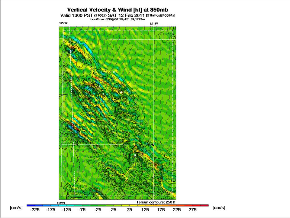
13
How to use blipmap to recognize good wave day Ignore all the thermal related parameters (BLTop, Hcrit, Cu Pot, BL Up/Down, Convergence) Focus on winds aloft (Wind Speed and direction at boundary layer) and wave parameters. NAM is available up to 3 days in advance but only indicates wind. Look for wind above 15 knots from the North or SW. RASP wave parameters, especially the 750m model (available late in the prior evening) are the best indicators. Check the vertical velocity at 850, 700 and 500 mb as well as the Mt Diablo Cross section. Should be over 100 cm/s (2 knots) for a usable wave. On the day itself check the wind on top of Mt Diablo online or by phone. Look for average wind speed above 20 knots from the SW or from the north.
 are the best indicators. Check the vertical velocity at 850, 700 and 500 mb as well as the Mt Diablo Cross section. Should be over 100 cm/s (2 knots) for a usable wave. On the day itself check the wind on top of Mt Diablo online or by phone. Look for average wind speed above 20 knots from the SW or from the north..")
16
Resources Go to NCSA web site http://norcalsoaring.org/ and study the cross country and weather sections, as well as the RASP links http://norcalsoaring.org/ Download latest waypoints for Byron/Hollister area http://soaringweb.org/TP/Hollister http://soaringweb.org/TP/Hollister Mt Diablo wind (925)838-9225 http://raws.wrh.noaa.gov/cgi- bin/roman/meso_base.cgi?stn=MDAC1&unit=0&time=LOCAL http://raws.wrh.noaa.gov/cgi- bin/roman/meso_base.cgi?stn=MDAC1&unit=0&time=LOCAL http://raws.wrh.noaa.gov/cgi- bin/roman/meso_base.cgi?stn=MDAC1&unit=0&time=LOCAL Study routes using google map http://maps.google.com/maps?q=http://soaringweb.org/TP/Hollister/ hllstr0b.kmz&z=7 http://maps.google.com/maps?q=http://soaringweb.org/TP/Hollister/ hllstr0b.kmz&z=7 http://maps.google.com/maps?q=http://soaringweb.org/TP/Hollister/ hllstr0b.kmz&z=7 Study landouts data http://www.soaringnet.com/landout_data/hollister http://www.soaringnet.com/landout_data/hollister Download IGC files from OLC and study with SeeYou
 bin/roman/meso_base.cgi stn=MDAC1&unit=0&time=LOCAL bin/roman/meso_base.cgi stn=MDAC1&unit=0&time=LOCAL bin/roman/meso_base.cgi stn=MDAC1&unit=0&time=LOCAL Study routes using google map q= hllstr0b.kmz&z=7 q= hllstr0b.kmz&z=7 q= hllstr0b.kmz&z=7 Study landouts data Download IGC files from OLC and study with SeeYou")
Similar presentations