Download presentation
Presentation is loading. Please wait.

1
Deformation Mr Boland Geography

2
The earths crust is divided into layers
The earths crust is divided into layers. But because the earths plates are convergent, neutral and divergent the layers of the earths crust have been changed and deformed. The three types of deformation are 1. Folding 2. Faulting 3. Doming

3
Folding of rocks occurs when they are compressed or squeezed
Folding of rocks occurs when they are compressed or squeezed. Rock can be folded because at depth it is subjected to great heat and pressure which makes the rock flexible and so it cab bend without breaking The parts of folds are 1. Anticlines- this is the upfold or the ridge. 2. Synclines- this is the downfold or the valley. 3. Limbs- these are the arms of the folds. 1. Folding

5
Types of folding There are many different types of folds such as.
Monocline-horizontal layers tilt in one direction Symmetrical (simple) folds- where both slopes of the anticline are equal. Asymmetrical fold- where one slope of the anticline is greater than the other. Overfold-Where one slope of the anticline has overturned. Overthrust fold- the rock strata are no longer continous because the folding is so great it has called a fault/ crack and one limb is pushed over the other. Types of folding
 folds- where both slopes of the anticline are equal. Asymmetrical fold- where one slope of the anticline is greater than the other. Overfold-Where one slope of the anticline has overturned. Overthrust fold- the rock strata are no longer continous because the folding is so great it has called a fault/ crack and one limb is pushed over the other. Types of folding.")
7
Fold Mountains There are three types of fold mountains.
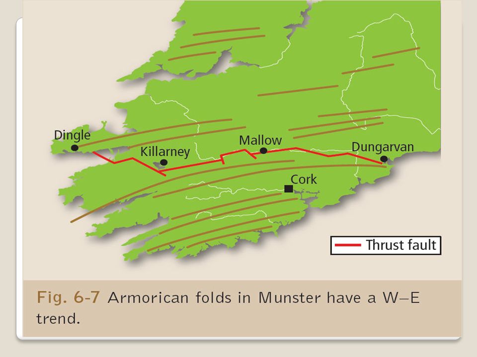
Caledonian fold mountains. Armorican fold mountains. Alpine fold mountains. Irelands mountains are Caledonian and Armorican fold mountains. Fold Mountains

8
Caledonian Fold Mountains
When the American and Eurasian plate collided it resulted in intense folding and compressing of sand and mud from the sea bed. Igneous rock then formed as magma forced its way under the folds and cooled. This also resulted in metamorphic rock being formed as the heat from the magma changed any rock in came in contact with. Caledonian Fold Mountains

10
Caledonian Fold Mountains
Examples of Caledonian fold mountains are Wicklow- Dublin mountains, Donegal mountains and the Galway/ Mayo mountains. These mountains all run from the northeast to southwest. Caledonian Fold Mountains

15
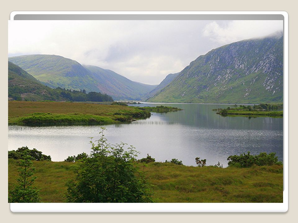
The Armorican fold mountains formed less than 300 million years ago and affects the south of Ireland. These mountains run east to west and give rise to a distinct “ridge and valley” landscape. Anticlines (ridges) of red sandstone are separated by synclines (valleys) of limestone and shale. It is this folding that lifted the karst landscape of the Burren from beneath the sea Armorican Folding
 of red sandstone are separated by synclines (valleys) of limestone and shale. It is this folding that lifted the karst landscape of the Burren from beneath the sea. Armorican Folding.")
20
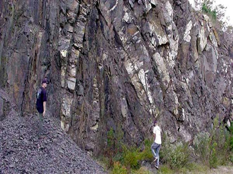
Reverse Fault There is an example of a Reverse fault running from Dungarvan to Dingle Bay, where the African and Eurasian plate collided. The pressure pushed the sandstone on top of the limestone.

21
When the African and Eurasian plate converged 30 million years ago it formed alpine fold mountains like the Alps. These are young fold mountains. Earthquake activity in the area show that the plates are still converging Alpine Mountains

24
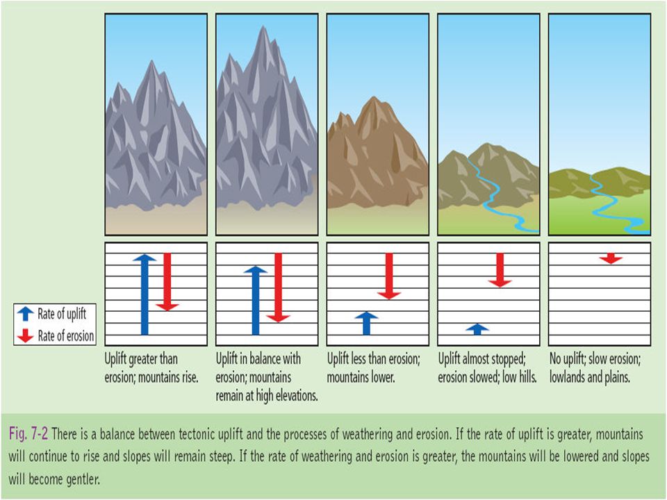
When plates are pushing together it causes uplift this means that the mountains are getting higher, if the rate of erosion is greater than the uplift the mountains gets eroded and get smaller. If the rate of uplift is greater than erosion the mountain continues to grow.

26
Global distribution of fold mountains

27
Fold mountains are found at only one plate margin- Convergent margins.
At convergent margins fold mountains only occur at Oceanic- continental margin Contenental- continental margins

28
Continental- Oceanic Margin
Ex;Nazca plate & South American Plate forming the Andes. The heavier oceanic crust slides beneath the lighter contennetal crust. As the plates collide, the sea- floor sediments carried by plate collision slowly compresses the sediments and uplifts them. At the same time the rocks of the continental crust are also folded and uplifted. Fold mountains formed in this way may also have volcanic mountains within them. This is because as the oceanic crust is subducted below the continental crust, it melts and is recycled; Ex-Cotapaxi . Continental- Oceanic Margin

29
Continental- Continental Margin
When two continental plates collide such as the India and Eurasian plate neither plate sinks into the mantle. This is due to plates being rich in silicon and aluminium (sial) that are less dense than the material below so they float of the surface of the mantle. Rocks on both sides are folded and uplifted. Example Himalayas Continental- Continental Margin
 that are less dense than the material below so they float of the surface of the mantle. Rocks on both sides are folded and uplifted. Example Himalayas. Continental- Continental Margin.")
30
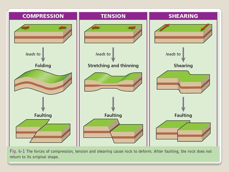
2.Faulting

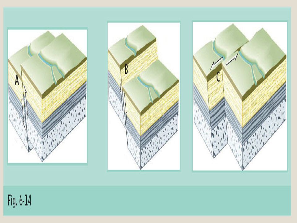
31
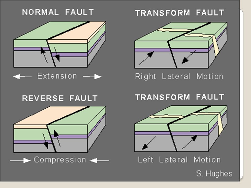
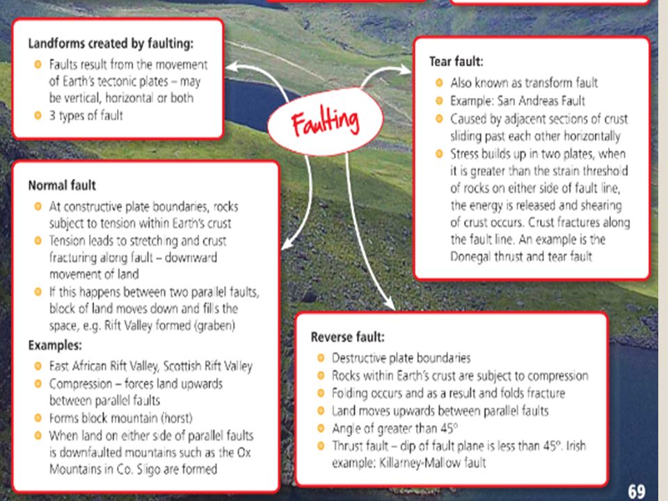
Faulting happens when pressure is so intense it open a fracture in the ground. This could result in the fracture running along a fault line. Movement here can be up/down/side to side. Types of faults are, normal, reverse & tear faults.

35
1. Normal fault When two plates are separating a fracture occurs, one plate slips downwards due to gravity. Normal faults result in rift valleys and block mountains.

36
The east African rift valley is widening due to continental divide.
Rift Valleys When two normal faults are parallel to each other, the inner slab slips down as the crust parts. This is what causes rift valleys or graben as they are sometimes know. The east African rift valley is widening due to continental divide.

38
Block mountains Block mountains form due to compression between diverging plates. The Ox mountains are an example of a block mountain. A block mountain is also know as a Horst.

39
2.Reverse Fault When plates converge a fracture may open in the earth. angel greater than 45 degress This causes one plate to be forced up as the pressure increases, when the crust is shortened it is know as a reverse fault.

41
Reverse Fault There is an example of a Reverse fault running from Dungarvan to Dingle Bay, where the African and Eurasian plate collided. The pressure pushed the sandstone on top of the limestone.

42
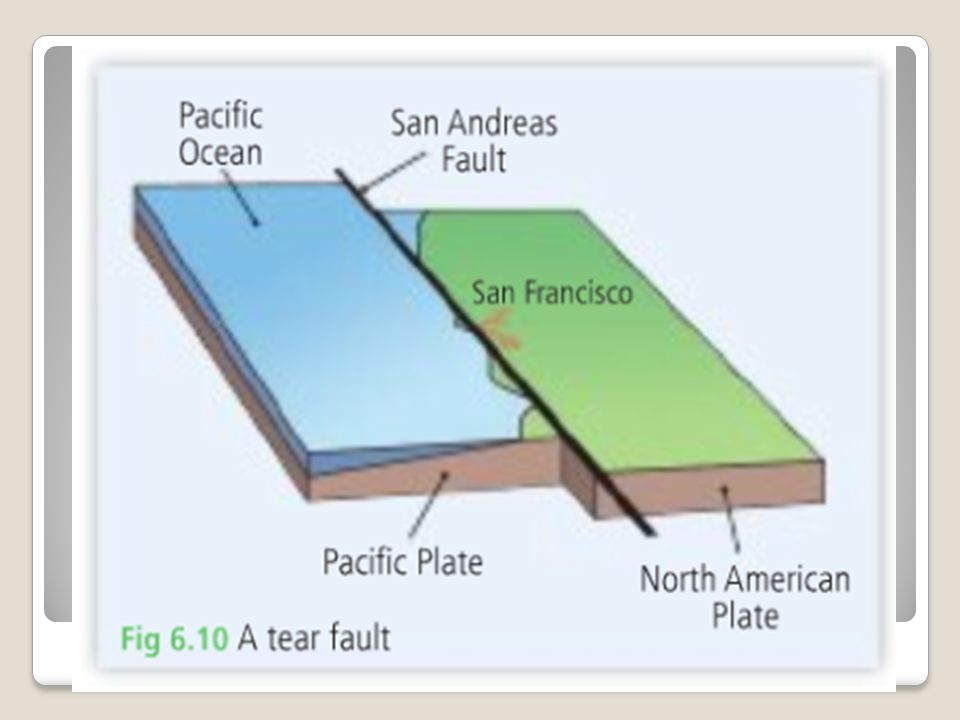
Tear Faults This is a fault where one block moves sideways or horizontally past another instead of up and down. EX; San Andreas Fault Line

44
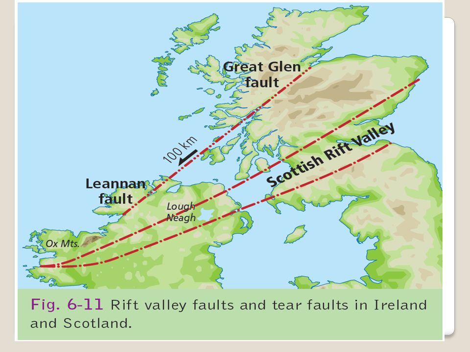
In Ireland the Lennon tear fault in Donegal is an extension of the Great Glen fault in Scotland. Here the North of the fault moved in a SW direction for 100 km.

47
The rocks along this fault badly crushed so they are weathered and eroded very easily.
This means rivers can cut easily into the fault.

48
Folding???? Faulting

49
Armorican Fold Mountains

51
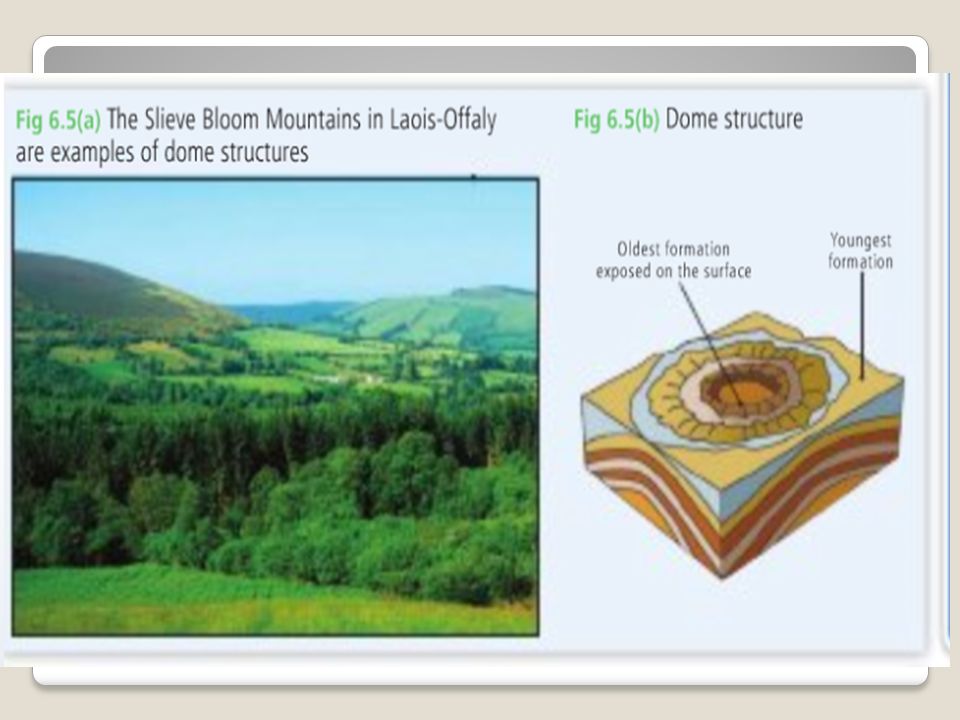
Doming

52
A sedimentary dome looks like an upturned bowl.
The original structure was a bed of flat lying sedimentary rock. Great amounts of magma pushed up from under the asthenosphere forcing the layers up without breaking or faulting them.

53
Often the magma underneath cool to form igneous rock.
Over time the sedimentary rock is weathered and eroded to leave a granite dome. ExampleSlieve Bloom in Laois were formed 60 million years ago as 3. Doming

54
Granite dome surrounded by sedimentary rock

58
Questions

64
Examine the impact of folding and faulting on the Irish landscape.
Describe how the study of plate tectonics help us understand the location of fold mountains. 30 Mark Questions

Similar presentations


 Divergent Boundary (Ridge) 2)>")
: SWBAT describe the layers of the Earth. SWBAT describe the plate tectonics theory including, how plate tectonics operating.>")


