Download presentation
Presentation is loading. Please wait.

1
Regional GIS User Group Meeting Wednesday, May 13 th 2009 10:00 AM - Noon Amphitheater, C – Level NEXT MEETING SEPTEMBER 9th www.atlantaregional.com/rgug www.atlantaregional.com/gis

2
Cooperative Purchase Agreement Must decide if you are going to join Sanborn quote and specs in handout –Review for changes and make decision Present to ARC Board as a programmatic element for Calendar year 2010 USGS contributing

3
Interested Counties

4
Next Steps Sign the Letter of Intent Speak with your local executives and talk to the other counties Ask questions now and as soon as you have reviewed everything

5
RC Tool Tool available at atlantaregional.com/gis

6
GIS Training at ARC Trained 75 people since March of 2008 Now teaching the authorized ESRI ArcGIS Desktop 9.3 curriculum New course structure, lectures and exercises from previous version Currently offering ArcGIS Desktop I and II, plan to add Desktop III next year Registration is handled through ARC’s Community Planning Academy Next class will be ArcGIS Desktop I: Getting Started with ArcGIS on May 14-15 Then ArcGIS Desktop II: Tools and Functionality on July 15-17 Cost is $225 for Desktop I (2 days) and $340 for Desktop II (3 days) Available to local government staff only (city, county, water authorities, transit agencies, etc.) Class size limited to 12 Email class announcements go out in advance of classes Check the Community Planning Academy page of ARC’s website for upcoming classes and online registration, ESRI website for course details Please contact Paul DiGirolamo at 404-463-3520 or pdigirolamo@atlantaregional.com for more information pdigirolamo@atlantaregional.com
 and $340 for Desktop II (3 days) Available to local government staff only (city, county, water authorities, transit agencies, etc.) Class size limited to 12 class announcements go out in advance of classes Check the Community Planning Academy page of ARC’s website for upcoming classes and online registration, ESRI website for course details Please contact Paul DiGirolamo at or for more information")
7
ArcGIS Server Migrating from ArcIMS 9.2 to ArcGIS Server platform –Completed implementation of Latitude Geographics Geocortex Essentials for ArcGIS Server 9.2 –Upgraded ArcIMS 9.2 to 9.3 –Upgraded ArcGIS Server 9.2 to 9.3 and Geocortex Essentials 1.5.1 –Configuration and Internal Testing of GE application –Geocortex Essentials Training in Charlotte –ArcIMS services stopped –ArcGIS Server/Geocortex Essentials website is available!

8
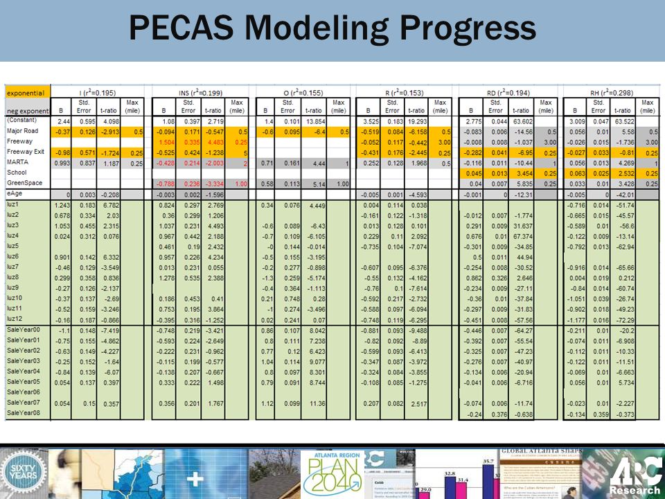
PECAS −Production Exchange Consumption Allocation System −Developed by Drs Doug Hunt and John Abraham of University of Calgary −I-O economic model approach −Two Modules, run Sequentially and Annually Activity Allocation (HH and Jobs) Module Space Development Module −78 LUZ zones for 20-County model −Landuse forecast −Small area population and employment forecast −Generate input for Travel Demand Model PECAS Modeling Progress
 Module Space Development Module −78 LUZ zones for 20-County model −Landuse forecast −Small area population and employment forecast −Generate input for Travel Demand Model PECAS Modeling Progress")
9
SD Progress –Build rent equations for Fulton –Build Space Synthesizer for 15 counties –Evaluation and Calibration of Initial Results from Synthesizer Runs –Migrate SD to PostgreSQL PECAS Modeling Progress

11
AA Progress –Initial Integration with Travel Demand Model (Skims) –Unconstrained Run in June of 2008 –Beginning of 2 nd Stage Calibration (Imports and Exports; Option Sizes) –Development of Constraint Values (Jobs, Households by Income, Imports/ Exports) –Constrained AA Run October 2008 PECAS Modeling Progress
 –Unconstrained Run in June of 2008 –Beginning of 2 nd Stage Calibration (Imports and Exports; Option Sizes) –Development of Constraint Values (Jobs, Households by Income, Imports/ Exports) –Constrained AA Run October 2008 PECAS Modeling Progress")
12
Data Development Progress –PUMS,IMPLAN, SF3 Data Development for Use with AA –Employment by PECAS category (industry by occupation by space type) –Development of Space Constraints Using NAICS Employment and LandPro PECAS Modeling Progress
 –Development of Space Constraints Using NAICS Employment and LandPro PECAS Modeling Progress")
13
In 2009 –Build Synthesizer for remaining 5 counties –Standardize zoning and density layer –Recode ARC SD model –Code rent equations into SD –Floorspace quantity adjustment –Establish Transport Cost Coefficients –Revise Design Diagram –Start calibrating prices from AA PECAS Modeling Progress

14
TAZ Disaggregator What is TAZ-D? - ArcMap Extension - Spatial Analyst - Developed By PBS&J

15
TAZ Disaggregator What will TAZ-D do? –TAZ level data for Travel Demand Model –Disaggregate future forecast to Super Districts (78) and TAZs (2024) -landuse -employment -household -population –Improve ARC Zapping procedure replace FORTRAN programs Incorporate geospatial factors vs. existing share based
 and TAZs (2024) -landuse -employment -household -population –Improve ARC Zapping procedure replace FORTRAN programs Incorporate geospatial factors vs. existing share based.")
16
TAZ Disaggregator Major Input data: –REMI forecast –Landpro –Street centerline –Travel impedance matrix –Transit –Parcels –Any geospatial factors

17
TAZ Disaggregator How does TAZ-D disaggregate…? –Apply factors and weighted scores –Spatial Analyst & raster conversion –Calculate and rank the likelihood of development –Calibration –Allocate the future development –Make animation

18
TAZ Disaggregator Output –At Super District and TAZ level: Future employment by 21 NAICS categories Population Household by 4x6 HHInc Size categories –Animation of future development Progress –Working on redevelopment module –Will test the full function and calibration in next two weeks

19
TAZ Disaggregator

20
Other Announcements

Similar presentations


>")

 Modelling Group London, UK 2 July 2005 Calgary Testbed for.>")


