Download presentation
Presentation is loading. Please wait.

1
How do you locate your coordinates? How do you document the location? How do you map of the area so that the information is useful to you and others? Set useful tools are DNR Garmin Application, a handheld GPS Device, and ArcGis Explorer. Presented By: Jay Thompson Bryan Wallace Jon Kipling

2
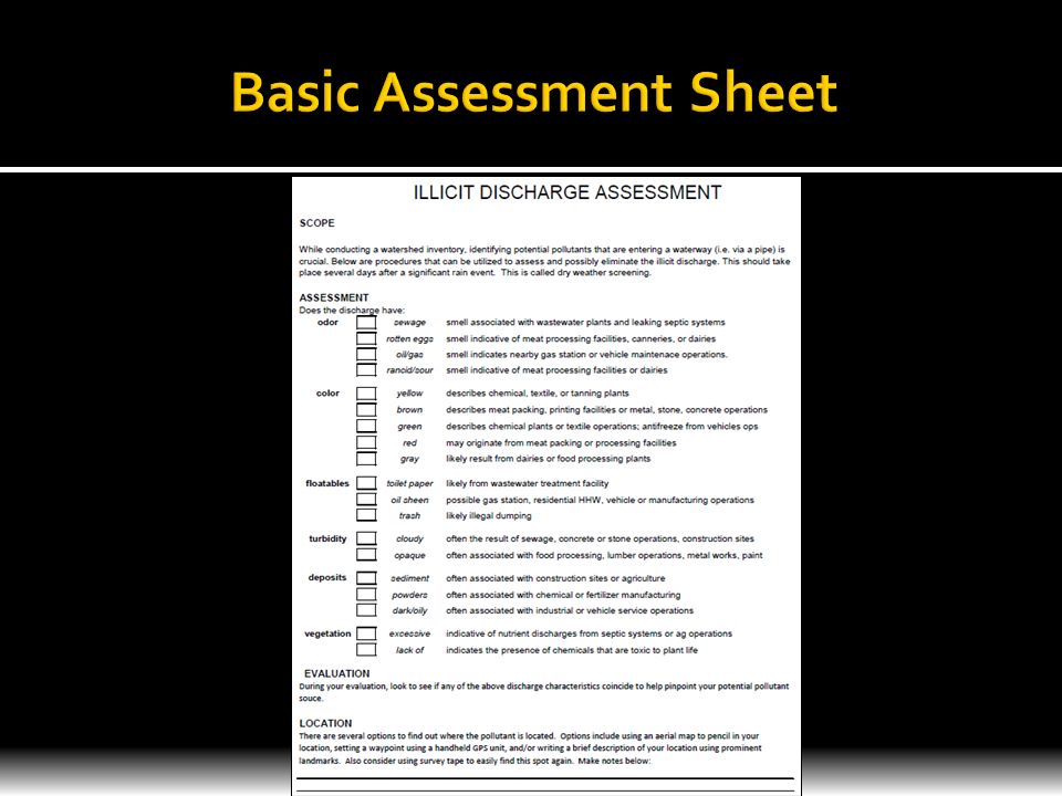
Project: We generated a Standard Operating Procedure, assessment form, and detailed notes on GPS data integration. This will provide resources and methods of tracking down illicit discharges so they can be eliminated. Purpose: To provide new Watershed Coordinators with tools to work towards improving the water quality in their area. How do you locate your coordinates? How do you document the location? How do you map of the area so that the information is useful to you and others? Set useful tools are DNR Garmin Application, a handheld GPS Device, and ArcGis Explorer.

3
How do you locate your coordinates? How do you document the location? How do you map of the area so that the information is useful to you and others? Set useful tools are DNR Garmin Application, a handheld GPS Device, and ArcGis Explorer. Known as Illicit Discharge Detection and Elimination. Means to find a pollutant entering a storm sewer or drainage system, which drains to the local waterway. These discharges should be eliminated if possible.

4
How do you locate your coordinates? How do you document the location? How do you map of the area so that the information is useful to you and others? Set useful tools are DNR Garmin Application, a handheld GPS Device, and ArcGis Explorer.

6
How do you locate your coordinates? How do you document the location? How do you map the area so that the information is useful to you and others? Set of useful tools are DNR Garmin Application, a handheld GPS Device, and ArcGis Explorer or Google Earth How do you locate your coordinates? How do you document the location? How do you map of the area so that the information is useful to you and others? Set useful tools are DNR Garmin Application, a handheld GPS Device, and ArcGis Explorer.

7
A. Waypoints are locations or landmarks worth recording and storing in your GPS. These are locations you may later want to return to. They may be check points on a route or significant ground features. (e.g., camp, the truck, a fork in a trail, or a favorite fishing spot). Waypoints may be defined and stored in the unit manually, by taking coordinates for the waypoint from a map or other reference. This can be done before ever leaving home. Or more usually, waypoints may be entered directly by taking a reading with the unit at the location itself, giving it a name, and then saving the point. Waypoints may also be put into the unit by referencing another waypoint already stored, giving the reference waypoint, and entering the distance and compass bearing to the new waypoint. Copyright 1996- 2010 Garmin Ltd. or its subsidiaries
. Waypoints may be defined and stored in the unit manually, by taking coordinates for the waypoint from a map or other reference. This can be done before ever leaving home. Or more usually, waypoints may be entered directly by taking a reading with the unit at the location itself, giving it a name, and then saving the point. Waypoints may also be put into the unit by referencing another waypoint already stored, giving the reference waypoint, and entering the distance and compass bearing to the new waypoint. Copyright Garmin Ltd. or its subsidiaries.")
8
DESKTOP ANALYSIS Google Earth - http://earth.google.com/ ArcGis Explorer - http://www.esri.com/software/arcgis/explorer/index.html IN THE FIELD Handheld GPS Device (500 to 1000 points)
")
9
http://www.dnr.state.mn.us/mis/gis/tools/arcview/extensions/DNRGarmin/DNRGarmin.html

10
500 to 1000 Waypoints to be formatted DNR Garmin Choices Shapefiles (*.shp) DataBase IV (*.dbf) Text File (*.txt) Google Earth Format (*.kml) GPS Exchange (*.gpx)
 DataBase IV (*.dbf) Text File (*.txt) Google Earth Format (*.kml) GPS Exchange (*.gpx)")
11
Web Search: google_earth_user_guide.pdf

12
Format Waypoints to GPS Exchange (*.gpx) and Save File Drag and Drop Saved File into My Places Window Format Style
 and Save File Drag and Drop Saved File into My Places Window Format Style")
13
Using GPS Devices with Google Earth Format Waypoints to Text File (*.txt) and Save File Open “Add Content” “Text Files” Load Saved *.txt File Format Style
 and Save File Open Add Content Text Files Load Saved *.txt File Format Style")
14
Using GPS Devices with Google Earth

15
Format Style

16
Step 1 - http://www.zonums.com/gmaps/digipoint.php

17
Step 2

18
Step 3

19
Step 4 Step 5 Step 6

20
Step 7 Step 8

21
Step 9 Step 10 Save File in GPS Exchange (*.gpx) for Google Earth Save File in Text File (*.txt) for ArcGis Explorer See Steps above “ Using GPS Devices”
 for Google Earth Save File in Text File (*.txt) for ArcGis Explorer See Steps above Using GPS Devices")
22
Thank You

Similar presentations


 EasyGPS Free software for downloading.>")


 is a system of satellites maintained by the US Department of Defense for.>")


 With a heavy debt to Richard Thompson (Glonch’sPride) of New Hampshire, whose presentation I borrowed and adapted.>")


